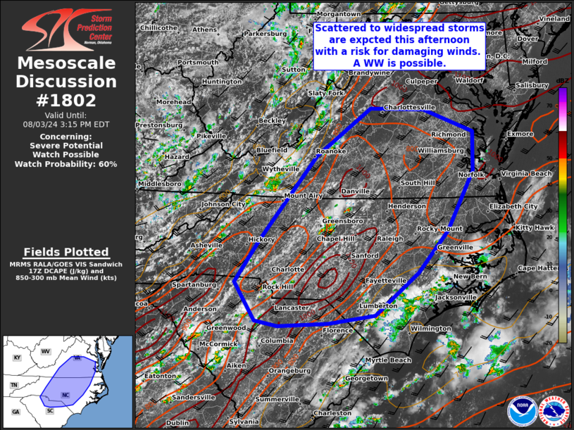
MD 1802 CONCERNING SEVERE POTENTIAL…WATCH POSSIBLE FOR SOUTHERN VIRGINIA…MUCH OF NORTH CAROLINA AND INTO FAR NORTHERN SOUTH CAROLINA.
Mesoscale Discussion 1802
NWS Storm Prediction Center Norman OK
1239 PM CDT Sat Aug 03 2024

Areas affected...southern Virginia...much of North Carolina and into
far northern South Carolina.

Concerning...Severe potential...Watch possible

Valid 031739Z - 031915Z

Probability of Watch Issuance...60 percent

SUMMARY...Scattered thunderstorm development should commence early
this afternoon off the higher terrain. A few stronger clusters may
emerge with a risk for damaging gusts. A WW is being considered.

DISCUSSION...As of 1730 UTC, regional satellite imagery showed
deepening cumulus towers and initial thunderstorm development was
ongoing over parts of the Carolinas and southwestern VA. Aided by
ascent from a broad eastern US trough, strong diurnal heating atop a
very humid air mass (dewpoints in the mid to upper 70s F) will
remove lingering inhibition over the next couple of hours. Scattered
to widespread thunderstorms are likely by mid afternoon. Despite
only modest mid-level lapse rates, the robust heating will support
moderate to strong buoyancy with 2000-3000 J/kg of MLCAPE favorable
for strong updrafts. Somewhat enhanced mid-level flow ahead of the
trough may also support storm organization into multi-cell clusters,
with effective shear values around 25 kt.

AS storms gradually increase in coverage and intensity, a few more
organized clusters may evolve as individual cold pools begin to
consolidate. With the marginal shear values for storm organization,
a few of these clusters may have greater longevity and more intense
cores. With very high PWATS near 2 inches and the large buoyancy,
damaging downdraft winds are the most likely threat. Confidence in
storm coverage appears greatest over parts of southern VA into
central NC. With the risk for damaging winds likely to increase over
the next couple of hours, a WW is being considered.

..Lyons/Hart.. 08/03/2024

...Please see www.spc.noaa.gov for graphic product...

ATTN...WFO...AKQ...MHX...LWX...RAH...ILM...RNK...CAE...GSP...

LAT...LON   35808108 37267987 38097872 38077760 37677653 36997655
            35977709 35257773 34527863 34387962 34338067 34428116
            35098158 35808108


