2024-06-29 17:00:04
1719695364
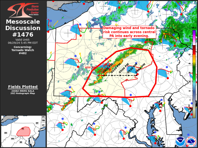
MD 1476 CONCERNING TORNADO WATCH 482… FOR CENTRAL/EASTERN PA
Mesoscale Discussion 1476
NWS Storm Prediction Center Norman OK
0309 PM CDT Sat Jun 29 2024

Areas affected...central/eastern PA

Concerning...Tornado Watch 482...

Valid 292009Z - 292145Z

The severe weather threat for Tornado Watch 482 continues.

SUMMARY...A risk for damaging gusts and a couple tornadoes will
continue into early evening across central into eastern PA.

DISCUSSION...A line of convection over central PA will continue to
track toward the east at around 35-45 mph over the next few hours.
This activity has a history or producing sporadic wind damaging
across western and central PA this afternoon. The downstream airmass
has warmed into the upper 80s amid near-70 F dewpoints. Lapse rates
will remain poor, limiting stronger instability, though around 1000
J/kg MLCAPE is expected to spread eastward with time. Effective
shear magnitudes around 40 kt, and enlarged, favorably curved
low-level hodographs will continue supporting organized convection
with a risk of damaging gusts and a couple of tornadoes. If current
trends are maintained, an aerial watch extension may be needed
across southeastern portions of WFO CTP as convection is expected to
near the edge of Tornado Watch 482 by around 22z. The need for a
downstream watch into portions of far southeast PA and NJ remains
uncertain, but trends will be monitored.

..Leitman.. 06/29/2024

...Please see www.spc.noaa.gov for graphic product...

ATTN...WFO...PHI...CTP...LWX...PBZ...

LAT...LON   41357721 41277641 40707607 40177612 39747645 39707732
            39757894 39987928 40597887 41227783 41357721