
In brief: The massive winter storm that will bear down on much of the Northeast and Mid-Atlantic is about to kick off, so this post just runs through the expectations at the final hour.
Hopefully you all were able to watch Team USA take the gold this morning, and if you love cold and winter, the day should only get better for you in the Northeast and parts of the Mid-Atlantic. Here, we’ll walk you through the various expectations now that we’re in the final moments before the storm really begins.
Snow totals
This should not be a major storm in the DC Metro, though a few inches are possible.
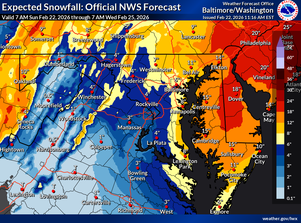
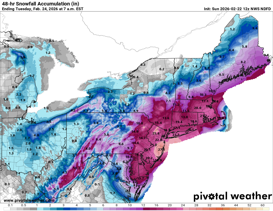
Snow totals begin to ramp as you approach the northwest and east side of the Chesapeake Bay. Around a half-foot is expected in Baltimore with higher totals to the east, rapidly escalating to 12 to 18 inches from Salisbury, MD north across all of Delaware. A period of mixing near the coast may hold totals down there a bit, particularly around Ocean City, MD.
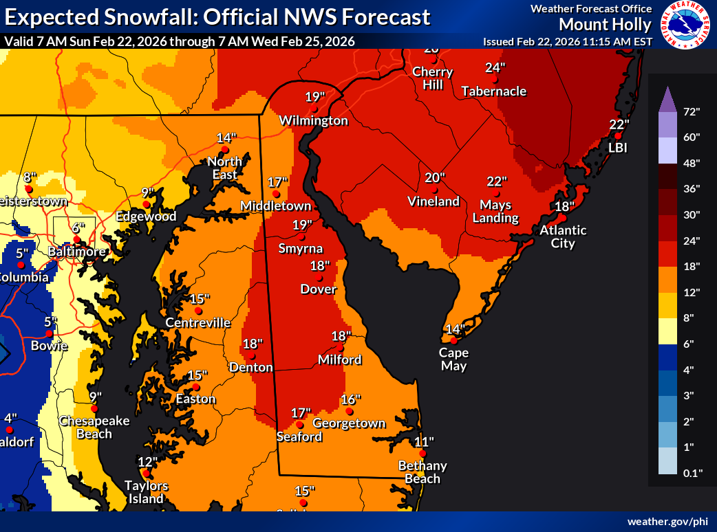
Snow totals really crank once into New Jersey with 12 to 24 inches likely in all of South Jersey. The riskiest spots for lower totals may be in Cape May County up to about Atlantic City and for the Delaware Beaches where a period of sleet or rain may mix in with the snow for a time, cutting totals down a little. There will still be a *lot* of snow.
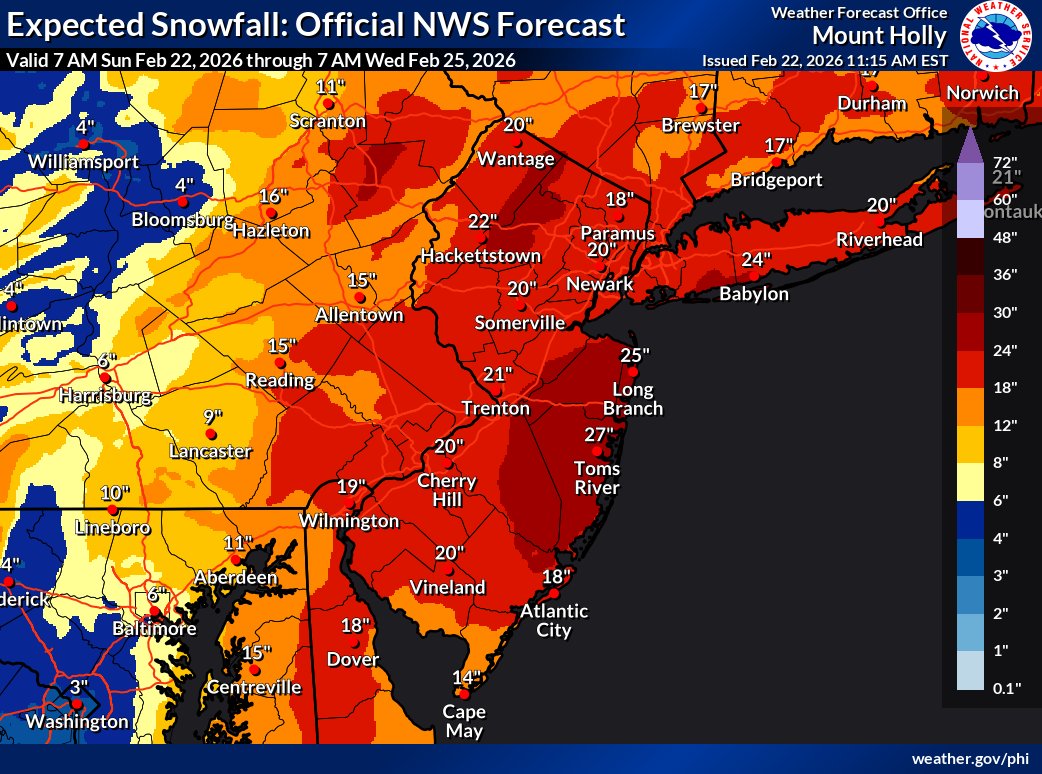
The gold medal winners for this snowstorm will probably be somewhere in Ocean or Monmouth Counties in New Jersey or just southwest of there, where we could, theoretically, see someone pick up nearly 25 inches of snow. We’ve seen some models put out 30-inch totals here, but I do think snow ratios may hinder that effort a bit. Likely someone between Salem County and Monmouth County will pick up 25 inches or more when all is said and done and be crowned champion. Elsewhere, 12 to 20 inches of snow is likely across most of the rest of New Jersey.
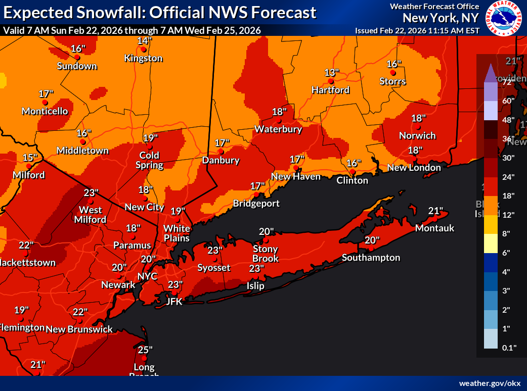
Around 20 inches of snow is expected for most of the New York City Metro with closer to 12 to 18 inches up into Connecticut and perhaps higher totals on Long Island. To make the top 10 list all-time for snowstorms in New York City, we’ll need to see at least 18.2 inches at Central Park. We need 14.1 inches for the top 20 list.
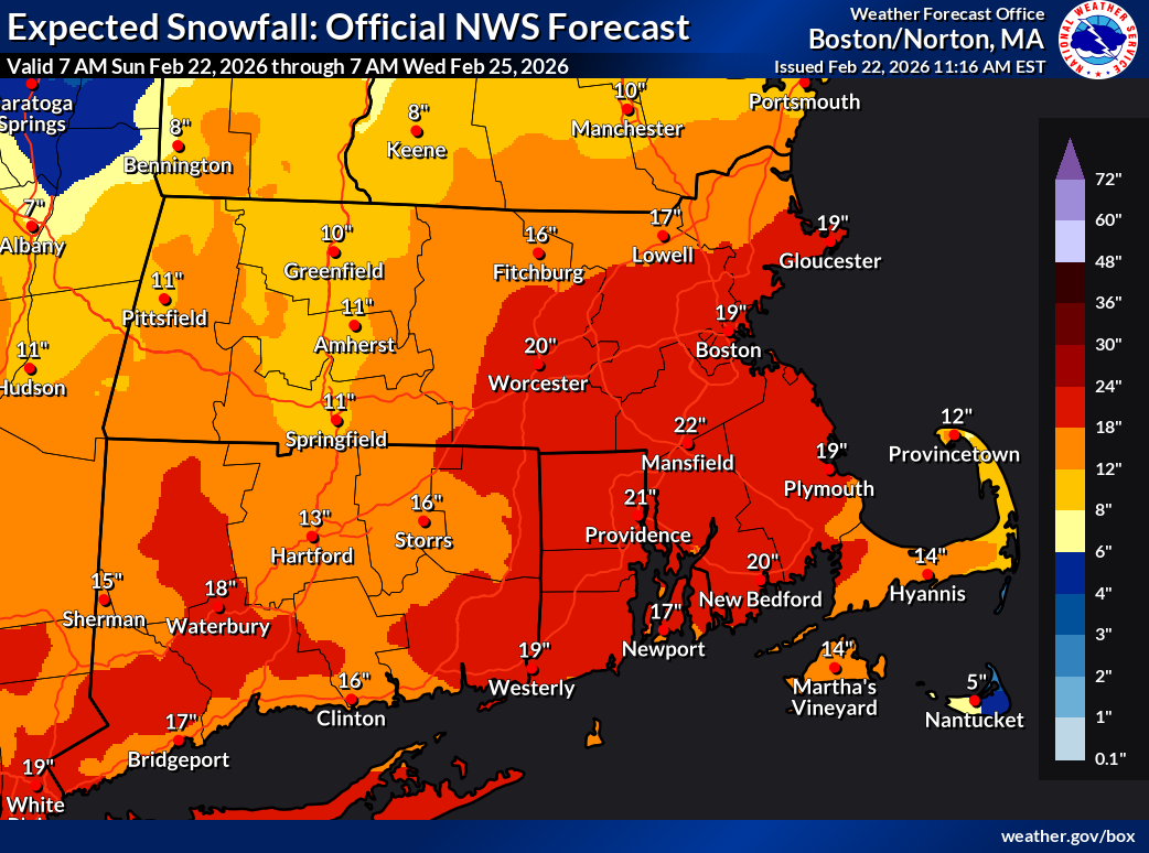
Snow totals will remain around 20 inches in southeast New England, with both Providence and Boston likely to come close to there. Lesser amounts will fall on Cape Cod and especially Nantucket. A secondary snowfall maximum for the event overall could occur between Providence and Boston.
That’s a lot of snow. This storm will be in a future edition of “Northeast Snowstorms” I am sure.
Powerful winds
The forecast wind gusts remain very impressive across the region, with coastal communities likely to see 50 to 70 mph wind gusts from New Jersey through Long Island and southeast New England.
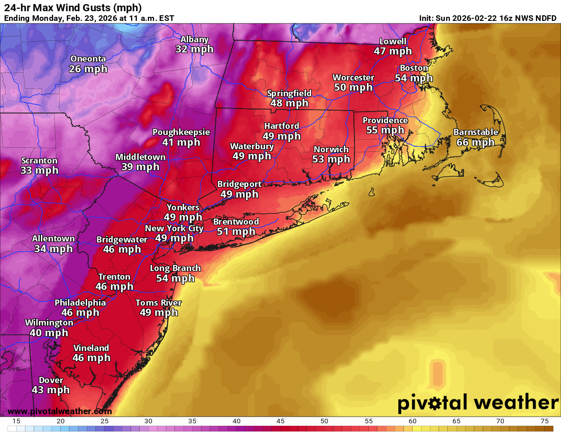
Hence, blizzard warnings are spread over a wide area for most areas south and east of I-84.
Coastal flooding
Tonight’s high tide is expected to cause locally major coastal flooding on the Delaware coast and Jersey Shore up through Long Island. Atlantic City is now forecast to see major tidal flooding levels reached. An 8-foot high tide would be the highest there since Hurricane Sandy.
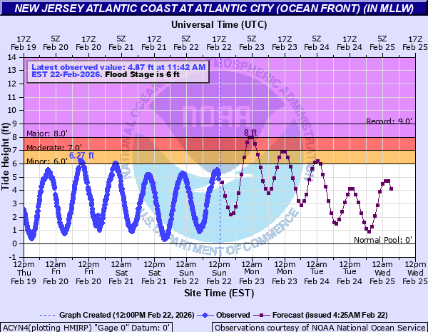
Widespread moderate tidal flooding will occur outside of those pockets of major flooding. Thankfully, the storm is moving away by tomorrow, so that should limit the number of elevated high tides we see, with mainly just tonight’s being the most troubling for the region.
And so now we wait and see the totals pile in. Here’s hoping everyone stays safe through this event in the East. Feel free to share your reports with us too!
Source link