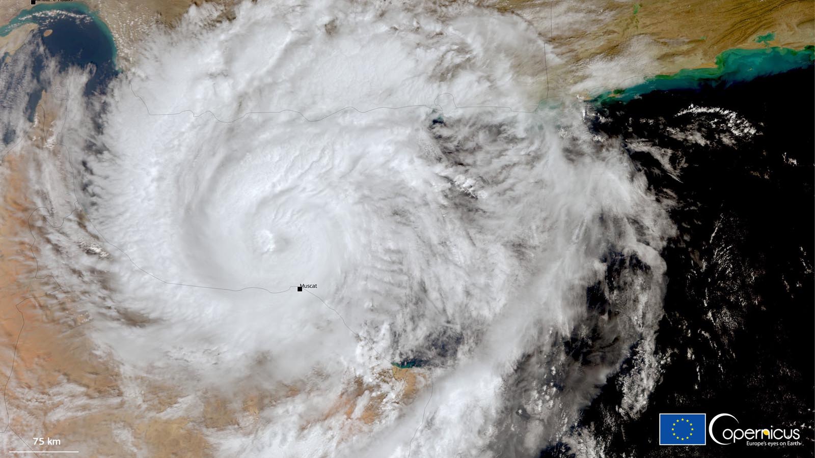
Cyclone Shaheen made weather history on Sunday evening, October 3, as it came onshore between Al Masnaah and Al-Suwaiq, Oman, about 50 miles west-northwest of the capital city of Muscat. The cyclone weakened from minimal Category 1 strength just before landfall, arriving with top sustained winds of 63 to 73 mph, according to the state news agency.
At least three deaths have been attributed to Shaheen, according to the Muscat Daily – a child who drowned in Al Amarat and two people killed in a mudslide in an industrial area of Muscat.
Shaheen has brought torrential rains and flash flooding to a desert climate, in some cases dumping a year’s worth of rain or more in a single day. Al Amarat, on the east side of the city of Muscat, received 136.6 millimeters (5.38 inches) of rain in the 24 hours ending at 8 a.m. EDT Sunday. Muscat’s Seeb International Airport recorded 73 millimeters (2.87 inches) in the 24 hours ending at 11 a.m. EDT Sunday. The average October rainfall for Muscat is 0.8 millimeters (0.03 inches), and the average yearly rainfall is 89.7 millimeters (3.59 inches).
Suwaiq, located near the coast in the strong right-front quadrant of Shaheen’s eyewall, recorded sustained winds of 52 mph at 12:08 p.m. EDT Sunday. Sustained winds of 36 mph and gusts to 51 mph were reported at Muscat International Airport at 5:50 a.m. Sunday as Shaheen approached.
Activity came to a standstill across Oman as a two-day national holiday was decreed for Sunday and Monday with the approach of Shaheen.
Shaheen is a relatively small tropical cyclone, its landfall well placed to keep the strongest winds away from the largest cities of northern Oman. The storm also dove toward the southwest sooner than predicted, reducing its time over the warm waters of the Gulf of Oman. Hurricane-force winds were limited to a radius of fewer than 20 miles from the center.
Shaheen will weaken rapidly as it moves inland, but as its circulation pushes southwest, it will encounter the high terrain of the Al Hajar Mountains, which will squeeze out torrential rains. Oman’s National Multi Hazard Early Warning Center warned of the potential for Shaheen to bring 200 to 500 millimeters of rain (8 to 20 inches).
The Joint Typhoon Warning Center used the name Cyclone Shaheen-Gulab for the storm, alluding to its origins in the Bay of Bengal a week ago as Cyclone Gulab. At least 20 deaths in India are being blamed on Gulab, which regrouped in the Arabian Sea on Thursday and was renamed Cyclone Shaheen by the India Meteorological Department.
How unusual is Shaheen?
Only a handful of tropical cyclones have been recorded in the Gulf of Oman, and none made it as far west as Shaheen did. The strongest, Cyclone Gonu, rampaged across the western Arabian Sea in June 2007 as a Category 5 equivalent – that sea’s strongest cyclone ever recorded. Gonu brushed the eastern tip of Oman before making landfall as a tropical depression in southern Iran, becoming that nation’s only tropical cyclone on record. Gonu caused more than $4 billion in damage, mainly in Oman, and led to at least 78 deaths. In 2010, Cyclone Phet followed a roughly similar track toward the eastern tip of Oman before angling further east. Phet caused more than $800 million in damage and 24 fatalities.
Even in this rarefied group, Shaheen was unique, crossing the Gulf of Oman from northeast to southwest. All other cyclones affecting the northern coast of Oman arrived from the south rather than from the gulf itself.
Shaheen fed off warm surface waters of the Gulf of Oman, where sea surface temperatures will increase from 29 to 31 degrees Celsius (84 to 88°F) along the storm’s path. The storm is benefiting also from unusually low wind shear, holding at 10 knots or less.
Hurricane Sam a major hurricane no longer
Hurricane Sam finally weakened below major hurricane strength on Sunday morning, ending a remarkable 7.75-day odyssey across the central Atlantic as one of the longest-lived major hurricanes on record. According to Phil Klotzbach of Colorado State University, Sam is tied with Hurricane Edouard of 1996 for fourth-most consecutive days as an Atlantic major hurricane since the satellite era began in 1966. Sam is also in the top-ten list of Atlantic hurricanes for the length of time at category 4 strength. Sam’s long life as a major hurricane was enabled by its relatively slow forward speed, avoidance of land areas, and warmer-than-average ocean waters.
At 11 a.m. EDT Sunday, Sam was a category 2 hurricane with 100-mph winds and a central pressure of 964 mb, headed northeast at 16 mph, and located about 625 miles south of Newfoundland. Beginning Sunday night, Sam will likely weaken significantly after it crosses the northern boundary of the Gulf Stream into much colder waters. Sam is expected to transition to a powerful hurricane-strength extratropical storm by Monday night. Sam’s long duration as a category 3 or stronger storm has made it a major wave machine, and the hurricane’s large swells will continue to affect portions of the Lesser Antilles, Greater Antilles, Bahamas, Bermuda, the U.S. East Coast, and the Canadian Maritime Provinces through Sunday, bringing high surf and dangerous rip currents.
Tropical Depression Victor barely hanging on to life
High wind shear and dry air associated with an upper-level trough of low pressure over the eastern Atlantic are continuing to rear at Tropical Depression Victor, which was barely hanging onto life as a tropical cyclone Sunday afternoon about 1,000 miles west of the Cabo Verde Islands. At 11 a.m. EDT Sunday, Victor, with top sustained winds of 35 mph, was still generating a patchy area of heavy thunderstorms, as seen on satellite images. By Monday, Victor is expected to be a remnant low pressure system.
Watching a disturbance over the Bahamas
An area of low pressure over the southeastern Bahamas was generating disorganized heavy rains on Sunday afternoon. The disturbance is expected to move west-northwestward at 10 mph through Monday, then turn northwest. By Thursday morning, this disturbance will likely bring rain to coastal North Carolina and South Carolina. The low has very limited model support for development, and is experiencing high wind shear of 20-30 knots, which is unfavorable for development. In its 2 p.m. EDT Sunday Tropical Weather Outlook, the National Hurricane Center gave the disturbance 2-day and 5-day odds of development of 10% and 20%, respectively.
Website visitors can comment on “Eye on the Storm” posts. Comments are generally open for 30 days from date posted. Sign up to receive email announcements of new postings here. Twitter: @DrJeffMasters and @bhensonweather
Source link