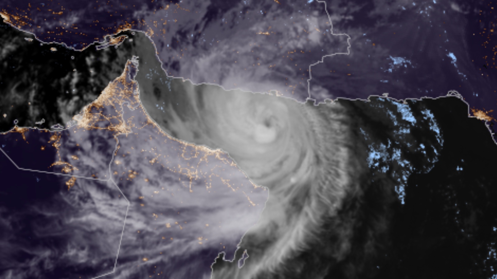
Cyclone Shaheen was on track Saturday to become the first tropical cyclone in modern recordkeeping to strike the northern coast of Oman, perhaps even moving into the United Arab Emirates before it dissipates. Destructive flash flooding, storm surge, and high winds are all possible. The Oman government declared a two-day national holiday for Monday and Tuesday to allow people to prepare for the storm.
This system brought gales and torrential rains to northeast India on Sunday as Cyclone Gulab, then disintegrated while crossing central India. At least 20 deaths in India are being blamed on the cyclone. Gulab regrouped in the Arabian Sea on Thursday, where it was renamed Cyclone Shaheen by the India Meteorological Department. The Joint Typhoon Warning Center is referring to the system as Shaheen-Gulab.
Shaheen’s top winds were at minimal Category 1 strength of 75 mph as of 11 a.m. Saturday, according to the JTWC. Shaheen was expected to continue to strengthen into Sunday as it feeds off warm surface waters of the Gulf of Oman, where sea surface temperatures will increase from 29 to 31 degrees Celsius (84 to 88°F) along the storm’s path. The storm is benefiting also from unusually low wind shear, holding at 10 knots or less.
The main impediments to Shaheen are interactions with land adjoining the Gulf of Oman, including parched desert air. However, it appears that a pocket of moist air walled off at the core of Shaheen may limit the impact of dry air.


Terra incognita for tropical cyclones
Only a handful of tropical cyclones have been recorded in the Gulf of Oman, and none as far west as Shaheen will track. The strongest, Cyclone Gonu, rampaged across the western Arabian Sea in June 2007 as a Category 5 equivalent – that sea’s strongest cyclone ever recorded. Gonu brushed the eastern tip of Oman before making landfall as a tropical depression in southern Iran, becoming that nation’s only tropical cyclone on record. Gonu caused more than $4 billion in damage, mainly in Oman, and led to at least 78 deaths. In 2010, Cyclone Phet followed a roughly similar track toward the eastern tip of Oman before angling further east. Phet caused more than $800 million in damage and 24 fatalities.
Even in this rarefied group, Shaheen is an outlier, approaching the Gulf of Oman from the east instead of from the south.


Forecast for Shaheen
The Joint Typhoon Warning Center predicted on Saturday that Shaheen would move west-northwest and then arc toward the west-southwest into the Gulf of Oman, making landfall well to the west of Oman’s capital city, Muscat, on Sunday night local time as a category 2-strength cyclone with 100-mph winds. Landfall may occur near the city of Sohar (pop. 200,000), where one of the world’s largest and fastest-growing port development projects is under way.
Shaheen could dump torrential rains atop normally dry terrain, producing dangerous flash floods. The rains will be exacerbated as the circulation of Shaheen pushes upslope against the Al Hajar Mountains in far northwest Oman. The concave geography of these mountains may enhance Shaheen’s cyclonic flow as the storm approaches, and the similarly concave coastline may accentuate storm surge.
Oman’s National Multi Hazard Early Warning Center warned of the threats of severe flash flooding, winds of 45 to 70 mph, coastal storm surge, and enormous waves of up to 8-12 meters (26-39 feet). The center said that parts of northwest Oman could receive 200 to 500 millimeters of rain (8 to 20 inches). For perspective, Sohar’s average annual rainfall is only 4.28 inches, and virtually no rain falls there from June through October.
Could the Persian Gulf ever get a hurricane?
The HWRF model has been exceptionally bullish on Shaheen, indicating for several runs on Friday and again in its 12Z Saturday run that the storm could make landfall as a category 3 equivalent. Two HWRF runs on Friday even suggested that Shaheen could go on to reintensify in the southernmost Persian Gulf and strike Qatar, although the model now agrees with its peers that Shaheen is more likely to dissipate over the United Arab Emirates after its landfall in Oman.
Sea surface temperatures warm dramatically as one moves toward the western Gulf of Oman and the Persian Gulf, where the water is protected from mixing and exposed to fierce subtropical summer sun. Despite this fuel for tropical cyclones, none has ever been recorded in the Persian Gulf, mainly because of persistent wind shear and dry air. However, the idea was explored in “Grey swan tropical cyclones”, a fascinating study by Ning Lin and Kerry Emanuel published in Nature Climate Change in 2015. By “seeding” the region’s observed climate of 1980-2010 with 3100 weak, randomly positioned tropical cyclones, then modeling those cyclones, the authors found that at least two grew to formidable strength in the Persian Gulf, including one stronger than any observed on Earth to date!
The authors wrote: “Although tropical cyclone development is limited in the Persian Gulf, a large threat exists and may be very sensitive to changes of the atmospheric circulation in the region….Further warming of the ocean may further increase the chance of the Persian Gulf region being struck by an extreme storm.”
Sam enters its second week as a major hurricane
Hurricane Sam continues to hold its own as a powerful category 4 storm in the central Atlantic, well away from any land areas. As of Saturday, Sam had completed an entire week at major hurricane strength (Cat 3 or stronger), a feat only six other Atlantic hurricanes have managed since accurate satellite data began in 1966. Sam was also in the top-ten list of Atlantic hurricanes for the length of time at category 4 strength.
At 11 a.m. EDT Saturday, Sam was a low-end category 4 hurricane with 130 mph winds and a central pressure of 945 mb, headed northeast at 17 mph. Sam made its closest approach to Bermuda early Saturday morning, passing 210 miles to the east of the island. Sam has increased in size this week, with the radius of hurricane-force winds expanding from 30 miles on Monday morning to 65 miles on Saturday morning, and the radius of tropical storm-force winds growing from 105 to 240 miles.
Sam’s long duration as a category 3 or stronger storm has made it a major wave machine, and the hurricane’s large swells will continue to affect portions of the Lesser Antilles, Greater Antilles, Bahamas, Bermuda, the U.S. East Coast, and the Canadian Maritime Provinces through Sunday, bringing high surf and dangerous rip currents.
Sam headed out to sea
Sam likely will hold its own as a potent category 3 or 4 hurricane until at least Sunday afternoon as it moves steadily northeast and accelerates. By Monday, Sam will likely weaken significantly after it crosses the northern boundary of the Gulf Stream into much colder waters. Sam is expected to transition to a powerful hurricane-strength extratropical storm on Tuesday.
Tropical Storm Victor nears its demise
After encountering high wind shear and dry air associated with an upper-level trough of low pressure over the eastern Atlantic, Tropical Storm Victor is nearing the end of its time as a tropical cyclone. At 11 a.m. EDT Saturday, Victor, with top sustained winds of 40 mph, had lost nearly all its heavy thunderstorms, as seen on satellite images. By Saturday night, Victor is expected to be a remnant low pressure system.
Website visitors can comment on “Eye on the Storm” posts. Please read our Comments Policy prior to posting. Comments are generally open for 30 days from date posted. Sign up to receive email announcements of new postings here. Twitter: @DrJeffMasters and @bhensonweather
Source link