At least 13 deaths have been attributed to Tropical Cyclone Shaheen, which made landfall late Sunday night, October 3, near Al Suwaiq, about 75 miles west-northwest of the Omani capital city of Muscat. Shaheen was the first cyclone on record to enter the Gulf of Oman from the east and strike the north coast of Oman. Shaheen had weakened from minimal Category 1 strength just before landfall, arriving with top sustained winds of 55 knots (63 mph), according to the Joint Typhoon Warning Center. Al Suwaiq recorded sustained winds of 52 mph at 12:08 p.m. EDT Sunday, October 3.
Omani authorities reported 11 deaths in Oman, BBC reported, and two fishermen were found dead in Iran. Two of the Omani deaths were in a house destroyed by a mudslide. Videos on social media showed multiple motorists caught in high water.
The dramatic video below, from Oman’s National Committee for Emergency Management, shows a rescue in a wadi (a normally dry river channel) just inland from the coastal community of Al Suwayq, near where Shaheen made landfall.
Shaheen’s winds at landfall were weaker than had been predicted, as a leftward turn brought Shaheen onshore sooner than expected, giving it less time to intensify. The turn spared the major shipping port of Sohar, where normal operations had resumed by Monday, according to the Muscat Daily.
Incredible rainfall reported
Shaheen brought torrential rains and flash flooding to a desert climate, in some cases dumping a year’s worth of rain or more in a single day. Al Suwaiq picked up an astounding 294.2 millimeters (11.58 inches) in the 48 hours starting at 8 a.m. EDT Saturday, October 1, with 279.4 mm (11.00 in) in the 24 hours starting at 8 a.m. EDT Sunday. Other impressive two-day storm totals through 8 a.m. Monday were 146.8 mm (5.78 in) at Al Amarat, just south of Muscat, and 94.6 mm (3.72 in) at Muscat International Airport in Seeb. For perspective, the average October rainfall for Muscat is 0.8 millimeters (0.03 inches), and the average yearly rainfall is 89.7 millimeters (3.59 inches).
The Joint Typhoon Warning Center used the name Cyclone Shaheen-Gulab for the storm, alluding to its origins in the Bay of Bengal. At least 20 deaths in India were blamed on Gulab, which regrouped in the Arabian Sea on September 30 and was renamed Cyclone Shaheen by the India Meteorological Department.
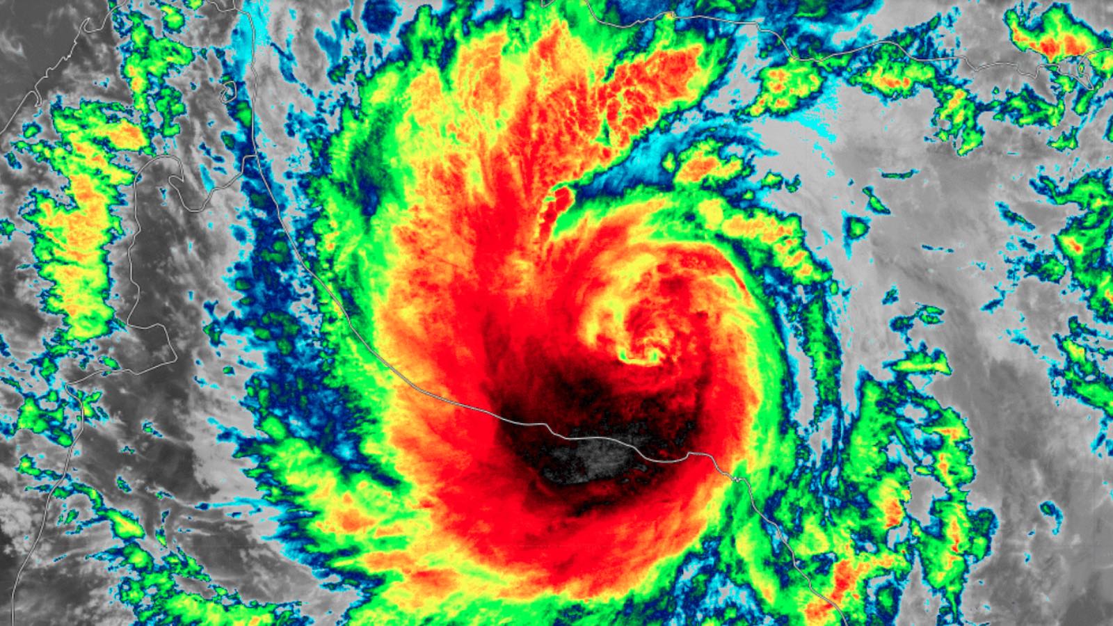
How unusual was Shaheen?
Only a handful of tropical cyclones have been recorded in the Gulf of Oman, and none made it so far west as Shaheen did. The strongest, Cyclone Gonu, rampaged across the western Arabian Sea in June 2007 as a Category 5 equivalent – that sea’s strongest cyclone ever recorded. Gonu brushed the eastern tip of Oman before making landfall as a tropical depression in southern Iran, becoming that nation’s only tropical cyclone on record. In 2010, Cyclone Phet followed a roughly similar track toward the eastern tip of Oman before angling further east.
Even in this rarefied group, Shaheen was unique, crossing the Gulf of Oman from northeast to southwest. All other cyclones affecting the northern coast of Oman arrived from the south rather than from the gulf itself. Shaheen fed off warm surface waters of 29-30 degrees Celsius (84-86°F) as well as unusually low wind shear, which typically quashes tropical cyclones in the gulf by driving parched desert air into their circulations.


Sam continues to churn the North Atlantic
Long-lived Hurricane Sam will remain a potent storm this week as it rages across the far north Atlantic, but not as a hurricane: Sam will be morphing into a post-tropical cyclone by Monday night or Tuesday. At 11 a.m. Monday, Sam was still a Category 2 hurricane with 100-mph sustained winds, centered almost 500 miles southeast of Newfoundland.
As Sam encountered a warm eddy along the Gulf Stream late Sunday, its top winds briefly notched up to 105 mph, an unusual burst of strength given Sam’s latitude. “It is not every day you see a hurricane with that clear of an eye near 40N,” said National Hurricane Center hurricane specialist Eric Blake in a forecast discussion.
Sam weakened below major hurricane strength on Sunday morning, ending a remarkable 7.75-day odyssey across the central Atlantic as one of the longest-lived major hurricanes on record. According to Phil Klotzbach of Colorado State University, Sam is tied with Hurricane Edouard of 1996 for fourth-most consecutive days as an Atlantic major hurricane since the satellite era began in 1966.
Victor is no more
High wind shear and dry air over the eastern Atlantic brought an end to former Tropical Storm Victor, which was declared a remnant trough of low pressure with no closed circulation at 11 a.m. EDT Monday in a final advisory from the National Hurricane Center.
Disturbance over the Bahamas unlikely to develop
An area of low pressure over the southeastern Bahamas continued to generate disorganized heavy rains on Monday afternoon. The disturbance is expected to move northwest over the next several days, likely bringing rain to coastal North Carolina and South Carolina by late in the week. The low has very limited model support for development, and is experiencing high wind shear of 20-30 knots, which is unfavorable for development. In its 2 p.m. EDT Monday Tropical Weather Outlook, NHC gave the disturbance 2-day and 5-day odds of development of near 0% and 10%, respectively.
Website visitors can comment on “Eye on the Storm” posts. Comments are generally open for 30 days from date posted. Sign up to receive email announcements of new postings here. Twitter: @DrJeffMasters and @bhensonweather
Source link