After leveling out in intensity on Friday upon attaining category 1 hurricane strength, Hurricane Sam put on an impressive burst of rapid intensification overnight, reaching major hurricane status at 11 a.m. EDT Saturday. Sam is expected to be a powerful long-track Cape Verde-type hurricane that could threaten Bermuda late next week. Sam is not expected to directly impact the Leeward Islands, and it will most likely recurve too far east to make landfall on the U.S. East Coast. The Maritime Provinces of Canada could see impacts from Sam by next weekend, though.
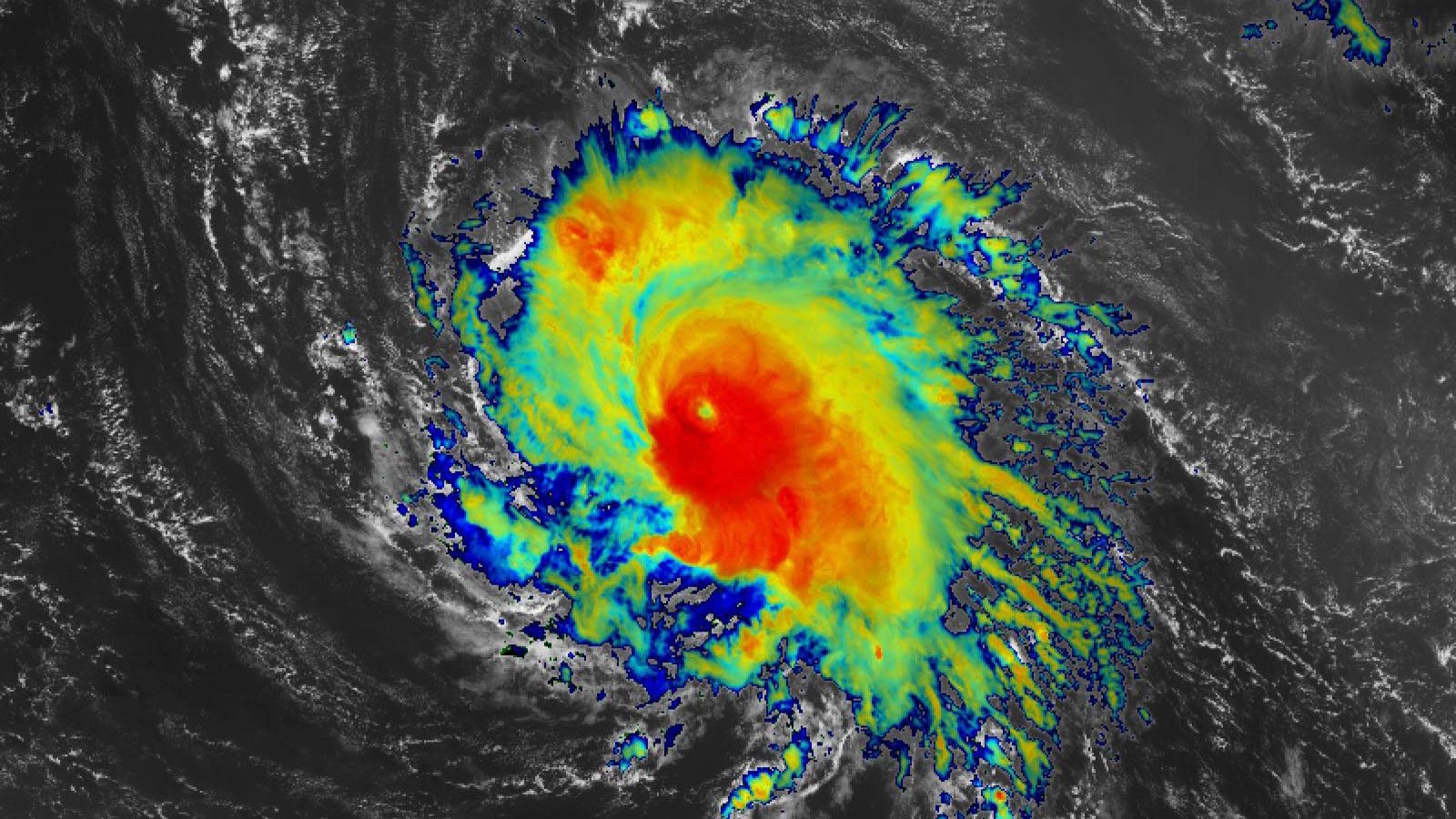
At 11 a.m. Saturday, Sam was in the central tropical Atlantic about 1,095 miles east-southeast of the northern Leeward Islands, headed west-northwest at 10 mph with top winds of 120 mph and a central pressure of 960 mb. Satellite images showed an impressive storm with a concentrated area of heavy thunderstorms with cold cloud tops surrounding a well-defined eye.
Six of this year’s seven hurricanes have intensified by at least 35 mph in 24 hours – the National Hurricane Center’s definition of rapid intensification. Only Henri did not do so:
Sam: 45 mph ending 15Z Sep. 25;
Nicholas: 35 mph ending 3Z Sep. 14;
Larry: 45 mph ending 3Z Sep. 4;
Ida: 65 mph ending 15Z Aug. 29;
Grace: 55 mph ending 6Z Aug. 21; and
Elsa: 35 mph ending 12Z Jul. 2.
Intensity forecast for Sam
Sam has good model support for continued intensification, and conditions appear quite favorable for it to intensify throughout the next two days. Wind shear is predicted to be light (5-10 knots), and sea surface temperatures (SSTs) will be 28.5-29 degrees Celsius (83-84°F). The atmosphere is predicted to be on the dry side, though, with a mid-level relative humidity of 50-60%. The NHC forecast calls for Sam to peak as a category 4 storm with 140 mph winds on Sunday night and Monday. An eyewall replacement cycle, common in major hurricanes, is a good bet to interrupt the current intensification cycle by Monday. The 12Z Saturday run of the SHIPS model gave a 0% chance that Sam would intensify into a 160-mph category 5 hurricane by Sunday morning; the experimental DTOPS model gave that prospect a 5% chance of occurring.
Tuesday through Thursday, Sam will likely encounter less favorable conditions for intensification, with wind shear rising to a moderate 10-15 knots, and the atmosphere surrounding the storm remaining dry. Sam is a small hurricane, and small storms are more prone to rapid changes in strength, so it would not be a surprise to see Sam fluctuate in strength by 10-20 mph during the week as a result of eyewall replacement cycles or ingestion of dry air.


Track forecast for Sam
Sam is predicted to track west-northwest to northwest around 10 mph over the next five days and pass 100-200 miles northeast of the Leeward Islands on Thursday. The islands are expected to avoid Sam’s tropical storm-force winds, but could see a few heavy rain showers from Sam’s outer spiral bands. These islands were just outside the NHC’s 5-day cone of uncertainty as of the 11 a.m. EDT Saturday advisory.
A strong trough of low pressure passing to the north of Sam will cause the hurricane to turn to the north and accelerate by Thursday, bringing it within several hundred miles of Bermuda next Friday or Saturday. Sam could be a threat to the Canadian Maritime Provinces on Saturday and Sunday, but it is impossible to judge this threat with any confidence so far in advance. It is also too soon to rule out a potential threat to the Northeast U.S., as there is a possibility that an East Coast upper-level trough of low pressure could dive far enough south to pull Sam northwestward.
The first hurricane hunter mission into Sam is scheduled for Sunday morning.
Subtropical Storm Teresa short-lived
Subtropical Storm Teresa formed at 5 p.m. EDT Friday, September 24, a few hundred miles northeast of Bermuda. However, cool waters, dry air, and higher wind shear weakened Teresa to a tropical depression at 11 a.m. Saturday, and the system is expected to be a remnant low by Saturday night or Sunday. Teresa is the type of weak, short-lived storm that would likely not have been given a name in the pre-satellite era.
Atlantic likely to run out of names for 2nd year in a row
Teresa was the 19th named storm of 2021, and according to Phil Klotzbach of Colorado State University, only one other season has had as many as 19 named storms by September 24: 2020. In that insanely active year, we’d already burned through the full list of 21 names by September 24, and were two letters into the Greek alphabet (Beta). So far in 2021, the Atlantic has had 19 named storms, seven hurricanes, and four major hurricanes. The 1991-2020 averages for an entire season were 14.4 named storms, 7.2 hurricanes, and 3.2 major hurricanes.
On average, we can expect to see five to six more named storms, two to three more hurricanes, and one additional major hurricane after September 25. This makes it very likely that we will run through the full list of 21 names in the Atlantic for the second year in a row. Only two names remain in the 2021 list: Victor and Wanda. The 22nd named storm of 2021 would be called Adria, as the season cycles through a new alphabetical list of 21 supplemental names (naming storms after Greek letters has been permanently discontinued).
New tropical wave expected to emerge from coast of Africa Monday
A new tropical wave is expected to emerge from the coast of Africa by Monday morning. This wave has strong model support for development after it emerges from the coast and moves west at 10-15 mph over the eastern tropical Atlantic. In its 8 a.m. EDT Saturday Tropical Weather Outlook, the NHC gave the wave 2-day and 5-day odds of development of 0% and 50%, respectively.
The NHC also is watching the remnants of Tropical Storm Peter several hundred miles south of Bermuda for regeneration. In its 8 a.m. EDT Saturday Tropical Weather Outlook, the NHC gave ex-Peter 2-day and 5-day odds of development of 10% and 20%, respectively.
There were two other tropical cyclones active worldwide on Saturday (see Tweets below): category 4 Typhoon Mindulle, expected to recurve east of Japan, and Tropical Cyclone Gulab, expected to hit India’s Bay of Bengal coast on Sunday as a tropical storm.
Bob Henson contributed to this post.
Website visitors can comment on “Eye on the Storm” posts. Please read our Comments Policy prior to posting. Comments are generally open for 30 days from date posted. Sign up to receive email announcements of new postings here. Twitter: @DrJeffMasters and @bhensonweather
Source link