Millions of people along the populous southeast coast of China were bracing on Thursday night for powerful Typhoon Doksari. According to the Joint Typhoon Warning Center, Doksari was packing sustained winds of 120 mph as of 11 a.m. EDT Thursday, making it the equivalent of a category 3 hurricane. Doksuri was predicted to arrive on Friday local time in the vicinity of Xiamen, a major port city with a metro area of around 7 million.
As it nears the coast, Doksuri will pass over extremely warm sea surface temperatures of 31-32 degrees Celsius (88-90 degrees Fahrenheit), and the storm will be ventilated by a strong upper-level outflow jet. These factors may allow Doksuri to at least maintain its category 3 strength prior to landfall and perhaps arrive as a category 4 storm.
Doksuri brought torrential rains and serious flooding to the northwest part of the Philippines’ Luzon island as it slowly passed just north of the island from Wednesday into Thursday. At least eight deaths were reported from the high winds and floods of Doksuri (which was dubbed Egay in the Philippines), including four who died in a house struck by a landslide. Strong winds extended well south into central Luzon, where at least 20 people died as a passenger boat capsized in gusty conditions just east of Manila. Torrential rains also pounded much of southern and eastern Taiwan as Doksuri passed well to the south.
A surprisingly potent rebound
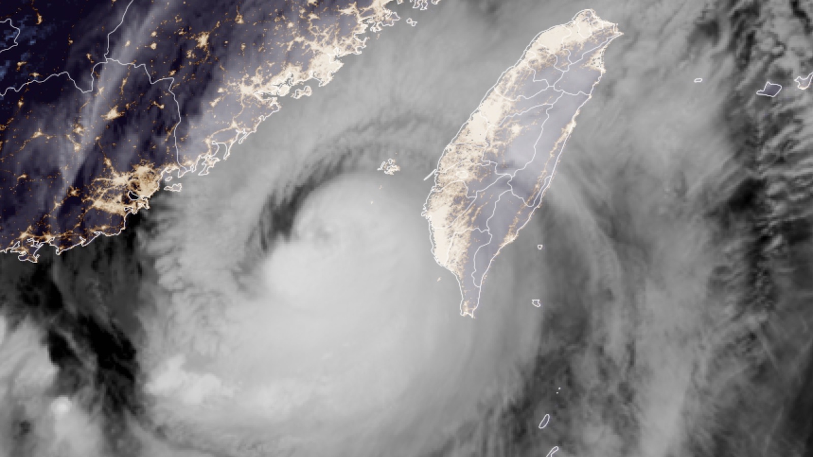
After weakening from category 4 to category 1 strength while near the Philippines, Doksari embarked on an unexpectedly strong round of rapid intensification over the warm waters of the South China Sea. The strengthening occurred in the midst of an attempted eyewall replacement cycle, a process that more often leads to short-term weakening. “The system has undergone what is frankly an incredible metamorphosis in a very short period of time,” marveled the Joint Typhoon Warning Center on Thursday.
The most spectacular aspect was Doksari’s double eyewall structure, with a tight eye only about 5 miles across, a secondary eyewall more than 100 miles wide, and a “moat” in between. This unusually wide moat may have enabled Doksari’s innermost core to behave like a much smaller typhoon, allowing it to intensify more quickly than usual. By the same token, the inner core could decay quickly as the outer eyewall contracts around it. In any event, Doksuri’s broad circulation will bring an expansive area of heavy rain and potentially damaging wind to the heavily populated China coast.
Should Doksuri manage to reach China at category 4 strength, it would join a select club. The lengthy, populous east coast of China has seen only a dozen landfalling typhoons of at least category 4 strength in modern records. Just two of those were category 5s, most recently Rammasun (2014). Powerful typhoons tend to either recurve before reaching China or weaken en route to the coast, especially if they interact with the mountainous landscapes of the Philippines and Taiwan.
Another strong typhoon may follow Doksuri toward China
People on the China coast will also need to pay close attention to Tropical Depression 6W, which is slowly organizing in the Northwest Pacific. With a warm sea surface and light wind shear ahead of it, 6W is predicted to rapidly intensify in the next several days, becoming a typhoon as soon as Saturday. By early next week, a broad upper-level high will likely force 6W to angle toward the northwest and west, perhaps bringing it into the central coast of China around Tuesday.
One disturbance to watch in the Atlantic
A tropical wave located a few hundred miles west-southwest of the Cabo Verde Islands is predicted to speed west-northwest across the tropical Atlantic at about 15-20 mph during the next five days. By Monday, July 31, the wave is expected to be several hundred miles northeast of the Leeward Islands, and there is some support for development around that time from a number of members of the GFS and European model ensembles, as well as the 6Z Thursday operational version of the GFS model. These models predict that Bermuda is likely to be the only land area threatened by the system next week. In its 2 p.m. EDT Thursday Tropical Weather Outlook, the National Hurricane Center gave the disturbance two-day and seven-day odds of development of near zero and 40%, respectively.
Website visitors can comment on “Eye on the Storm” posts (see comments policy below). Sign up to receive notices of new postings here.
Source link