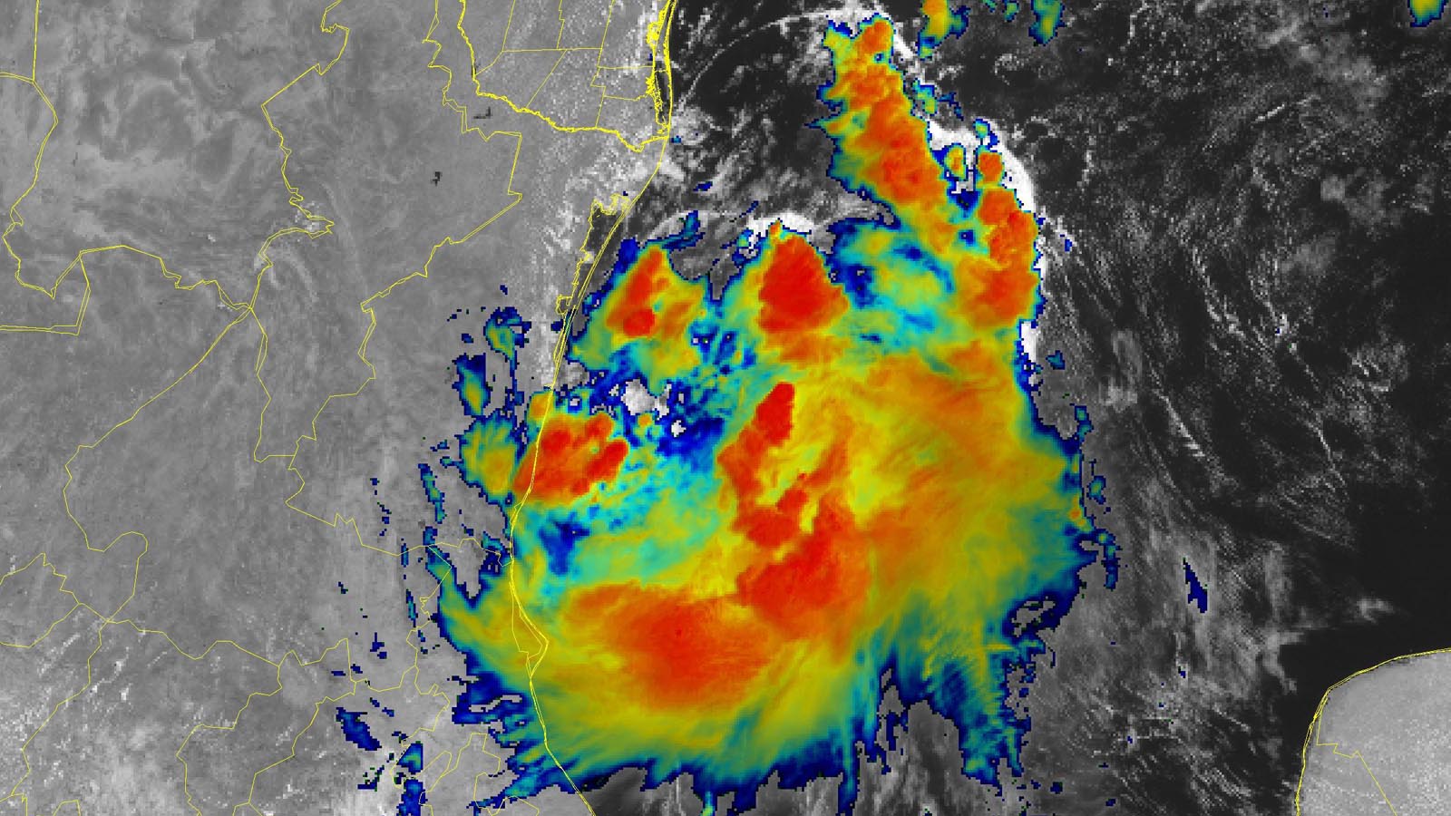
A tropical disturbance in the western Gulf of Mexico designated Potential Tropical Cyclone Four (PTC 4) by the National Hurricane Center, NHC, remained disorganized at midday Saturday, but with the potential to organize into a short-lived tropical storm before moving inland just south of the Texas/Mexico border by Saturday night.
At 11 a.m. EDT Saturday, the disturbance was headed northwest at about 13 mph. The system had somewhat favorable conditions for development, with sea surface temperatures near 30 degrees Celsius (86°F), moderate wind shear of 15-20 knots, and a moderately moist atmosphere (a mid-level relative humidity of 65%). However, satellite images on Saturday afternoon showed that dry air on the north side of PTC 4 was being driven into the core of the system, resulting in telltale arc-shaped surface clouds that raced outward, a sign of PTC 4’s thunderstorms collapsing from dry air intrusions, robbing the system of moisture and energy. A hurricane hunter mission late Saturday morning found a broad area of calm winds near the center of PTC 4, but no signs of an organized surface circulation.
Steering currents favor a northwesterly track, which will take PTC 4 inland over northeastern Mexico by Saturday night. In it’s 11 a.m. EDT Saturday advisory, the NHC gave PTC 4 two-day and five-day odds of formation of 60%.
The next name on the Atlantic list of storms is Danielle, one of the most recycled names on the rotating list of storms, with seven previous incarnations of Danielle, beginning in 1980.


The main hazard from PTC 4 will be flooding from heavy rains. However, the system’s rains will be more boon than bane, with the heaviest rains falling over northeastern Mexico, which is experiencing moderate to severe drought. Beneficial rains from PTC 4 will also push into southern Texas, where severe drought conditions were helped early this week by heavy rains from an earlier tropical disturbance, 98L.
From drought to deluge: A classic transition ahead for North Texas
PTC 4 may also contribute to even heavier rains across northern Texas long after the system pushes inland. A slug of rich moisture, with precipitable water values between 2 and 2.5 inches, will be hauled into Texas on the east side of PTC 4. It will there join up with some of the energy and moisture still spinning around tropical disturbance 98L, which made landfall early in the week over South Texas. Although 98L never developed as it crossed the western Gulf, it managed to hold together as a surprisingly coherent low on its inland trek this past week, moving along the U.S./Mexico border all the way from the Rio Grande Valley to the Gulf of California.
By late in the weekend, some remnants of PTC 4 and 98L will join forces over northern Texas, reinforcing a weak east-west frontal zone near the tail end of an upper-level trough and concentrating moisture there. The result will be several days of very heavy rainfall across this drought-parched region. The corridor of heaviest rain likely will be centered at first in a broad zone near the Dallas-Fort Worth area, gradually shifting south toward the Austin-San Antonio area by later in the week. The details will hinge on hard-to-predict small-scale features.
The NOAA/NWS Weather Prediction Center is predicting one-week rainfall totals from August 20 to 25 in excess of five inches over a sizable chunk of northern Texas (see Figure 1), most of that falling early in the week. The wettest three-day periods in Dallas-Fort Worth include a record 10.73″ April 24-26, 1922. More recently, 8.34″ fell September 20-22, 2018, fueled by the remnants of Tropical Depression 19-E from the East Pacific.


More than one gully-washer will be needed to erase the huge rainfall deficits racked up across Texas. More than 60% of the state was covered by extreme to exceptional drought as of Tuesday, August 16, according to the U.S. Drought Monitor. Over 15 inches of precipitation falling over the next month is needed to bring most of Texas out of long-term drought conditions (Figure 2), and portions of the state require over 20 inches of precipitation to break the drought. The coming week’s rains will surely help – but some localized flash flooding is possible.
Time to watch the eastern Atlantic
August 20 is the typical start of the peak portion of the Atlantic hurricane season, when tropical waves rolling off the coast of Africa near the Cabo Verde Islands need to be watched for development. One such wave is expected to leave the coast of Africa by Saturday night. The wave will move west-northwest to northwest at 15-20 mph over the next five days, and into the central tropical Atlantic, where dry air will likely be a problem for it. Waves in this location typically recurve out to sea without affecting the Caribbean or North America. In an 8 a.m. EDT Saturday Tropical Weather Outlook, the NHC gave this newly emerging wave two-day and five-day odds of formation of 0% and 20%, respectively.
Bob Henson contributed to this post. Website visitors can comment on “Eye on the Storm” posts (see comments policy below). Sign up to receive notices of new postings here.
Source link