An upper-level disturbance stalled over the subtropical North Atlantic about 800 miles northeast of the northern Leeward Islands is stimulating development of what may become a subtropical or even a tropical storm around midweek. Such an occurrence would be unusual but not unprecedented for December, even with the Atlantic hurricane season having officially ended on November 30.
In a special outlook issued at 8:45 a.m. EST Tuesday, December 6, the National Hurricane Center (NHC) gave this system – designated as Invest 99L and located near latitude 25 degrees north and longitude 55 degrees west – a 50% chance of developing into a subtropical or tropical cyclone over the next two days. The five-day odds are also 50%, which implies that any development would most likely happen by Thursday.
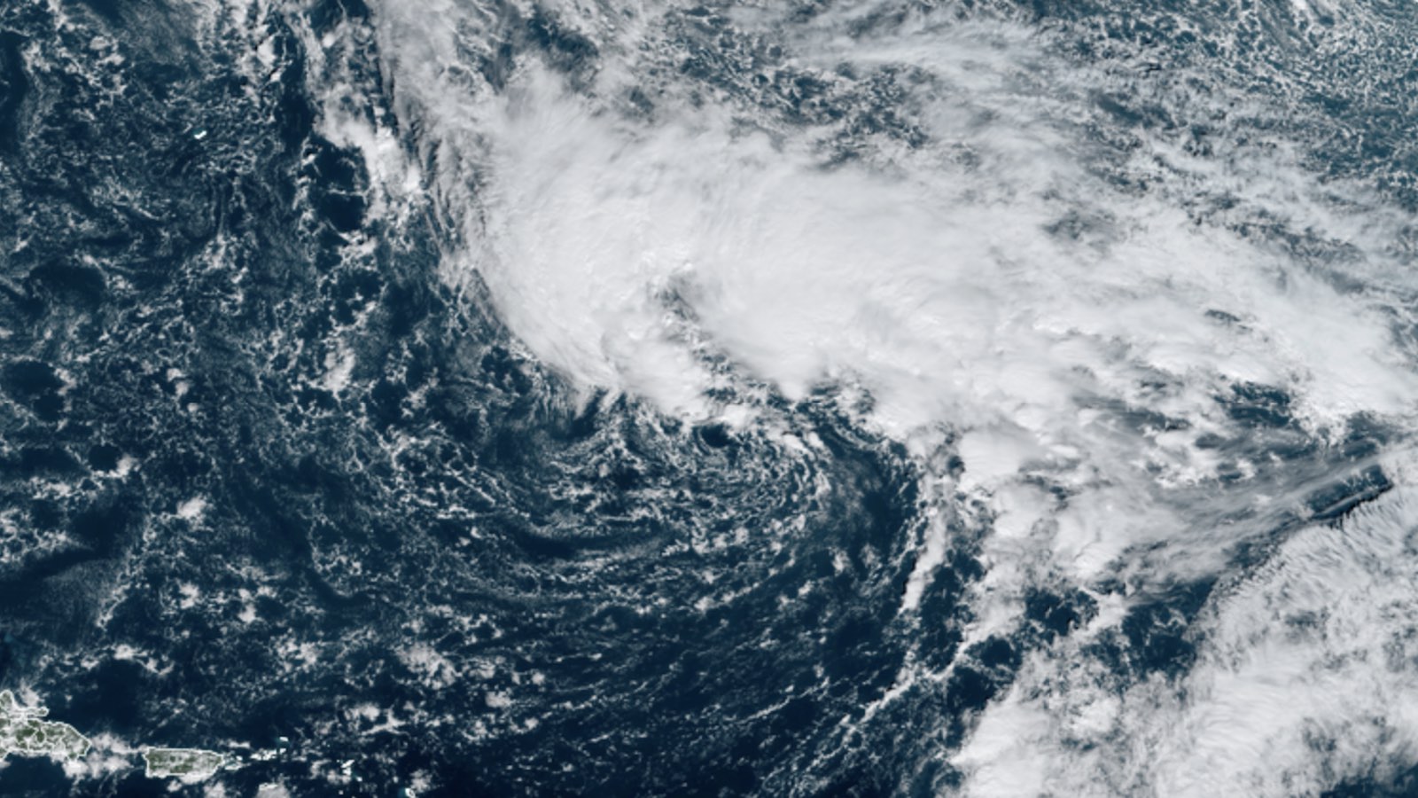
At midday Tuesday, satellite images showed 99L taking on the comma-shaped structure typical of a strengthening subtropical or extratropical cyclone. An extensive field of showers and thunderstorms extended entirely to the north of a center that was becoming better defined.
Helping the incipient system develop is a perennial feature of 2022: unusually warm water temperatures over the subtropical Atlantic. Sea surface temperatures (SSTs) in the vicinity of 99L on Tuesday were running around 27 degrees Celsius (91 degrees Fahrenheit), which is about 1 degree Celsius above average and just above the traditional minimum benchmark of 26°C for tropical development. Over the next day or so, 99L is expected to remain fairly close to these supportive waters, in part because of massive blocking further to the north: an exceptionally strong upper-level high extends from the far north Atlantic into Greenland.
Wind shear is fierce over 99L – more than 40 knots – so the most likely course of development would be for 99L to become a subtropical rather than a tropical storm. However, the phase-space forecast tool from Florida State University indicates that 99L could go through a brief period as a symmetric warm-core low, implying it could be more tropical than subtropical during that time. By late in the week, 99L is expected to evolve into a more typical mid-latitude storm system, albeit a very strong one for its latitude. Monday night GFS and European operational model runs show the central pressure of 99L dipping below 970 millibars by Friday, below 960 mb by Friday night, and near or below 950 mb by Saturday. If 99L does get designated as a tropical storm, it’s not out of the question it could attain hurricane strength before transitioning to post-tropical status.
Fortunately, as 99L begins to accelerate northeast by the weekend, it will remain far from any populated areas. The highest chance of any impacts would be to the islands of the Azores, which could experience gusty winds and high surf as 99L passes just to their west over the weekend.
History of named Atlantic systems in December
According to NOAA’s hurricane history database, 23 December named storms have occurred since 1851, an average of one every 7 – 8 years (some of these storms formed in November but lasted into December). Most recent was an unnamed tropical storm that spun over the central Atlantic December 3 – 7, 2013.
Only five December Atlantic tropical storms – and no hurricanes – have hit land. The deadliest December tropical cyclone on record was Tropical Storm Olga, which made landfall near Punta Cana, Dominican Republic, on December 11, 2007. Flooding from Olga’s rains killed 40 people – 37 in the Dominican Republic, two in Haiti, and one in Puerto Rico. Most of the deaths in the Dominican Republic occurred in its second largest city, Santiago, when water was released from the Taveras dam upstream of the city in order to keep the dam from failing. The only other December killer storm on record was Tropical Storm Odette, a 65-mph tropical storm that killed eight people in the Dominican Republic on December 7, 2003.
Heads up: serious severe weather possible next week
A strong upper-level impulse projected to intensify as it approaches the Southern Plains may trigger some noteworthy severe weather early next week. On Tuesday, the Storm Prediction Center highlighted an area centered on the Arklatex region (the intersection of Texas, Arkansas, and Louisiana) in its Day 7 severe weather outlook valid on Monday, December 12. It’s quite unusual for SPC to tag an area this far in advance during December. For comparison, the two historic outbreaks of last December—the catastrophic tornado outbreak of December 10-11 and the immense tornado swarm and derecho of December 15—were not highlighted until Day 3.
The Day 7 notice was prompted by close agreement between the GFS and European models in a favorable severe-weather setup around next Monday. Warm, moist air is entrenched over the Gulf of Mexico, already extending into the South and Southeast on Tuesday, so instability should be in place well before the arrival of the intensifying upper-level feature. The Day 7 outlook is too far out to know how intense and/or widespread any outbreak might be, but predictability at the long range is often strong for the most serious outbreaks, so people across the Southern Plains should keep severe weather in mind for early next week.
Website visitors can comment on “Eye on the Storm” posts (see comments policy below). Sign up to receive notices of new postings here.
Source link