The final phase of the Great U.S. Pre-Holiday Storm of 2022 kicked in on Friday, December 23, one of the year’s busiest travel days. Frigid air blanketed most of the northern, central, and eastern United States, wrapping around an intensifying winter storm in southeast Canada.
The storm was producing one of the biggest flood events in Lake Erie history and paralyzed the Buffalo, New York, area, closing the international bridge between the U.S. and Canada.
Winds atop Mount Washington, New Hampshire, gusted to 147 mph at 8:10 a.m. EST Friday. Both ahead of and behind the Arctic front, fierce winds knocked out power to many in the Mid-Atlantic and Northeast and triggered major coastal flooding in New England.
As of Friday afternoon, Poweroutage.com reported outages affecting more than 1.5 million customers in the United States and nearly 400,000 in Canada.
Parts of the Pacific Northwest were grappling with sheets of ice left by freezing rain on Friday, as Pacific moisture flowed atop persistently cold surface air.
Even where snowfall had stopped across the Midwest, high winds continued to generate blizzard and near-blizzard conditions in many areas.
One prime-time sportscaster in Iowa who filled in on pre-dawn blizzard coverage went viral with his understandable yet dryly comical lament on Thursday.
Buffalo under siege: bitter cold, heavy snow, 70 mph gusts, zero visibility, and Lake Erie flooding
The ferocious winds of the blizzard created huge waves in excess of 20 feet on all of the Great Lakes, causing damaging shoreline flooding and dangerous conditions for shipping.
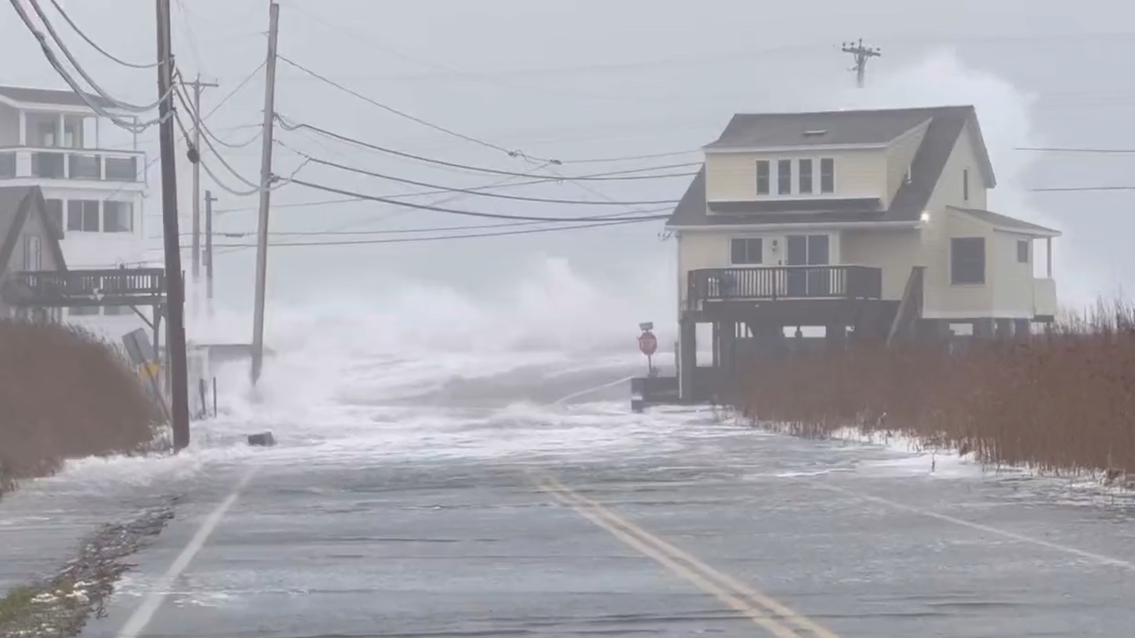
The worst flooding occurred on New York’s east shore of Lake Erie, in Buffalo. The powerful winds of the blizzard blew at 35-55 mph from the southwest along the length of Lake Erie much of Friday, causing waves on the lake to peak Friday over 20 feet. The same high winds also brought the lowest water levels on record toward the west end of the lake.
Beginning at 8:06 a.m. EST Friday, winds at the Buffalo Airport increased above 30 mph; they remained in the 33-46 mph range into the afternoon, with gusts as high as 70 mph. A gust of 79.4 mph was recorded at the Buffalo lakeshore on Friday morning.
The powerful winds brought visibility to zero in heavy snow for multiple hours on Friday afternoon, with temperatures at a frigid 10 degrees Fahrenheit.
Not only did these winds deliver heavy lake-effect snow, expected to accumulate to as much as three feet by Saturday afternoon, they also piled up Lake Erie’s waters along the eastern shore and caused moderate flooding in Buffalo. According to NOAA, the lake rose over eight feet on Friday, reaching the eighth-highest water level on record, 1.67 feet below the record of December 2, 1985.
Heavy snows also pummeled the coast of Ohio along Lake Erie; whiteout conditions led to a 50-vehicle pileup on the Ohio Turnpike on Friday afternoon that killed one person and closed the road in both directions.
Damaging coastal flooding and big waves slam the Mid-Atlantic and Northeast U.S.
Powerful winds gusting as high as 75 mph affected the offshore waters of the Mid-Atlantic and Northeast U.S. coast, bringing waves in excess of 22 feet off the coast of Maine, and a storm surge of up to three feet to the coast.
In Portland, Maine, water levels reached their fourth-highest levels on record Friday morning, falling just short of the record set during the Blizzard of 1978.
Compounding the weather woes in western Maine and New Hampshire were flash flooding and minor to moderate river flooding, from heavy rains of 1-3 inches that fell on a snowpack of up to a foot, causing melting of the snow.
During the Friday morning high tide cycle, damaging coastal flooding was observed along hundreds of miles of the Mid-Atlantic and northeastern U.S. shoreline, from Chesapeake Bay to western Maine. Storm surge barriers protecting Providence, Rhode Island, and New Bedford, Massachusetts, were both activated to prevent storm surge damage in those cities.
Many stations recorded high-water levels among their top-10 on record (using a list most recently updated in 2018). Some notable flood marks:
Portland, ME: moderate flooding, 4th highest on record (records to 1912);
Boston, MA: minor flooding, 9th highest on record (records to 1921);
Woods Hole, MA: minor flooding, 7th highest on record (records to 1932);
Newport, RI: minor flooding, 7th highest on record (records to 1930);
New London, CT: moderate flooding, 8th highest on record (records to 1938);
Bridgeport, CT: moderate flooding, 6th highest on record (records to 1964);
Montauk, NY: moderate flooding, 6th highest on record (records to 1947);
Sandy Hook, NJ: major flooding, 10th highest on record (records to 1932);
Boston, MA: moderate flooding, 8th highest on record (records to 1921);
Atlantic City, NJ: moderate flooding, not a top-10 water level;
Cape May, NJ: moderate flooding, not a top-10 water level;
Philadelphia, PA: moderate flooding, not a top-10 water level; and
Chesapeake Bay, MD (Bishops Head): major flooding, 10th highest on record (records to 2005).
Top-10 coastal flooding events are becoming more common because of sea-level rise from human-caused global warming. See the graphic embedded in the tweet below, which is based on storm-tide data (storm surges atop astronomical tides) from the Fort Point Channel near downtown at Boston Harbor. The highest crest shown occurred on Jan. 4, 2018.
A 21st-century Arctic outbreak falls short of 20th-century landmarks
Many stations in the central and northern Great Plains failed to rise above zero Fahrenheit on Thursday, with much colder overnight lows on Thursday and Friday. The spectacular temperature drops observed behind the Arctic front on Wednesday shifted toward the southeast on Thursday and Friday.
In Nashville, Tennessee, readings dropped from 45 degrees Fahrenheit at 8 p.m. Thursday to -1°F by 7 a.m. Friday. It was the city’s coldest temperature since Feb. 5, 1996.
Yet even -1°F in Nashville couldn’t hold a candle to the daily record of -8°F set on December 23, 1989. It’s just one example of how an Arctic outbreak this sharp and widespread was struggling to break records set in the colder climate of the 20th century (which included the intense pre-holiday cold blasts of 1983, 1989, and 1990).
Research continues into how much the amplified warming observed in the Arctic might be affecting the prevalence of the occasional jet-stream contortions that lead to extreme cold in the United States and elsewhere. Meanwhile, a broader trend appears to be toward milder winters across northern midlatitudes – which, of course, doesn’t rule out the continued possibility of destructive cold blasts, whatever their cause(s) might be.
The Twitter thread below includes observations and links from scientists on both sides of this ongoing debate. (See also the Yale Climate Connections post and the New York Times overview of the topic, both from this week.)
Beyond the Arctic outbreak, mild weather may prevail for awhile
Although a reinforcing blast of chilly air was expected to keep the eastern third of the country on the cold side well beyond Christmas, extended forecast models suggested a major warm-up would be under way by New Year’s weekend in most areas.
Northerly flow at the surface and upper levels that pushed Arctic air into the United States will be largely replaced in a few days by mild westerly flow off the Pacific Ocean.
Website visitors can comment on “Eye on the Storm” posts (see comments policy below). Sign up to receive notices of new postings here. Please direct media inquiries for Eye on the Storm’s Dr. Jeff Masters or Bob Henson here.
Source link