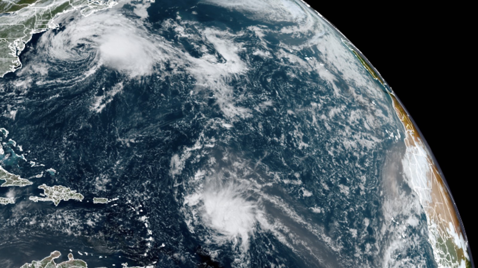
Tropical Storm Odette formed at 5 p.m. EDT Friday, September 17, in the waters a few hundred miles off the U.S. mid-Atlantic coast. At 11 a.m. EDT Saturday, Odette had top winds of 45 mph, was located 465 miles south-southwest of Halifax, Nova Scotia, and was headed northeast at 17 mph.
Satellite imagery showed Odette did not resemble a classic tropical storm. The surface center was exposed to view, and was broad, with multiple swirls. High wind shear of about 30 knots was keeping all of Odette’s heavy thunderstorms confined to the east side of the center. It is questionable whether Odette would have been named in the pre-satellite era.
Forecast for Odette
By Saturday night, Odette is expected to cross beyond the northern boundary of the Gulf Stream, where waters are cooler than 25 degrees Celsius (77°F). Wind shear will increase to 40 knots, accelerating Odette’s transition to an extratropical storm, likely by by Sunday afternoon. Despite its modest strength, Odette is pushing tropical-storm-force winds across an area 250 to 350 miles wide. Steering currents favor a track a few hundred miles offshore from the Canadian Maritime Provinces, and Odette could bring 40-mph winds and rains of one to two inches to southeastern Newfoundland on Sunday. In its 11 a.m. Saturday wind probability forecast, the National Hurricane Center gave Cape Race, Newfoundland, a 15% chance of experiencing sustained tropical storm-force winds of 39+ mph from Odette.
Steering currents are expected to collapse on Monday, resulting in Odette’s moving slowly and erratically a few hundred miles southeast of Newfoundland for multiple days. Later in the week, ex-Odette may exert a steering influence on disturbance 95L to its south, pulling that system northward before it can reach the U.S. East Coast.
Odette the fourth-earliest 15th storm since 1966
According to Phil Klotzbach of Colorado State University, only three other seasons since accurate satellite records began in 1966 have had as many as 15 named storms by September 17: 2020, 2011, and 2005. So far in 2021, the Atlantic has had 15 named storms, six hurricanes, and three major hurricanes. The 1991-2020 averages were 14.4 named storms, 7.2 hurricanes, and 3.2 major hurricanes, so it’s already been close to a full season’s worth of activity – and there’s over 40% of the season to go! It’s therefore likely we will run through the full list of 21 names for the second year in a row and only the third year in Atlantic history (2005 was the first).
The names remaining in 2021 are Peter, Rose, Sam, Teresa, Victor, and Wanda. The 22nd named storm of 2021 would be called Adria, as the season cycles through a new alphabetical list of 21 supplemental names (naming storms after Greek letters has been permanently discontinued).
Disturbance 95L, approaching Leeward Islands, likely to develop
A tropical wave designated 95L, located at 8 a.m. EDT Saturday morning about 650 miles east-southeast of the northern Leeward Islands, was headed west-northwest at 15 mph. Satellite imagery showed that 95L was much more organized than on Friday, with a better-defined circulation and more heavy thunderstorms, and was close to tropical depression status.
Conditions were favorable for development, with sea surface temperatures near 28.5 degrees Celsius (83°F) and light wind shear of 5-10 knots. However, the atmosphere was on the dry side, with a mid-level relative humidity of 50-55%. In total, though, these conditions likely will allow 95L to develop into a tropical depression by Saturday night. There is good, but not overwhelming, model support for 95L: The 12Z Saturday run of the SHIPS model gave 95L a 9% chance of rapidly intensifying by 35 mph in the 24 hours ending at 12Z Sunday.
The current west-northwest motion of 95L is expected to continue, resulting in the outer system bands’ bringing heavy rain showers to the northern Leeward Islands beginning Sunday evening. At that time, 95L is predicted to face a major obstacle to further intensification, the result of a large upper-level trough of low pressure. This trough is predicted to have high wind shear and dry air, and many model forecasts have 95L being destroyed by these hostile conditions by the middle of the week. In its 2 p.m. EDT Saturday Tropical Weather Outlook, NHC gave 95L 2-day and 5-day odds of development of 90%. The next name on the Atlantic list of storms is Peter. The first hurricane hunter mission into 95L is scheduled for Sunday morning.
Disturbance 97L could join the Atlantic’s parade of named storms
Another disturbance, dubbed 97L, is gradually organizing in the eastern tropical Atlantic south of the Cabo Verde Islands. There was a large field of strong convection around 97L on Saturday. Model ensembles are modestly supportive, and conditions are favorable, with SSTs around 28 degrees Celsius (82°F) and a moist mid-level atmosphere (relative humidity around 70%). Wind shear will be moderate to strong (10-20 knots) through the weekend but is forecast to decrease to 5-10 knots around Monday.
The window for any development of 97L likely will close by midweek, as the system heads northwest and encounters cooler SSTs, higher wind shear, and a steadily drier atmosphere.
In its 2 p.m. EDT Saturday discussion, NHC gave 97L a 50% chance of development through Monday, but no higher odds through Thursday. Those short-term odds rose from 40% at 8 a.m., and they may rise further if the development progress from early Saturday continues.
If 97L does develop, it is unlikely to attain hurricane strength or to make it very far west in the Atlantic, but it could still add to this hurricane season’s profusion of named storms. The next name on the Atlantic list after Peter is Rose.
Website visitors can comment on “Eye on the Storm” posts. Please read our Comments Policy prior to posting. Comments are generally open for 30 days from date posted. Sign up to receive email announcements of new postings here. Twitter: @DrJeffMasters and @bhensonweather
Source link


