Tropical Storm Nicole was at the verge of hurricane strength early Wednesday afternoon as it pounded the northwestern Bahamas with sustained winds near 70 mph with a storm surge predicted to be as high as six feet. Nicole is expected to intensify slightly into a category 1 hurricane before making landfall in Florida early Thursday morning. Because of Nicole’s large size, impacts from the storm will extend far to the north, and a damaging storm surge is likely along most of the southeast U.S. coast from central Florida to North Carolina. Damaging storm surge flooding already occurred during the Wednesday morning high tide cycle at many locations in Florida.
Nicole a large storm bringing widespread coastal flooding
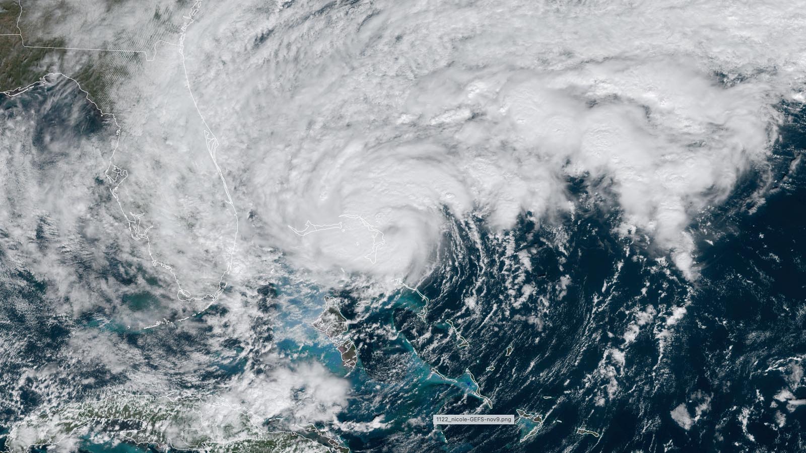
At 11:55 a.m. EST Wednesday, Nicole made landfall in the Bahamas on Great Abaco Island as a tropical storm with 70 mph winds and a central pressure of 985 mb. Nicole was headed west at 12 mph, and satellite images and Bahamas radar showed that the storm was building an eyewall, with a ring of heavy thunderstorms surrounding a calm eye, with heavy rains affecting the northwestern Bahamas and much of the Florida east coast. However, thunderstorm coverage was thin to the south of Nicole’s center, where dry air was present. Settlement Point on the west end of Grand Bahama Island reported sustained winds of 42 mph, gusting to 52 mph, at 2 a.m. EST Wednesday.
Satellite images, Bahamas radar, and data from the Hurricane Hunters showed that Nicole had built a complete eyewall with a diameter of about 30 miles, with a ring of heavy thunderstorms surrounding a calm eye. Heavy rains were affecting the northwestern Bahamas and much of the Florida east coast. However, thunderstorm coverage was thin to the south of Nicole’s center, where dry air was present. Nicole was a large storm, with tropical storm-force winds that extended out 460 miles to the northwest of the center, and 12-foot seas that extended out 690 miles to the northeast of the center.


Track forecast for Nicole
The track forecast for Nicole is pretty straightforward, with models in close agreement that the storm will move westward through the northwestern Bahamas Wednesday afternoon, then turn more to the west-northwest and make landfall in Florida between Delray Beach and Melbourne early Thursday morning. With Nicole perhaps barely reaching hurricane strength, there will not be a large area of hurricane-force winds. In its 11 a.m. EDT wind probability forecast, the National Hurricane Center gave Fort Pierce the highest odds of getting hurricane-force winds: 11%.
As Nicole crosses the Florida Peninsula, a trough of low pressure passing to the north will turn the storm to the north and then northeast, and it’s possible Nicole will briefly reemerge over the northeast Gulf as a weaker system late Thursday morning. Nicole will not be over water long enough to re-intensify before heading inland and tracking to the north-northeast along the U.S. East Coast.
Tropical storm watches are up for much of the Gulf Coast of Florida; 1-3 feet of storm surge is expected in Tampa Bay, with 2-5 feet to the north and northwest, from Tampa Bay to Indian Pass.


Intensity forecast for Nicole: only slight intensification likely
Although ocean temperatures are a very warm 28 degrees Celsius (82°F), dry air and high wind shear near 25 knots will continue to affect Nicole through landfall in Florida. These factors will combine to allow only slow development, and no top intensity models predicts its rapid intensification. The 12Z Wednesday runs of the SHIPS and DTOPS models gave a 12% chance that Nicole would intensify into a category 2 hurricane with 100 mph winds before landfall Thursday morning.
The Wednesday morning suite of intensity model forecasts predicted Nicole would make landfall in Florida with top sustained winds between 65 and 80 mph (i.e., as a strong tropical storm or category 1 hurricane). Given the large size of Nicole, and the unfavorable levels of wind shear and dry air, intensification into a category 2 hurricane is not expected.
Nicole is expected to bring a swath of 3-5 inches of rain along its path across Florida and northward into the southeast U.S.; the dry air to Nicole’s southwest likely will limit rainfall over extreme South Florida. The St. Johns River, which winds through northeastern Florida to the north of Orlando, was still at moderate flood stage this week because of Hurricane Ian’s rains at the end of September. Nicole’s rains are already causing the river to rise, and the river is predicted to hit major flood stage on Friday (Figure 4).
Nicole is expected to bring a wide swath of 2-4 inches of rain to the mid-Atlantic and Northeast. These rains likely will cause some isolated flooding, but will also help ease drought conditions present over portions of the region.


Significant coastal flooding expected
The full moon on Tuesday is bringing some of the highest tides of the year this week – the king tides. Minor to moderate coastal flooding was observed at multiple locations along the coast of Florida during the morning high tide on Wednesday, from the combined influences of the king tides, Nicole, and onshore flow driven by an unusually strong high-pressure system to the north of Nicole. A water level 2.12 feet above high tide (MHHW) was observed at Jacksonville, Florida (Mayport) during Wednesday morning’s high tide, the eighth-highest water level on record there since 1928. A probabilistic storm surge product from NOAA is estimating the station will have water levels on two consecutive high-tide cycles – Wednesday evening and Thursday morning – close to the modern record set in 2016 during Hurricane Matthew: 3.22 feet above MHHW. Matthew’s storm surge caused tens of millions of dollars in damage to northeastern Florida, washing out portions of State Highway A1A.
Major coastal flooding is predicted in Charleston, South Carolina, during the Thursday morning high tide, and a coastal flood watch for a storm surge of 1-3 feet is posted for much of coastal North Carolina.


Nicole generating waves nearly 30 feet high
Coastal damage will be especially high just to the north of where Nicole’s center crosses the coast; waves at the buoy 138 miles east of Cape Canaveral, FL, peaked at 28.5 feet on Wednesday morning (Figure 5). High waves on top of a large storm surge at high tide during the king tides are a recipe for significant coastal damage and beach erosion. Close to shore, high-surf advisories have been posted for breaking waves of up to six feet near Charleston, SC; 15 feet along the coast of Georgia; and 20 feet along the Florida coast from Daytona Beach to Jacksonville.
November landfalling storms are rare in U.S.
According to the NOAA hurricane database, 10 tropical storms and three hurricanes have made landfall in the continental U.S. in November or December since records began in 1851 – an average of one late-season landfall every 13 years. Only two of these storms made a direct strike on Florida’s east coast: the Yankee Hurricane of 1935, which hit just north of Miami Beach on November 4 as a category 2 hurricane with 100 mph winds, and Tropical Storm Seven of 1946, which made landfall in Boynton Beach with 45 mph winds on November 1. If it strikes Florida as a hurricane, Nicole would be the first hurricane landfall on the state’s Atlantic coast since Hurricane Katrina in 2005.
Bob Henson contributed to this post.
Website visitors can comment on “Eye on the Storm” posts (see comments policy below). Sign up to receive notices of new postings here.
Source link