
The first days of meteorological spring (March through May) will kick off with a serious severe-weather threat across multiple southern states on Thursday-Friday, March 2-3. In its Day 2 outlook issued Wednesday, NOAA/NWS Storm Prediction Center placed a broad band from eastern Texas to western Mississippi in a moderate risk for severe weather (its second-highest out of five risk categories) for Thursday.
A few strong tornadoes will be possible, along with widespread damaging wind and very large hail.
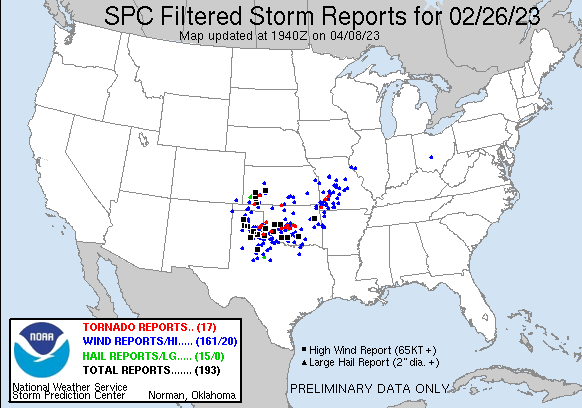
Compared with Sunday’s swarm of tornadoes and high winds centered in Oklahoma, the anticipated outbreak on Thursday is more in keeping with the usual location of late-winter and early spring severe weather across the lower Mississippi Valley and Deep South. Among the 12 tornadoes reported in Sunday’s outbreak was a 27-mile-long EF2 twister that passed only blocks from the National Weather Center, where the Storm Prediction Center is based.
Read: Climate change and tornadoes: Any connection?


Behind both of this week’s headline severe weather events is a persistent cold area of low pressure at upper levels that at times has extended far to the south across the western United States and the eastern Pacific. This upper-level trough and the associated cold air led to snowfall at strikingly low elevations across California late last week. The latest in a sequence of upper-level impulses within this trough brought yet another round of heavy snow to the California Sierra on Tuesday and Wednesday.
As the upper impulse heads eastward, it will bring a band of strong winds aloft over the Southern Plains by Thursday, which will help support the development of intense thunderstorms. Wind speeds six to eight miles above ground level are predicted to top 160 knots (184 miles per hour) over parts of Texas and Oklahoma by Thursday.


Meanwhile, sultry air with summerlike levels of moisture (dew point readings of 70 degrees Fahrenheit and higher) was already surging from the Gulf of Mexico well into the eastern United States. Temperatures above 80 degrees Fahrenheit made it across the Ohio River on Wednesday, leading to unheard-of warmth in the Corn Belt for so early in the season.
These ingredients should make for a potent mix of highly unstable air and strong, deep vertical wind shear by Thursday. What’s less clear is whether the ingredients will align to produce multiple sustained tornadic supercells — the storm type that leads to the most violent twisters — or whether it’ll be mainly an outbreak of brief but still-dangerous tornadoes embedded within fast-moving squall lines, as was the case in Oklahoma on Sunday night.
As of Wednesday, models were suggesting a layer of relatively weak midlevel winds around 10,000 feet could end up sandwiched between the surface and upper air, which would tend to work against long-lived tornadic storms (but wouldn’t rule them out).
The biggest threat for supercells will likely be on Thursday afternoon and evening near and south of a warm front that will extend east from an intensifying surface low, roughly from northeast Texas into Arkansas. Later in the evening, a powerful squall line will develop along a cold front in central and north Texas, rolling quickly across the Mississippi River overnight. Embedded tornadoes and destructive downburst winds could lead to widespread tree and power line damage across the area on Thursday night.
On Friday, storms are expected to redevelop along the cold front, with severe weather possible from eastern Kentucky and western Virginia southward to the Gulf Coast. The most unstable air will be pinched off from the Gulf by this point, but severe wind gusts and a few embedded tornadoes will be possible.
From late Friday into Saturday, heavy snow may develop across New York and much of New England on the north side of the surface low.
Increasing risk of flash floods in Arkansas
Well north of the warm front in Arkansas, the tornado threat should be lower but torrential rains could lead to localized flash flooding. On Wednesday, the NOAA/NWS Weather Prediction Center placed much of southeast Oklahoma and northern Arkansas in a moderate-risk area for excessive rain leading to flash flooding on Thursday.
Recent rains have left the soils quite wet, if not completely saturated, and the rugged terrain near the Ozarks is notorious for intense, localized flooding. Widespread rains of three to six inches across northern Arkansas could be accompanied by isolated amounts as high as nine inches, according to the Weather Prediction Center.
Jeff Masters contributed to this post.
Website visitors can comment on “Eye on the Storm” posts (see comments policy below). Sign up to receive notices of new postings here.
Source link