The shrunken Mississippi River, flowing at its lowest rate on record along much of a 270-mile stretch, will receive a minor short-term bump in water levels this week from Hurricane Roslyn’s rains. However, with another La Niña winter in the cards, the long-term outlook for the river is unfortunately very dry.
Expensive, widespread, and intense drought affecting the U.S.
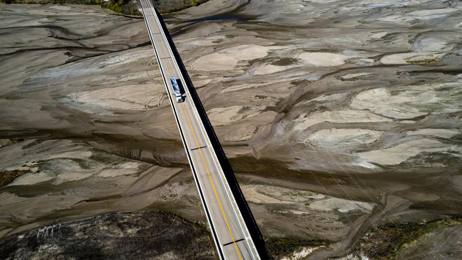
Intense, widespread drought conditions across much of the U.S. this year have cost more than $9 billion and are causing havoc to shipping on the mighty Mississippi River, which in three states has hit its lowest levels on record. The low water levels come at an extremely inopportune time – during the peak of the U.S. harvest season, when barges carrying grain provide the predominant transportation method to carry America’s bounty. Barges going downriver carry about 60% of U.S. grain exports to the world. Going upriver, Mississippi River barges transport petrochemicals, fertilizers, and raw materials essential for the functioning of U.S. industry and agriculture, making the Mississippi River the lifeblood of the American economy. If barge traffic on the Mississippi River is slowed for an extended period of time, the entire U.S. economy suffers, with impacts to the global economy and world food supplies.
As reported by Bloomberg on October 21, barge shipments of corn during the first week of were down 50% from the same time in 2021, and more than 2,000 barges were backed up. The low water levels have also allowed salt water to move upriver to threaten drinking water supplies in New Orleans, forcing the Army Corps to build an underwater dam to stop the upstream advance of the ocean water.
The ongoing U.S. dryness is even more impressive in its breadth than in its intensity. In the weekly U.S. Drought Monitor assessment released on October 13, a total of 81.8% of the contiguous United States was either abnormally dry (D0) or in some stage of drought (D1-D4). This was the largest weekly percentage tallied in the 1,100-plus weeks that have elapsed since the Drought Monitor began in January 2000.
The record was again broken just a week later, on October 20, when the fraction of the contiguous U.S. at D0-to-D4 levels climbed to 82.2%. At some point in 2022, all 50 states have experienced drought, and only three states – Alaska, West Virginia, and Delaware – were not experiencing at least D0 levels of dryness during the past week.
None of the specific drought categories (D1, D2, D4, or D4) are at record-high coverage levels right now, so it’s the sheer geographic spread of dry conditions that’s most noteworthy about the current 2022 drought. But the intensity is rising fast. The Drought Severity and Coverage Index, which incorporates both drought strength and drought scope, jumped from 150 in early January to 194 by late October. The highest value on record is 215, recorded on Aug. 14, 2012.
All-time Mississippi River low-water records set in 3 states
Five Mississippi River gauges with long-term periods of record along a 270-mile stretch of river in three states have set all-time low-water records this month. In Memphis, Tennessee, the river dipped to a new record-low water level of -10.81 feet on Saturday, October 22. The previous record was -10.70 feet, set on July 10, 1988, during the notorious summer of 1988. That year had America’s costliest drought since at least 1980, with $51 billion in damages. Data for the Memphis gauge goes back to 1933. (Typically, the zero level on a river gauge is set so that values go negative only during prolonged, intense dry spells.)
At least three other low-water records have been set along the Lower Mississippi north of Memphis:
Osceola, AR: -11.55 feet on Oct. 19 (previous record: -10.30 feet on July 11, 1988; data since at least 1927)
Caruthersville, MO: -1.73 feet on Oct. 18 (previous record: -0.82 feet on Aug. 30, 2012; data since at least 1931)
New Madrid, MO: -5.45 feet on Oct. 15 (previous record: -5.32 feet on Aug. 30, 2012; data since 1879)
A noteworthy record has also been set south of Memphis:
Greenville, MS: 5.51 feet on Oct. 23 (previous record: 6.70 feet on Jan. 4, 1964; data since at least 1890)
Hurricane Roslyn’s remnants will bring some short-term drought relief
One reason for the extent of U.S. dryness in recent months is the lack of landfalling tropical cyclones, apart from catastrophic Hurricane Ian, whose rains were limited mainly to Florida and other eastern seaboard states. Perhaps it’s not surprising that a hurricane – in this case, from the Pacific – will help ease the pain of drought across the south-central United States. Hurricane Roslyn, which rapidly intensified to category 4 strength, slammed into the Pacific coast of Mexico near Santa Cruz, north of Puerto Vallarta, on Sunday morning as a Cat 3 storm, with top sustained winds of 120 mph. Roslyn quickly dissipated on Sunday, but its remnants are being swept into the central U.S. by an approaching upper-level storm.


As moisture from Roslyn interacts with the upper storm and an associated cold front, showers and thunderstorms will douse the Southern and Central Plains from Texas to Illinois, especially on Monday and Tuesday. Widespread totals of 1 to 3 inches will help quench the soil and recharge rivers, and localized totals could reach 5 inches. Some severe weather, including a few tornadoes, will be possible, especially on Monday night.
Much of the heaviest rain from Roslyn’s moisture will fall across the Arkansas River basin, which flows into the Mississippi south of Memphis, so the benefits to river flow will be more limited further to the north.


An experimental forecast product that calculates flow through the lower Mississippi and Ohio rivers over the next 28 days, based on 16-day modeled rainfall (Figure 2), suggests that the low-flow crisis may have already hit bottom when averaged across the region. The product shows some renewed decline next week after a bump from Roslyn’s moisture, then followed by gradual improvement into early November.
The long-term forecast: dry
The longer-term outlook remains worrisome for U.S. drought into the winter of 2022-2023, as an unusual third-year La Niña event (the first such sequence since 1998-2001) is now in place and expected to continue for at least the next several months. NOAA’s latest Seasonal Drought Outlook, issued on October 20, calls for drought conditions to either persist or expand across most of the western and southern three-quarters of the contiguous U.S. from now through January.
Global trade increasingly vulnerable to extreme weather affecting key chokepoints
This is the second consecutive year that barge traffic on the Mississippi River has been seriously affected by extreme weather. In August 2021, category 4 Hurricane Ida passed directly over the Port of South Louisiana, the world’s largest bulk-cargo port, essentially halting barge traffic on the river for multiple weeks. Both this year’s drought and last year’s hurricane were more likely to have been so intense because of climate change. And as discussed here in March 2021, the shut-down of the Suez canal in 2021 by the grounding of the bulk cargo ship the Ever Given could have been a climate change-related event.
These events serve as a warning that climate change can be expected to cause an increase in extreme events that will impact critical global trade chokepoints. As explained in a 2017 report from Chatham House, much of the food required to feed 2.8 billion people passes through 14 critical shipping chokepoints (Figure 2): maritime corridors such as straits and canals, coastal infrastructure in major crop-exporting regions, and inland transport infrastructure in major crop-exporting regions. These chokepoints are at risk of closure brought about by three factors:
1) Extreme weather events or sea level rise;
2) Security and conflict hazards from war, political instability, piracy, organized crime and/or terrorism; and
3) Decisions by authorities to close a chokepoint or restrict the passage of food (for example, by imposing export controls).
Thirteen of the 14 critical chokepoints have had a closure or interruption in transit at least once between 2002-2017, with the Strait of Gibraltar the only exception. Many of these events had potential climate change connections: for example, the 2011 and 2012 heat waves in the U.S. that led to multiple derailments of trains where railroad tracks warped in excessive heat.


The report explained, “Climate change is increasing the threat of disruption by acting as a hazard multiplier across all three categories of chokepoint risk. It will increase the frequency and severity of extreme weather, leading to more regular closures of chokepoints and greater wear and tear on infrastructure. Rising sea levels will threaten the integrity of port operations and coastal storage infrastructure, and will increase their vulnerability to storm surges. Climate change is expected to aggravate drivers of conflict and instability. It will also lead to more frequent harvest failures, increasing the risk of governments imposing ad hoc export controls.”
Climate change will more frequently cause disruptions to critical global trade chokepoints in coming years. We need to take strong actions to prevent further damage, by reducing emissions of greenhouse gases; we must also prepare for future climate change-boosted extreme weather events by reducing vulnerabilities to chokepoint disruptions.
Website visitors can comment on “Eye on the Storm” posts (see comments policy below). Sign up to receive notices of new postings here.
Source link