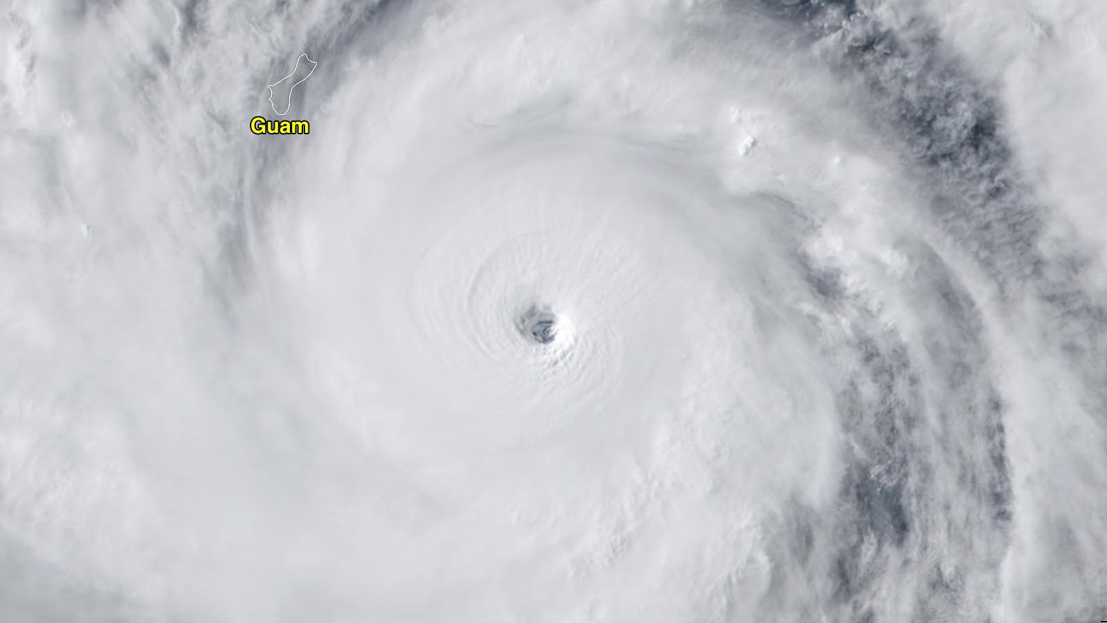
The U.S. territory of Guam in the Northern Mariana Islands is bracing for the arrival of Super Typhoon Mawar as it heads northwest at 7 mph toward an expected landfall Wednesday local time (Tuesday evening U.S. EDT). Guam radar showed the outer bands of Mawar were already affecting the islands, which were under a Flash Flood Watch. At 11:56 p.m. local time (9:56 a.m. EDT), Andersen Air Force Base, on the north end of Guam, recorded sustained winds of 25 mph, gusting to 40. At 12:54 a.m. local time (10:54 a.m. EDT), Guam International Airport recorded winds of 22 mph, gusting to 35 mph; the airport received 2.24 inches of rain in the 24 hours ending at 10 p.m. local time.
Mawar, meaning “rose” in Malaysian, put on an impressive feat of rapid intensification overnight, its winds increasing by 50 mph in the 18 hours ending at 6Z Tuesday (2 a.m. EDT), according to the Joint Typhoon Warning Center (JTWC). The Japan Meteorological Agency, the official agency responsible for typhoon warnings in the Northwest Pacific, estimated that Mawar’s central pressure fell by 35 mb, to 935 mb, in the 24 hours ending at 12Z Tuesday.
At 12Z Tuesday (8 a.m. EDT, 10 p.m. local time in Guam), Mawar had top sustained 1-minute average winds of 155 mph—just below the boundary for category 5 status—according to the Joint Typhoon Warning Center. The Japan Meteorological Agency rated Mawar as having 115 mph winds (10-minute average, which is normally substantially lower than the 1-minute average).

Forecast for Mawar
At 9:44 p.m. local time Tuesday, the National Weather Service in Guam was forecasting that Mawar would make landfall late morning or early afternoon on Wednesday local time, bringing sustained winds of 155 mph, gusting to 190 mph, with higher winds over elevated terrain. A storm surge of six to 10 feet was predicted, potentially reaching 20-25 feet in the northern eyewall. Torrential rains of 10-15 inches with locally higher amounts were predicted, and dangerous high surf of 20-30 feet was predicted to affect Guam through Wednesday.
Typhoon-strength winds extend out 40 miles from the center of Mawar. Guam is about 25 miles in diameter, so it is possible that the entire island will be subjected to typhoon-force winds. Given that the typhoon is moving relatively slowly, just 7 mph, the island will be subject to an extended battering by extreme winds, and damage will be very heavy – even though many of the island’s structures are well-designed to withstand extreme winds. The National Weather Service in Guam predicted that 50-70% of the island could be defoliated.
Mawar has favorable conditions for further intensification, with moderate wind shear of 15-20 knots and warm sea surface temperatures of 28-29 Celsius (82-84°F). Satellite loops show that Mawar is impressively well-organized, with a prominent eye surrounded by heavy thunderstorms with cold cloud tops. Warm waters extend to great depth along Mawar’s track, giving it plenty of heat energy to draw upon for intensification. The Joint Typhoon Warning Center is predicting that Mawar will intensify to a category 5 super typhoon with 160 mph winds by the time it hits Guam, at approximately 3Z Wednesday (1 p.m. Wednesday local time, or 11 p.m. Tuesday EDT).
Long-range forecast for Mawar
For the remainder of the week, Mawar will have favorable conditions for intensification, and it is expected to remain a very powerful category 4 or 5 typhoon, one of the strongest ever observed in the month of May. The Japan Meteorological Agency predicts that Mawar will peak with 10-minute sustained winds of 130 mph and a central pressure of 900 mb on Saturday. The 12Z Tuesday advisory from JTWC had Mawar at category 5 strength Friday through Saturday. The 6Z Tuesday run of the HWRF model had Mawar’s peak intensity after hitting Guam coming at 3 Z Friday, as a category 4 storm with 150 mph winds and a central pressure of 932 mb.
Mawar is expected to track generally west-northwest for the remainder of the week, and potentially turn to the north and recurve out to sea early next week. It is too soon, though, to dismiss a potential threat to the Philippines’ Luzon Island, which lay just outside JTWC’s 5-day cone of uncertainty. Taiwan, Japan’s Ryuku Islands, or mainland Japan could also be a target for Mawar next week. Once the typhoon moves north of about 22 degrees north latitude (roughly parallel with Taiwan), the storm will encounter water temperatures below 26 degrees Celsius (79°F), which would cause substantial weakening.
Guam typhoon history
According to the NOAA historical hurricane tracks website, only three major typhoons have made a direct landfall on Guam since 1945: Typhoon Karen on Nov. 11, 1962 (category 5, 170 mph winds); Typhoon Omar on Aug. 28, 1992 (category 3, 115 mph winds); and Typhoon Pamela on May 21, 1976 (category 4, 140 mph winds). According to EM-DAT, the international disasters database, the most destructive of these typhoons was Typhoon Karen of 1962, which killed six and did $2.4 billion in damage (2022 dollars). Guam’s deadliest typhoon was Pamela of 1976, which killed nine and did over $600 million in damage.
A number of destructive typhoons that hit the island in 1900 or earlier, which are not included in EM-DAT, are documented in the 2004 book, Typhoons in Micronesia. A history of tropical cyclones and their effects until 1914, and at the Guam National Weather Service website. The deadliest of these early typhoons appears to be a major typhoon on Nov. 13, 1900, that killed 34 people on Guam (Figure 2).

Mawar potentially the 9th category 4 or 5 storm to hit the U.S. since 2017
The U.S. and its territories have endured a brutal number of landfalls from high-end tropical cyclones since 2017, and Mawar could be the ninth category 4 or 5 storm to hit the U.S. in the past six years. This sort of battering is unprecedented in the historical record, and could be a harbinger of what climate change has in store. According to the NOAA fact sheet on Atlantic hurricanes and climate change (updated in 2023), Atlantic hurricanes reaching Category 4 or 5 intensity are projected to increase about 10% with 2 degrees Celsius of global warming (but with large uncertainty and with some studies projecting a decrease).

Storm chasers Jim Edds and James Reynolds are on Guam and will be documenting the impact of Mawar on the island via their Twitter feeds.
Bob Henson contributed to this post.
Website visitors can comment on “Eye on the Storm” posts (see comments policy below). Sign up to receive notices of new postings here.
Source link