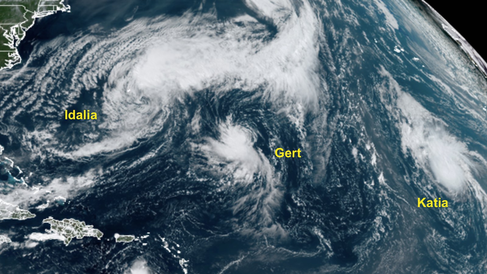
There was a bit more room in the crowded North Atlantic on Labor Day weekend after the demise on Friday of former category 4 Hurricane Franklin and short-lived Tropical Storm Jose. Now a post-tropical cyclone, Franklin continues to spin over the far North Atlantic east of Newfoundland, but it is no longer being tracked by the National Hurricane Center (NHC). Much smaller Jose was swallowed up by Franklin’s expansive circulation on Friday night.
The other two members of Friday’s closely packed quartet were still roaming the Northwest Atlantic on Saturday. There was also a new tropical storm far to the southeast, and yet another system of interest – by far the most concerning of the whole batch – just coming off Africa.
Post-Tropical Cyclone Idalia, located about 90 miles east-southeast of Bermuda at 11 a.m. EDT Saturday, was still packing top sustained winds of 60 mph, and brought sustained winds of 57 mph to an elevated observing site at the National Museum of Bermuda on Saturday morning. After losing its showers and thunderstorms (convection) on Friday, Idalia again boasted strong convection on Saturday. If reclassified by NHC, Idalia would most likely be declared a subtropical storm rather than a tropical storm, because it is now associated with a frontal zone and is thus an asymmetric warm-core cyclone. Whatever its designation, Idalia will continue sweeping northeast out to sea, posing no threat to any land areas.
Never-say-die Tropical Storm Gert continued its slow rebound on Saturday, with top sustained winds up to 50 mph as of 11 a.m. Saturday. Unusually warm waters of 29 to 30 degrees Celsius (84-86 degrees Fahrenheit) and a moist atmosphere continued to nurture Gert despite strong wind shear. As NHC forecaster Eric Blake put it, “Gert is one tough little cyclone.” Much as smaller Jose got absorbed by larger Franklin, compact Gert will be pulled northward toward sprawling Idalia over the next several days, perhaps maintaining tropical storm strength through Sunday or Monday.
Tropical Depression 12 in the eastern tropical Atlantic was upgraded to Tropical Storm Katia on Friday afternoon. Katia is the Atlantic’s twelfth tropical or subtropical storm of 2023, including an unnamed, belatedly recognized subtropical storm in January. In a typical year (1991-2020), the twelfth named storm does not occur until October 11.
As of 11 a.m. Saturday, Katia’s sustained winds were up to 50 mph. The storm had built a sharp, robust convective core despite moderate to strong wind shear, a mid-level atmosphere that was only moderately moist (relative humidity about 50 percent), and marginally warm sea surface temperatures of 26-27 degrees Celsius (79-81°F). Ultimately, Katia will be yet another low-impact system, as it heads northwest, ingests drier air, and moves toward remote Northeast Atlantic waters too cool to sustain a tropical cyclone.

Invest 95L likely to become the next Atlantic threat
A strong tropical wave that moved off the African coast on Friday night has embarked on a long and potentially noteworthy trip across the Main Development Region (MDR) of the tropical Atlantic Ocean. Designated Invest 95L on Saturday, this large and well-organized disturbance will roll west to west-northwest over the next few days over a very warm sea surface (29-30 degrees Celsius or 84-86°F). The Bermuda High that typically sprawls over the North Atlantic is predicted to strengthen, and 95L will be taking a less northwesterly track than many recent systems, giving it ample room to develop within the tropics. Upper-level winds are predicted to be light to moderate over the next several days, but trade winds will be on the weak side, resulting in a net easterly wind shear that could keep 95L’s development gradual at first. Models are still in some disagreement on 95L’s long-term future, which is not a surprise in these early days.
In its Tropical Weather Outlook issued at 2 p.m. EDT Saturday, NHC gave 95L development odds of 20 and 70 percent over the next 2 and 7 days, respectively. If it does develop and continues west-northwest, 95L could be approaching the Leeward Islands somewhere around next weekend, so there is plenty of time to keep an eye on it. The best hope for recurvature into the North Atlantic before that point would be if Katia or the remnants of other systems leave enough of a weakness in the Bermuda High for 95L to move toward. The next name on the Atlantic list is Lee.
Next typhoon threat for Asia: Haikui
Typhoon Haikui is predicted to become a category 3 or 4 equivalent before it slams into the east coast of Taiwan on Sunday. Although Typhoon Saola scraped the coast of Hong Kong on Friday at category 4 strength, causing widespread disruption and bringing sustained 2-minute winds of up to 115 mph nearby, the Associated Press reported that damage in and near Hong Kong (which is well prepared for typhoons) was relatively light.
Due to the Labor Day holiday weekend, we will be making limited updates and/or fresh posts until Tuesday.
Website visitors can comment on “Eye on the Storm” posts (see comments policy below). Sign up to receive notices of new postings here.
Source link


