Headlines
- Invest 98L is likely to develop in the next couple days as it tracks toward the northeast Caribbean.
- Interests between Puerto Rico and Guadeloupe should be preparing for at least a tropical storm impact.
- There is a chance that 98L could become a hurricane as well before it likely exits the northeast Caribbean and turns out to sea.
Invest 98L: A concern for the northeast Caribbean
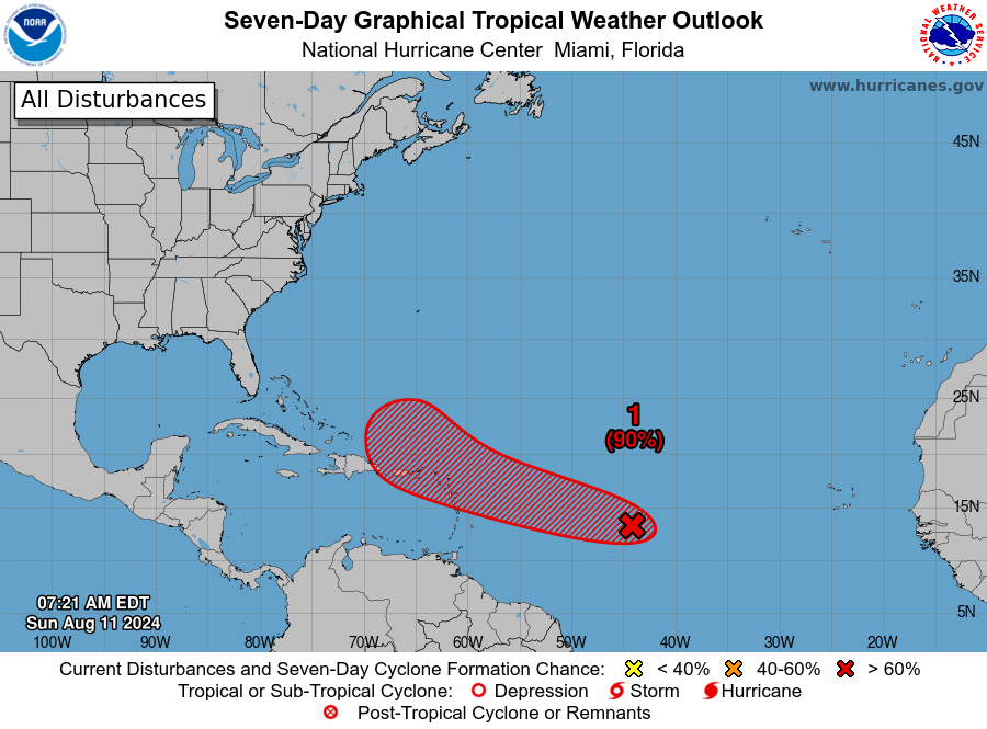
We have been greeted this morning by a 90 percent chance of development in the Atlantic from now-dubbed Invest 98L.
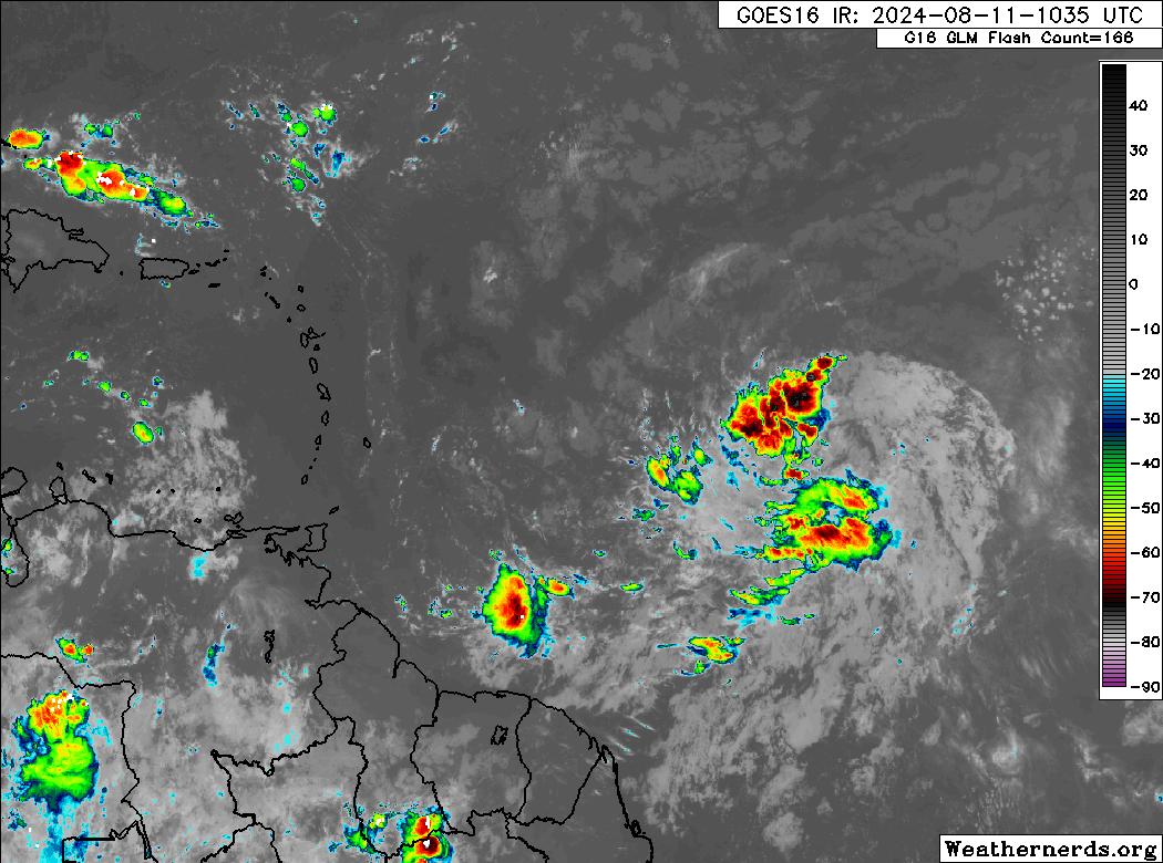
Looking at 98L this morning, it’s clearly slowly organizing east of the islands. That said, it’s a relatively large tropical wave, so this process is taking its time.
Relative to Friday, the expectations for 98L have not changed a whole heck of a lot: We still expect development as it comes toward the Caribbean, and interests in the Leeward Islands, Virgin Islands, and Puerto Rico should be monitoring the progress of 98L very closely.
Here’s what we know today:
- Invest 98L is probably going to turn northwest and north and head into the open Atlantic after passing through the northeast Carribean.
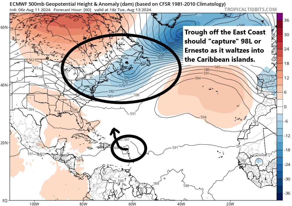
Is there a chance it misses the exit ramp? Sure, but that’s not likely at this time. The odds of development are such that 98L is probably going to start to slowly gain latitude as it approaches the Leeward and Virgin Islands, followed by more rapid development after it passes. This should be enough for it to find its way “into” the rather strong trough off the East Coast. The forecast map below is the European model forecast for Tuesday, with a strengthening 98L or Ernesto likely to brush across the northeast Caribbean islands and into the trough off the East Coast.
In a low likelihood situation, 98L would not develop much and could end up “trapped” in the northeast Caribbean, eventually forced back west or west-southwest by high pressure over the Deep South. That would change the equation entirely, but at this point there is little to no model support for that outcome.
In general, the hope is that once this passes the Caribbean islands, it will (mostly harmlessly) go out to sea
- Invest 98L is likely to begin wrapping itself up *as* it moves into the northeast Caribbean islands.
Where it really gets tricky is what 98L/Ernesto’s intensity will be as it moves into the northern Leewards, Virgin Islands, and off Puerto Rico. At this point, it seems reasonable to say that a developing tropical storm will be moving through those areas by later Tuesday and Wednesday. Could this quickly intensify into a hurricane? I would not rule it out.

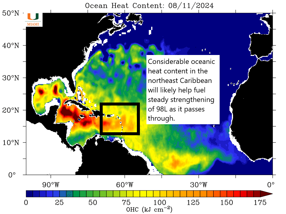
The system is going to track through some decent areas of oceanic heat content in the next couple days. This, coupled with low wind shear should provide ample fuel for strengthening as it comes through. The biggest limiting factor in development of this system may be some dry air and lingering Saharan dust in the area of the disturbance as it wraps up.
- The track into the northeast Caribbean will be tricky in terms of exactly what islands are hardest impacted.
Because of the track and turn of 98L as it comes west, the timing will be everything in determining which islands see the worst impacts from this system. Interests from Guadeloupe into the Virgin Islands should be watching this very closely and currently preparing for at least a stronger tropical storm impact. If 98L really wraps up quickly, then Puerto Rico and the USVI may not see much in the way of direct impacts. If the strengthening is more steady or slower, the odds of impacts there increase. We should hopefully get a little more clarity on this tomorrow, but I’d encourage that whole strip from Puerto Rico into about Guadeloupe to prepare accordingly.
Hopefully once past the islands that’s it for this one, but we’ll keep an eye on things.
More to come? Maybe not.
Behind 98L, there aren’t a whole lot of seedlings for development for now. The Euro says that in about 8 to 10 days we have another opportunity. It would appear that an extremely hostile background state in the atmosphere is going to track across the Atlantic over the next 10 to 14 days, with a lot of suppression and sinking air. This usually works against tropical development, so it’s possible we end up seeing a later August lull this year. I would caution that we’ve seen systems kind of materialize in the day 6 to 12 timeframe this season that didn’t necessarily appear like strong candidates initially. While it should be quiet for a bit, just keep that in mind.
I’ve already seen comments about this season possibly being a bust, which is understandable. But keep in mind that we still have about 90 percent of a typical hurricane season in front of us from an intensity standpoint, and between Beryl, Debby, and probably soon Ernesto, this will end up being one of the most intense starts to a hurricane season on record. Sometimes it’s quality, not quantity.
Source link