Should a megaflood similar to the Great Flood of 1861-62 hit California, there is good news and bad news regarding the safety of California’s approximately 1,500 dams.
The good news: California has one of the nation’s top dam safety programs, and a 2011 government study of a theoretical megaflood found that the state’s dams would hold — though it said “minor spillway damage and downstream erosion is plausible.”
The bad news? This optimistic assessment was proved wrong in February 2017 for a rainfall event that fell far short of the scenario’s megaflood. In addition, many California dams are in poor condition and in urgent need of repair.
California has a long history of cataclysmic floods, which have occurred about every 200 to 400 years, most recently in the 1860s. If a megaflood happened today, it could swamp the state’s Central Valley and cause more than $1 trillion in damage.
And catastrophic failures at the state’s dams could flood the homes of millions of California residents and overwhelm key infrastructure, such as the National Guard’s Joint Forces Training Center, the Naval Weapons Station Seal Beach, power plants, wastewater treatment plants, and Disneyland.
In this second part of a three-part series on California’s vulnerability to a megaflood, we’ll look at the sorry state of the U.S. dam infrastructure in general — and more specifically at the California dams at the highest risk of failure in a megaflood. Part One examined the results of a 2011 study introducing the “ARkStorm” scenario, which simulated what a repeat of California’s Great Flood of 1861-62 might do. Part Three will examine the increasing future threat of California megafloods in a warming climate.

A close call in 2017 at the nation’s tallest dam
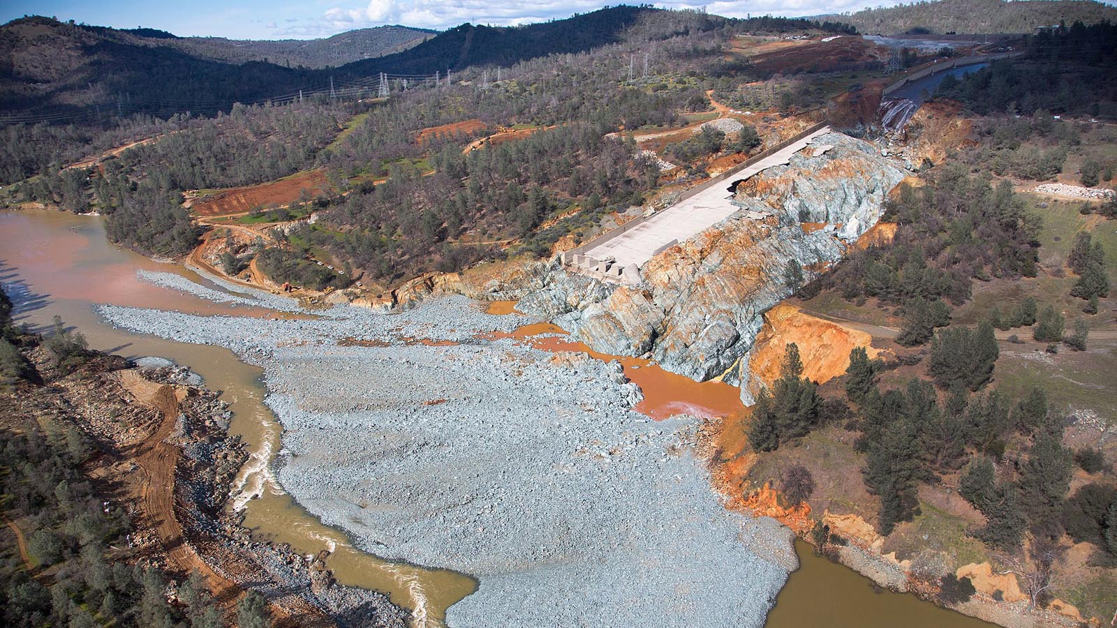
Over 180,000 residents of California living about 60 miles north of Sacramento fled their homes on short notice on Feb. 12, 2017, after the primary and emergency spillways of the state-owned Oroville Dam — the nation’s tallest dam, built in 1968 — suffered serious damage.
Heavy rains over the previous month had filled the dam’s reservoir, and release of turbulent floodwaters through the dam’s primary spillway tore enormous scour holes in the concrete structure. The damage forced dam operators to allow water to spill over the top of the emergency spillway. When the gushing waters of Lake Oroville began to rapidly erode the rock beneath the emergency spillway, threatening to breach the spillway’s retaining wall, the California Department of Water Resources issued this dire statement:
“Officials are anticipating a failure of the Auxiliary Spillway at Oroville Dam within the next 60 minutes.”
Residents of Oroville and neighboring areas were ordered to leave the area as soon as possible because of a potential flood of water up to 30 feet deep into the river below the dam. Fortunately, dam operators were able to juggle flows going over the two spillways, allowing the evacuation order to be lifted in the following days. However, major damage continued to occur to the spillways, adding up to a $1.1 billion repair bill.
The incident was blamed on human error, specifically inadequate inspection and maintenance. An independent investigation cited “a long-term systemic failure” by regulators and the dam industry to recognize and address warning signs.
The incident prompted the state, which runs the nation’s largest dam safety program, to increase the program’s budget from $13 million to $20 million and the number of full-time staff from 63 to 77. The state also enacted new emergency plan requirements and launched a review of 93 other dams with similar spillways.
Soberingly, the near-disaster at the Oroville Dam occurred after one-month rains that were less than the state experienced in 1998, 1995, and 1969 — and far lower than might be expected during a megaflood. The current state of the dam is not public because of security concerns.


The nation’s dams are aging, in poor shape, and not designed for the new climate
In California, as is the case for much of the U.S., dams are aging, in poor shape, and not designed for our new climate. The 2021 American Society of Civil Engineers Infrastructure Report Card assigned the U.S. a “D” grade (“Poor/At Risk”) for the dangerous state of its dams, the same grade the dams have received in the society’s assessments since the first one was issued in 1998. The average age of the approximately 91,000 dams in the U.S. is 57 years. Most of the existing large dams were built 50-100 years ago, with an average life expectancy of 50 years, though the life of well designed, constructed, maintained, and monitored dams can reach 100 years.
According to a 2021 report by the United Nations University, over 85% of all U.S. dams are operating beyond their life expectancy. And old dams are a hazard: Approximately 75% of all U.S. dam failures occurred for dams over 50 years old.
A key problem for old dams is that their reservoirs gradually fill up with sediment as they age, reducing their storage capacity and increasing dam overtopping and failure risk. Impeding sediment flows along a river can also make upstream regions more prone to flooding and erode downstream habitats. Reservoir capacity is reduced by about 0.1-0.5% per year, and this rate is expected to increase with climate change, because increased drought and wildfire in the surrounding watershed will produce increased debris during heavier downpours. One estimate found that at current reservoir sedimentation rates, the existing global reservoir storage capacity could fall by 25% by 2050. In addition, dams built for flood-control purposes for the climate of the 20th century may no longer be up to the task for the evolving climate of the 21st century, when heavier downpours can be expected to challenge infrastructure not designed for such extreme flows.
Read: Why is it raining so hard? Global warming is delivering heavier downpours
The 2021 American Society of Civil Engineers Infrastructure Report Card estimated that an investment of $28 billion is needed to adequately refurbish the nation’s federal dams. A 2022 report from the Association of State Dam Officials estimated that $76 billion is needed to refurbish non-federal dams. Most dams in the U.S. are privately owned, leaving owners responsible for the costs of upkeep. Those costs steadily increase as a dam ages, leading many owners to abandon them.
A government program to upgrade non-federal dams, the High Hazard Potential Dam Rehabilitation Program, was created in 2016. The goal of this program is to help fund the repair, removal, or rehabilitation of the nation’s non-federal, high-hazard-potential dams. In federal fiscal year 2022, this program was funded at $22 million, about 0.03% of the total funds needed and just 37% of its 2022 $60 million authorization. However, the $1 trillion infrastructure bill signed in 2021 by President Joe Biden will pump about $3 billion into dam-related projects, including hundreds of millions for state dam safety programs and repairs.
Fifteen high-hazard California dams in poor or unsatisfactory condition
Unfortunately, it is difficult to assess which dams in California may pose the greatest risk to lives and property in a megaflood. That’s because the conditions of many U.S. dams are kept secret from the public, listed as “not available” in the National Inventory of Dams, because of terrorism concerns, and no potential inundation maps are made available. However, the U.S. Army Corps of Engineers updated the database in 2021 to include hazard ratings, condition assessments, and inundation maps for more than one-quarter of the dams, according to a 2022 AP report.
One expert expressed concern about the lack of information.
“These structures impact people, and this is what we’re obviously most worried about. So it is important to share this information,” Del Shannon, a Colorado-based engineer who has assessed hundreds of dams and is president of the U.S. Society on Dams, told the AP.
A 2022 AP analysis identified 15 high-hazard California dams in “unsatisfactory condition,” the worst rating, or “poor condition,” the second-worst. By definition, a high-hazard dam is one whose failure could result in loss of life. Four of those dams were San Diego water supply dams that were downgraded from fair to poor condition after 2019 because of deterioration and concerns they could fail in an earthquake or extraordinary rainfall. As a result, the high-hazard dams at El Capitan, Hodges, and Morena reservoirs all are restricted to holding less than half their capacities.


Six high-priority dams to fix in California
The U.S. Army Corps of Engineers is responsible for the maintenance of 694 of the nation’s dams. They conduct regular dam safety inspections and assign a five-tier Dam Safety Action Classification (DSAC) action rating, depending upon the condition of the dams. The highest-priority dams to fix are rated DCAC-1, for an urgent and compelling threat, critically near failure, or extremely high incremental risk. The next highest action level, DSAC-2, is for a high urgency threat, a failure initiation that is foreseen, or very high incremental risk.
In California, there are two DSAC-1 dams — Whittier Narrows near Los Angeles, and the Isabella Lake Dam near Bakersfield — and four DSAC-2 dams, all in the Los Angeles area. Below are details of the flood risk for these six dams as made available to the public.
Whittier Narrows: California’s most dangerous dam?
One concerning example of the vulnerability of California’s infrastructure to an ARkStorm–style megaflood is the potential failure of the Whittier Narrows Dam on the San Gabriel River in the eastern Los Angeles metro area, built in 1957.
In 2019, a safety study by the Corps found that the dam’s foundation was at risk of erosion: “Although unlikely, a couple of dam failure scenarios triggered by rare, extremely high rainfall events, could lead to significant downstream flooding. These scenarios could occur when water exceeds the capacity of the reservoir and flows over the top of the dam, eroding it, or when water flows through the foundation beneath the dam, eroding it. If a dam failure were to occur, a wall of water would flood downstream areas, including many major roadways and highways that are considered evacuation routes. If the people downstream are unable to respond quickly and appropriately, they could be swept away by fast-moving water, which is forceful and deep enough to move vehicles within the flood area.”
Up to 1.2 million people could be flooded by a failure of the dam, with the highest water levels of 20 feet affecting Pico Rivera, a city of 63,000 that lies just downstream. According to the Corps, over 450,000 people downstream from the dam would be at risk from a worst-case breach, with a potential economic cost of over $6 billion. Among the sites that could be flooding under at least six feet of water are six power plants, two wastewater treatment plants, portions of California State University, Long Beach, as well as part of the Naval Weapons Station Seal Beach. This Navy base serves as the its primary West Coast ammunition storage and loading facility and has 128 ammunition storage depots.
The Corps performed emergency repair work on the dam’s gates and locks in 2018 and 2019 and is working on a $412 million project to upgrade to the dam. Some work has already begun, including the rerouting of utility lines. Major construction is scheduled to begin in 2024.


Isabella Lake Dam
Isabella Lake Dam, built in 1953, is located on the Kern River about 35 miles northeast of Bakersfield, California, and it impounds the state’s 16th-largest reservoir. If the dam failed, over 340,000 people who live along the Kern River below the dam would be at risk, primarily in Bakersfield (population 408,000, with a diverse population with many vulnerable lower-income residents) and Lake Isabella (population 3,600). In 2006, a seepage problem was found in the dam. Additionally, the Kern Canyon Fault under the dam, previously believed to be inactive, was found to be capable of producing an earthquake. These problems required officials to restrict the maximum reservoir elevation to 20 feet below normal “full” pool (the top of the spillway). Emergency management officials warned that if Isabella Dam were to fail when the reservoir was full, a large part of Bakersfield would be inundated within two to four hours.
In 2007, the Corps of Engineers ranked the Isabella Dam among the six highest-priority dams to fix in America. Since that time, a $635 million upgrade project has mostly been completed, and the Corps is going to allow the reservoir to begin filling up to full pool beginning in February 2023 to see if the seepage problem has been solved. If so, the dam may no longer be classified as a DSAC-1 dam.


The four DSAC-2 dams in California
Four dams in California – the Carbon Canyon Dam and Prado Dam just east of Los Angeles, the Mojave River Dam just north of Los Angeles, and the Lopez Dam on the northwest side of Los Angeles – are rated at the next-highest level of concern, DSAC-2. Even though a DSAC-2 classification is not the worst possible rating, it’s still an urgent risk because the chances of failure during normal operations or because of heavy rains is “too high to assure public safety.”
Prado Dam protecting Anaheim and Disneyland
The Prado Dam, built in 1941, is located on the Santa Ana River in Riverside County, California. If the dam failed, over 1.3 million people who live below the dam would be at risk and economic damages over $36 billion (and potentially as high as $61 billion) might result. Among the sites that could be flooding under at least six feet of water are Disneyland, the National Guard’s Joint Forces Training Center, portions of California State University (Long Beach campus), part of the Naval Weapons Station Seal Beach, six power plants, and three wastewater treatment plants. The Corps identified “concerns with the performance of the spillway and the potential for flood waters to flow between the dam embankment and spillway during a major flood event. This problem could potentially result in dam failure, flooding several cities between the dam and ocean.” The Prado Dam is currently undergoing an $880-million upgrade.


Carbon Canyon Dam
The Carbon Canyon Dam, built in 1960, is located on the Santa Ana River in Orange County, California. If the dam failed, over 580,000 people who live below the dam would be at risk, primarily in Brea, Yorba Linda, Fullerton, Placentia, and Anaheim, California; economic damages over $14 billion would be possible.
Mojave River Dam
The Mojave River Dam, built in 1971, is located in San Bernardino County, California, just north of Los Angeles. If the dam failed, over 10,000 people who live below the dam in Hesperia, Apple Valley, and Victorville would be at risk; economic damages over $1.2 billion would be possible. Funding to upgrade the dam was approved in December.
Lopez Dam
The Lopez Dam, built in 1954, is located near the city of San Fernando on the Pacoima Wash in the north central part of the San Fernando Valley. If the dam failed, about 1,500 people who live below the dam, primarily in San Fernando, would be at risk; economic damages over $27 million would be possible.
Bob Henson contributed to this post.
Website visitors can comment on “Eye on the Storm” posts (see below). Please read our Comments Policy prior to posting. (See all EOTS posts here. Sign up to receive notices of new postings here.)
Source link