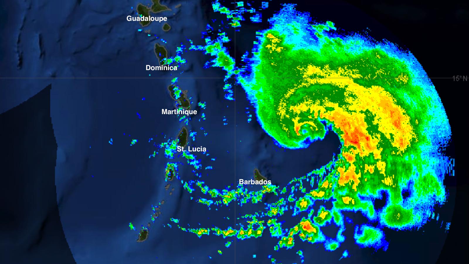
Hurricane Warnings are up for much of the Leeward Islands as an intensifying Hurricane Tammy gathers strength in the record-warm waters of the tropical Atlantic. Tammy is expected to be a category 1 hurricane as it passes near or over the Leeward Islands Friday night through Saturday night.
At 11 a.m. EDT Friday, Tammy was located about 240 miles southeast of Guadeloupe, headed west-northwest at 7 mph with top sustained winds of 75 mph and a central pressure of 992 mb, having just attained hurricane status at 10 a.m. EDT Friday, when the Hurricane Hunters found that Tammy had closed off an eye despite moderate wind shear of 10-15 knots. Satellite images early Friday afternoon showed that Tammy had a modest amount of heavy thunderstorms that were slowly growing more organized and more intense.

Forecast for Tammy
Conditions will be favorable for some modest intensification of Tammy over the next three days, with moderate wind shear of 10-20 knots, a reasonably moist atmosphere, and record-warm waters of 30 degrees Celsius (86°F), about 1-2 degree Celsius (1.8-3.6°F) above average. The system has good support for development from the models, which generally agree that a stronger storm is likely to track more to the northeast, potentially passing just east of the Leeward Islands, while a weaker storm is more likely to track farther west, passing over the Leeward Islands on Friday night through Saturday night. All of the 6Z Friday suite of regional hurricane models (HWRF, HAFS-A, HAFS-B, and HMON) showed Tammy passing through or just east of the islands as a strong tropical storm or category 1 hurricane. The island likely to receive the greatest impact from Tammy is Barbuda (population 93,000), which lies farthest to the northeast of any of the Leeward Islands.
Given the continued moderate westerly wind shear expected to affect Tammy during the next few days, most of the significant winds and rains of the storm will be to the east of the center, where heavy rains of 4-8 inches are predicted. Puerto Rico and the Virgin Islands are expected to be on the drier west side of Tammy, and receive lesser rain amounts. As of 11 a.m. EDT Friday, no tropical storm watches or warnings were in effect for Puerto Rico or the Virgin Islands.
An intensifying eastern U.S. upper low is expected to force Tammy to recurve northward into the open Atlantic after the hurricane passes through the Leeward Islands. Continued intensification is likely as Tammy pulls away from the islands, and the National Hurricane Center predicts that Tammy will peak as a category 1 hurricane with 90 mph winds on Monday and Tuesday.
Tammy is the second named storm to affect the Lesser Antilles Islands this month. Tropical Storm Philippe peaked with sustained winds of 50 mph as it passed through the Leeward Islands October 2-4. According to insurance broker Aon, Philippe flooded homes and vehicles in Antigua and knocked out power to 2,500 homes in nearby Guadeloupe. On Antigua, Philippe dumped 156 mm (6.14 inches) of rain in just six hours on October 3.
Norma weakens as it approaches Mexico’s Baja Peninsula
After peaking as a category 4 storm with 130 mph winds on Thursday, increased wind shear and drier air have taken their toll on Hurricane Norma as it gradually approaches the southernmost Baja Peninsula of Mexico. At 11 a.m. EDT Friday, Norma was positioned about 245 miles south of Cabo San Lucas, moving north-northwest at 8 mph. Norma had weakened to a category 2 hurricane with 110 mph winds and a central pressure of 960 mb. A Hurricane Warning was in effect for the southern tip of Baja California, and a Tropical Storm Watch was up for a portion of the west coast of mainland Mexico, north of Mazatlan.
Forecast for Norma
Over the next several days, Norma will be plagued by increasing wind shear (20-25 knots on Friday, increasing to 30-35 knots by Sunday) and increasingly dry air, as it traverses waters that will warm from 29 degrees Celsius (84°F) to 31 degrees Celsius (88°F). Despite the very warm sea surface temperatures, the higher wind shear and drier air will continue to cause significant weakening, and the National Hurricane Center predicts that Norma will weaken to category 1 strength by Saturday, well before any potential landfall.
The models have come into better agreement on Norma’s track, with the hurricane expected to pass close to or over the southern tip of the Baja Peninsula Saturday, followed by a landfall on Sunday night north of Mazatlan. Norma should be a tropical storm at that time, but will still be capable of dumping dangerous torrential rains of 5-10 inches.
North Indian Ocean heating up
In the north Indian Ocean, the Joint Typhoon Warning Center (JTWC) predicts that Tropical Cyclone 05A will intensify to a category 3 storm over the weekend, then weaken to category 1 strength by Tuesday as it approaches landfall near the Yemen/Oman border. The JTWC is also monitoring disturbance 92B in the Bay of Bengal, which has the potential to develop into a tropical depression early next week.
Website visitors can comment on “Eye on the Storm” posts (see comments policy below). Sign up to receive notices of new postings here.
Source link


