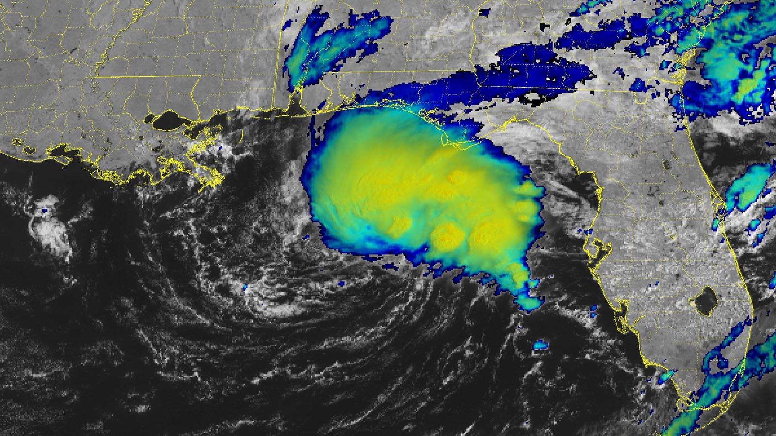
The Atlantic hurricane season officially began today, and right on cue, an area of disturbed weather in the Gulf of Mexico with the potential to develop into a tropical depression has formed. The disturbance, designated Invest 91L by the National Hurricane Center, or NHC, is meandering over the waters a few hundred miles south of the Florida Panhandle.
Conditions are marginal for development, with sea surface temperatures close to the threshold for tropical cyclone development: about 26.5 degrees Celsius (80°F). High wind shear of 30-40 knots and a fairly dry atmosphere (a midlevel relative humidity of 55%) are also marginal for development. Nevertheless, satellite loops on Thursday morning showed that 91L had developed a solid region of heavy thunderstorms on the east side of an elongated circulation center. Buoy 42039, located in the area of heavy thunderstorms, recorded sustained east-northeast winds of 29 mph, gusting to 51 mph, at 7:30 a.m. EDT Thursday. An Air Force hurricane hunter plane is on call to investigate 91L on Thursday afternoon, if necessary.
Steering currents favor a slow drift southward for 91L by this weekend, bringing the system over western Cuba or Mexico’s Yucatan Peninsula by Saturday night. Though sea surface temperatures will warm as 91L heads south, wind shear will ramp up to 40-50 knots by Saturday, which will likely put an end to any development. In their 8 a.m. EDT Thursday Tropical Weather Outlook, NHC gave 91L 2-day and 7-day odds of development of 50%. (This is the first system for which NHC is using its newly introduced 7-day outlook window, replacing the previous 5-day window.) The main threat from 91L will be heavy rains of 2-4 inches over portions of Florida, western Cuba, and the Yucatan Peninsula.
If 91L does become a tropical depression, it will be named Tropical Depression Two, since there was an unnamed subtropical storm that formed in mid-January. If 91L manages to become a named storm, it will be named Arlene, since the January subtropical storm did not get a name.

Colorado State University June 1 forecast: A near-average Atlantic hurricane season
With the storm-nurturing effects of a warm Atlantic likely to be counterbalanced by a robust El Niño, a near-average season is likely in 2023, the Colorado State University hurricane forecasting team says in its latest seasonal forecast, issued June 1.
Led by Phil Klotzbach, with co-authors Michael Bell and Alexander DesRosiers, the Colorado team is calling for 15 named storms, 7 hurricanes, 3 major hurricanes, and an Accumulated Cyclone Energy of 125. Accumulated Cyclone Energy is a measure of the total energy released by tropical cyclones and can be used to compare hurricane or typhoon seasons.
The long-term averages for the period 1991-2020 were 14.4 named storms, 7.2 hurricanes, 3.2 major hurricanes, and an Accumulated Cyclone Energy of 123. These numbers account for the short-lived unnamed subtropical storm that occurred in mid-January, as noted above.
The Colorado outlook predicts the odds of a major hurricane hitting the U.S. this year to be 43%. It gives a 21% chance for a major hurricane to hit the East Coast or Florida Peninsula and a 27% chance for the Gulf Coast. The Caribbean is forecast to have a 47% chance of having at least one major hurricane pass through. Notably, all four of these likelihoods are exactly the same as their long-term averages.
The Colorado forecast uses a statistical model honed from 40+ years of past Atlantic hurricane statistics, plus dynamical model output from four groups: ECMWF (European model), UKMET, Japan Meteorological Agency, and Centro Euro-Mediterraneo sui Cambiamenti Climatici.
Analog years
The Colorado team also selected five “analog” years with similar preseason atmospheric and oceanic conditions that the 2023 hurricane season may resemble. These years had neutral or La Niña conditions the previous winter, El Niño conditions during the peak of the Atlantic hurricane season (August–October), and above-average sea surface temperatures in the tropical Atlantic. They noted, however, that there has never been a year with a robust El Niño as well as near-record warm Atlantic sea surface temperatures. The analog years were:
1951 (12 named storms, eight hurricanes, and three major hurricanes);
1957 (eight named storms, three hurricanes, and three major hurricanes);
1969 (18 named storms, 12 hurricanes, and five major hurricanes);
2004 (15 named storms, nine hurricanes, and six major hurricanes); and
2006 (10 named storms, five hurricanes, and two major hurricanes).
The average activity for these years was 15 named storms, seven hurricanes, three major hurricanes, and an Accumulated Cyclone Energy of 125 – near the long-term average.

Hurricane season forecasts from 25 groups
At least 25 different groups have made 2023 Atlantic hurricane season forecasts, as cataloged by seasonalhurricanepredictions.org (Figure 2). For number of hurricanes, these forecasts range from below average (five, by Mexico’s SMN and Weatherworks) to hyperactive (15 from Skyfora and 11 from the UK Met Office), reflecting the uncertainty of how near record-warm waters and a potentially powerful El Niño event will shape the season. The consensus forecast by these groups calls for 15 named storms, seven hurricanes, three major hurricanes, and an Accumulated Cyclone Energy index of 122. Consensus forecasts are typically hard to consistently beat.
Forecasts from some of the groups that have been making seasonal hurricane forecasts the longest period of time are highlighted below.
TSR: Below-average season, with an Accumulated Cyclone Energy index 13% below average
The May 31 forecast for the 2023 Atlantic hurricane season made by British private forecasting firm Tropical Storm Risk, Inc., or TSR, called for a below-average Atlantic hurricane season, predicting 13 named storms, six hurricanes, two intense hurricanes, and an Accumulated Cyclone Energy of 90. The long-term averages for the past 72 years are 12.2 named storms, 6.4 hurricanes, 2.6 intense hurricanes, and an Accumulated Cyclone Energy of 105. TSR rated its skill level as moderate for these May forecasts: 8% – 11% higher than a “no-skill” forecast made using climatology.
TSR gave a 29% chance that the U.S. landfalling Accumulated Cyclone Energy index will be above average, a 38% chance it will be near average, and a 33% chance it will be below average. It projected three named storms will hit the U.S., one of them being a hurricane. The averages from 1950-2022 are 3.3 named storms and 1.5 hurricanes hitting the U.S. TSR rated its skill at making these May forecasts for U.S. landfalls at 11% – 16% higher than a “no-skill” forecast made using climatology. The next TSR forecast is to be issued on July 6.
UK Met Office: Hyperactive season, with 20 named storms
The most alarming Atlantic hurricane season forecast comes from the UK Met Office, whose May 26 forecast called for a hyperactive year with 20 named storms, 11 hurricanes, 5 major hurricanes, and an Accumulated Cyclone Energy of 222. Their forecast covers only the June-to-November period, so it does not include the unnamed subtropical storm that occurred in January. A hyperactive season is defined as having an Accumulated Cyclone Energy index of at least 214, which is 175% above average. Only seven seasons since 1851 have met this definition: 1933 (ACE of 259), 2005 (ACE of 245), 1893 (ACE of 231), 1926 (ACE of 230), 1995 (ACE of 227), 2004 (ACE of 227), and 2017 (ACE of 224). The Met Office’s eye-opening outlook is based on output from its on the Met Office’s ensemble-based modeling system GloSea, which is predicting less vertical wind shear over the tropical Atlantic than is typical for El Niño years as well as continued above-average sea surface temperatures throughout hurricane season.
The Weather Company: Slightly above-average season, with 16 named storms
The May 25 forecast from The Weather Company, produced by forecasting firm Atmospheric G2, called for a slightly above-average Atlantic hurricane season with 16 named storms, 8 hurricanes, and 3 major hurricanes. “The combination of an incipient El Niño and very warm north Atlantic sea-surface temperatures is unprecedented in the recent record,” the team wrote in their outlook.
University of Pennsylvania: Above-average season, with 16 named storms
The May forecast from Penn’s Michael Mann and Shannon Christiansen called for an above-average Atlantic hurricane season with 15.9 named storms (expected range: 12 to 20). Their prediction was made using statistics of how past hurricane seasons have behaved in response to sea surface temperatures, ENSO, the North Atlantic Oscillation, and other factors. Their statistical model assumed that the late-April +1.1 degree Celsius departure from average temperature in the Main Development Region would persist throughout hurricane season, that an El Niño event would occur, and that climatological mean conditions for the North Atlantic Oscillation would exist in the fall/winter of 2022.
A team led by Mann has been making Atlantic hurricane season forecasts since 2007, and these predictions have done well in 11 of 15 seasons.

NOAA predicts an above-average season in the central and eastern Pacific
NOAA’s May 2023 forecast calls for an above-average hurricane season in both the eastern Pacific (for storms affecting Mexico) and the central Pacific (for storms affecting Hawaii). The eastern Pacific outlook calls for a 70% probability of 14-20 named storms, with seven to 11 expected to become hurricanes, including four to eight major hurricanes. An Accumulated Cyclone Energy of 90% – 155% of the median was also predicted. Again here using the midpoint of these ranges, NOAA is calling for 17 named storms, nine hurricanes, and six major hurricanes, falling above the 1991-2020 averages of 15 named storms, eight hurricanes, and four major hurricanes.
NOAA’s central Pacific outlook calls for four to seven tropical cyclones (which include tropical depressions, tropical storms, and hurricanes). A near-average season there has four to five tropical cyclones. El Niño conditions typically lead to relatively active hurricane seasons in the eastern, central, and western Pacific as a result of warmer-than-average ocean temperatures and lower wind shear.
Tropical Storm Risk (TSR) predicts an active western Pacific typhoon season
TSR (tropicalstormrisk.com) issued its first seasonal typhoon forecast May 5 and called for an above-average typhoon season: 29 named storms, 19 typhoons, 13 major typhoons, and an accumulated cyclone energy index of 394 (31% above average). The 30-year averages (1991-2020) are 26 named storms, 16 typhoons, and 9 major typhoons. TSR gave a 60% chance the 2023 season would be in the top one-third of years for activity, a 31% chance of being in the middle third, and only a 9% chance of ranking in the lowest one-third.
To follow this year’s Atlantic hurricane season, we highly recommend subscribing to hurricane scientist Michael Lowry’s Substack feed, Eye on the Tropics (see Tweet above). Michael is a Yale Climate Connections contributor and also works for the South Florida TV station WPLG. He noted in his Substack post today: “although the European forecast model shows a blockbuster El Niño taking shape by September, the same modeling system predicts only modest wind shear in the Atlantic, yet another indication that El Niño may not give us its usual reprieve in 2023.”
Read: How to make an evacuation plan
Bob Henson contributed to this post.
Website visitors can comment on “Eye on the Storm” posts (see comments policy below). Sign up to receive notices of new postings here.
Source link