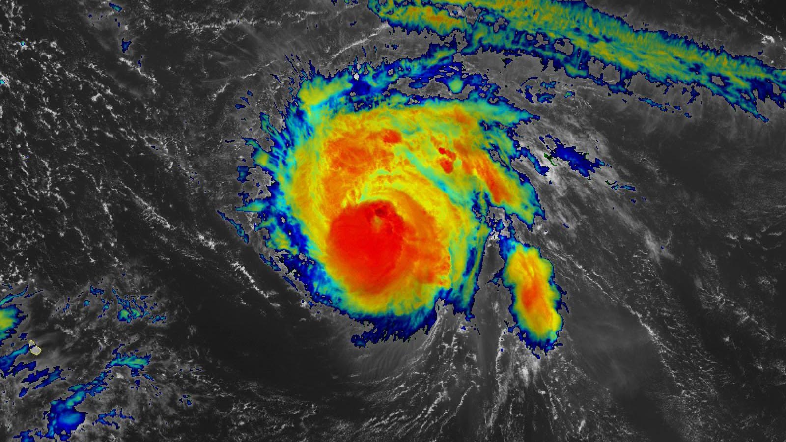
Compact but intense, Hurricane Sam continues to churn across the western tropical Atlantic on an unusually slow and prolonged track that may take it near Bermuda by week’s end. As of 11 a.m. EDT Monday, September 27, Sam was classified by the National Hurricane Center (NHC) as a Category 3 hurricane with top winds estimated at 125 mph.
Sam’s top winds were down from a Category 4 peak of 150 mph on Sunday, the result of an eyewall replacement cycle. These cycles, in which a small eye decays and a larger eye forms around it, typically result in a day or so of weakening that can lop a Saffir-Simpson category off a hurricane’s intensity, as was the case with Sam. In the process, the hurricane’s wind energy is spread over a larger area, so the result is a weaker but larger storm. Hurricanes can re-intensify after an eyewall replacement if conditions are favorable.


The eyewall replacement cycle was not yet complete at midday Monday, as Sam’s once-distinct eye has become obscured on infrared and visible satellite images. A hurricane-hunter mission in progress at midday Monday found a relatively high central pressure of 966 mb and winds that were only at marginal Category 3 strength.
Sam’s spectacular peak on Sunday was a climatological quirk. Hurricanes that strong are virtually unknown in the deep tropics between the Lesser Antilles and Africa so late in the year, as shown in the embedded tweet above. Sam benefited not only from unusually light wind shear and from its small size (which allows hurricanes to both strengthen and weaken more rapidly) but also from unusually warm sea surface temperatures for so late in the year across the Atlantic deep tropics.


Forecast for Hurricane Sam
Much like Hurricane Larry in early September, Sam appears destined to carve out a classic recurving path well out in the open Atlantic, racking up large amounts of accumulated cyclone energy, a measure of activity in a hurricane season. The main difference is size: Larry was a large hurricane, while Sam is a small one. The surface area covered by hurricane- and tropical-storm-strength winds by Sam is only a small fraction of what it was in Larry. However, calculations of accumulated cyclone energy do not take storm size into account, so Sam may end up contributing as much accumulated cyclone energy as Larry to the Atlantic’s 2021 total.
Sam could also end up ranking as a major hurricane for most of a seven-day period from Saturday, September 25, to Saturday, October 2, as reflected in the official National Hurricane Center forecast on Monday. Shear should remain light to moderate (under 15 knots) until Sam gets far enough north to encounter much stronger mid-latitude winds around Friday or Saturday. Sea surface temperatures beneath Sam’s path will remain quite warm (at least 28 degrees Celsius or 82°F) until at least Friday or Saturday. Potential intrusions of dry air, and the possibility of one or more additional eyewall replacement cycles, will be the main factors modulating Sam’s strength this week.
Steering currents for Sam over the next few days are well defined, and the GFS and European ensemble models are in close agreement. Sam is predicted to continue trundling northwest for the next several days, passing well to the northeast of the Leeward Islands. By late in the week, Sam is expected to angle north, most likely passing several hundred miles east of Bermuda around Saturday, although Bermuda was still on the west edge of the most recent five-day National Hurricane Center cone. By this point, swells and dangerous rip currents from Sam may be affecting the U.S. East Coast.
None of the members of the 0Z GFS and Euro ensembles hook Sam into the Northeast U.S., but it is possible that Sam may reach the Canadian Maritimes by early next week.


The one to watch: low pressure system in central tropical Atlantic expected to develop
An area of low pressure located in the eastern Atlantic near 8°N, 34°W, several hundred miles southwest of the Cabo Verde Islands, was headed west at about 5-10 mph on Monday afternoon. Satellite images showed that this low, which will likely be designated 91L, was embedded in the Intertropical Convergence Zone, the band of semi-permanent thunderstorms that circles the globe near the equator. The low had only a modest amount of heavy thunderstorms, and not much spin, on Monday afternoon.


The low’s position so close to the equator will slow development, as will the fact that it must separate itself from the Intertropical Convergence Zone, a process that is often slow to occur. However, all other factors the next three days appear favorable for development: light to moderate wind shear of 5-15 knots, warm ocean temperatures of at least 28 degrees Celsius (82°F), and a moist atmosphere. Wind shear may increase by late in the week, though, hampering development. The low has strong model support for development and is predicted to move west to west-northwest over the next week, arriving in the Lesser Antilles Islands around Monday, October 4.
In its 2 p.m. EDT Monday Tropical Weather Outlook, the NHC gave the low two-day and five-day odds of development of 50% and 80%, respectively. The next name on the Atlantic list of storms is Victor.
New tropical wave that emerged from coast of Africa expected to develop
A tropical wave that emerged from the coast of Africa on Monday morning has been designated 90L by THE NHC. Satellite images showed that 90L was growing more organized on Monday afternoon, with a moderate amount of spin and heavy thunderstorm activity. The wave was moving west at 10-15 mph and was at a very low latitude, near 7°N. This position so close to the equator will slow 90L’s development, but all other factors over the next five days appear favorable for development, as outlined for the nearby wave above.
90L has strong model support for development, but the models show a mostly west-northwest track for the wave, which would carry it into the central Atlantic where it would not threaten any land areas. In its 2 p.m. EDT Monday Tropical Weather Outlook, the NHC gave 90L two-day and five-day odds of development of 50% and 80%, respectively. The next name on the Atlantic list of storms after Victor is Wanda – the last name on the 2021 list of storms.
Peter may rise again
THE NHC is watching the remnants of Tropical Storm Peter, located several hundred miles east-southeast of Bermuda, which were moving northeast into the open central Atlantic at about 10 mph. Ex-Peter will have marginal conditions for development through Tuesday, but increased wind shear and cooler ocean temperatures on Wednesday should halt development. Ex-Peter is not a threat to any land areas. In its 2 p.m. EDT Saturday Tropical Weather Outlook, the NHC gave ex-Peter two-day and five-day odds of development of 60%.
Watching the waters south of Mexico’s Baja Peninsula
In the Eastern Pacific, the GFS model, which has done quite well at tropical cyclone genesis forecasts in 2021, has predicted in multiple recent runs that a tropical storm will form by Thursday and move northwards and potentially affect Mexico’s Baja Peninsula early next week. In its 2 p.m. EDT Monday Tropical Weather Outlook, the NHC gave this system two-day and five-day odds of development of 0% and 40%, respectively.


Japan keeping a wary eye on Typhoon Mindulle
After peaking as a category 5 typhoon with 165 mph winds on September 26, Typhoon Mindulle slowed to a crawl and upwelled a large amount of cool water over the weekend, cooling the ocean to a chilly 24 degrees Celsius (75°F) by Monday morning. These cool waters, in combination with an eyewall replacement cycle, dramatically weakened Mindulle to a category 2 storm with 105 mph winds at 8 a.m. EDT Monday, according to the Joint Typhoon Warning Center.
Mindulle was moving northwest at just 3 mph Monday morning but is expected to accelerate and turn to the north on Tuesday, allowing the typhoon to move back over warm waters of 29-30 degrees Celsius (84-86°F). These warm waters should allow some re-intensification to occur by mid-week.
By Thursday, Mindulle will be moving over colder waters and experience higher wind shear and likely weaken as it recurves to the northeast, parallel to the coast of Japan. Mindulle’s closest approach to Japan is predicted to occur near 6Z Thursday, when the center of the weakening category 2 typhoon is expected to pass 150-200 miles offshore from Tokyo. However, Tokyo was still in the Joint Typhoon Warning Center’s four-day cone of uncertainty in its 11 a.m. EDT Monday advisory, and Japan needs to keep a wary eye on the typhoon.
Website visitors can comment on “Eye on the Storm” posts. Please read our Comments Policy prior to posting. Comments are generally open for 30 days from date posted. Sign up to receive email announcements of new postings here. Twitter: @DrJeffMasters and @bhensonweather
Source link