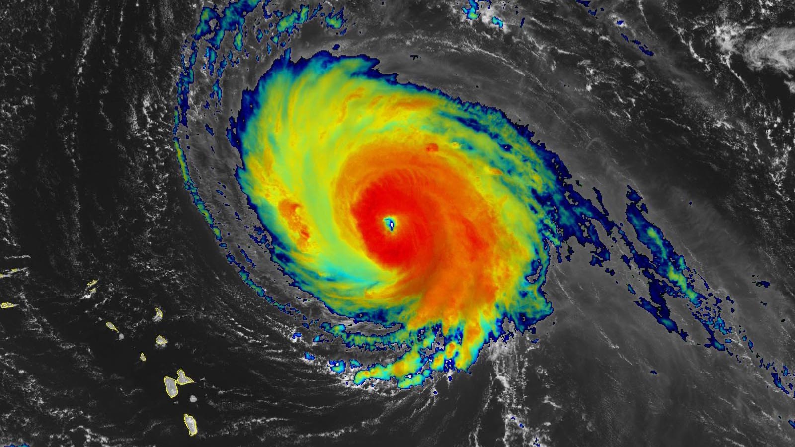
Hurricane Sam remained at category 4 strength on Wednesday as it churned across the central tropical Atlantic, well away from any land areas. Sam could complete an entire week at major hurricane strength (Cat 3 or stronger) by Saturday, when it will be passing east of Bermuda.
At 11 a.m. EDT Wednesday, Sam was a low-end category 4 hurricane with 130 mph winds and a central pressure of 949 mb, headed northwest at 9 mph. Sam appeared poised to undergo another eyewall replacement cycle, a process in which a hurricane’s eye degrades and is replaced by a larger concentric eye, over about a day’s time. An eyewall replacement cycle usually results in a larger hurricane, as the wind field gets spread out, but the peak winds decrease.
Sam’s long duration as a category 3 or stronger storm has made it a major wave machine, and it’s large swells were affecting portions of the Lesser Antilles and Greater Antilles on Wednesday. Large waves will propagate northward and eastward to affect much of the U.S. East Coast and the coasts of the Canadian Maritime Provinces by this weekend, bringing high surf and dangerous rip currents. The NOAA Hurricane Hunters measured significant wave heights of up to 25 feet on Monday, and the GFS model is predicting that waves at Sam’s core will increase to 35 feet by Saturday.


Little change in the prognosis for Sam
Sam likely will hold its own as a potent category 3 or 4 hurricane until at least Saturday as it moves steadily northwest, angling more northward by late in the week. Wind shear will remain light to moderate (5-10 knots), and Sam will have sea surface temperatures of around 28 degrees Celsius (82°F), with warm waters extending well below the surface. The atmosphere around Sam is on the dry side, with midlevel relative humidity only around 45-50%, which will limit the chances for it to undergo rapid intensification.
As Sam moves steadily closer to Bermuda later this week, it will be swept up by a strong upper-level trough of low pressure parked across the Canadian Maritimes and New England. The trough is expected to keep Sam just east of Bermuda and well away from the U.S. East Coast, but there is a modest chance Sam will angle slightly leftward and reach Newfoundland, as predicted by a few members of the GFS and European model ensembles (primarily from the GFS, which has outperformed the Euro in its predictions of Sam thus far).
Increased wind shear and cooler waters eventually will trigger Sam’s conversion into a powerful post-tropical storm over the far north Atlantic around Tuesday next week.


Tropical Depression 20 forms off coast of Africa
Tropical Depression 20 (TD 20) formed off the coast of Africa, about 500 miles south of the Cabo Verde Islands, at 11 a.m. EDT Wednesday. Satellite images showed TD 20 steadily growing more organized, with plenty of heavy thunderstorm activity and a low-level circulation center becoming more defined. TD 20 was moving west-northwest at 14 mph at an unusually low latitude, 8.3°N: The lowest latitude on record for an Atlantic tropical storm is 7.7°N, by an unnamed September 1902 storm.
TD 20’s position so close to the equator will slow its development, but all other factors over the next three days appear favorable for development. TD 20 was predicted by the National Hurricane Center to become Tropical Storm Victor by late Wednesday at latitude 8.8 north, and Hurricane Victor by late Thursday at latitude 10.3 north; both locations would be exceptionally close to the equator for an Atlantic system. The farthest south position on record for an Atlantic hurricane was 9.5°N, by Hurricane Ivan in 2004.
TD 20 is moving clockwise around a ridge of high pressure to its north, a steering flow that will carry the system to the northwest and then north late this week, taking it into the central Atlantic, far from any land areas. By Saturday, TD 20 is expected to move into an area of dry air and high wind shear of 20-40 knots, associated with an upper-level low. This encounter should dramatically weaken TD 20 over the weekend.
Disturbance 91L in eastern tropical Atlantic unlikely to develop
An area of low pressure located in the eastern Atlantic near 7°N, 33°W, several hundred miles southwest of the Cabo Verde Islands, was drifting west-northwest at roughly 5 mph on Wednesday. Satellite images showed that this low, designated 91L, had changed little since Monday, and it was poorly organized with few heavy thunderstorms. The low’s position so close to TD 20 was substantially interfering with development, a factor which alone makes it unlikely that 91L will develop. In its 8 a.m. EDT Wednesday Tropical Weather Outlook, the National Hurricane Center gave 91L two-day and five-day odds of development of 30%. The next name on the Atlantic list of storms after Victor is Wanda.
Peter not expected to rise again
The remains of Tropical Storm Peter, located several hundred miles south of Newfoundland, Canada, are experiencing high wind shear in excess of 30 knots, and are becoming inceasingly disorganized. Ex-Peter will move northeast into the open central Atlantic at roughly 10 mph, and it is no threat to any land areas. In its 8 a.m. EDT Wednesday Tropical Weather Outlook, the National Hurricane Center gave ex-Peter two-day and five-day odds of development of 10%.


Typhoon Mindulle predicted to brush Tokyo
After peaking as a category 5 super typhoon with 165 mph winds on September 26, Typhoon Mindulle was a weaker category 4 storm with 130 mph winds as of the 11 a.m. EDT Wednesday advisory from the Joint Typhoon Warning Center. Mindulle is expected to accelerate and recurve to the northeast this week, passing about 150 miles offshore from the Japanese main island of Honshu on Friday. At that time, the typhoon is expected to be a weakening category 2 storm with 105 mph winds. Tokyo will be on the weak (left) side of the storm, but will be within the region of tropical storm-force winds predicted for Mindulle.
Website visitors can comment on “Eye on the Storm” posts. Please read our Comments Policy prior to posting. Comments are generally open for 30 days from date posted. Sign up to receive email announcements of new postings here. Twitter: @DrJeffMasters and @bhensonweather
Source link