It’s been a weekend of spectacular satellite imagery of two hurricanes on opposite ends of the globe, both vaulting to impressive strength well away from land. In the remote Pacific, Mindulle rocketed to Category 5 status (see below), while in the tropical Atlantic, Hurricane Sam rapidly intensified to Category 4 strength on Saturday afternoon, September 25.
As of 11 a.m. EDT Sunday, Sam’s top sustained winds were at their peak thus far of 145 mph, making it the second strongest Atlantic hurricane of the year, after Ida (top sustained winds 150 mph).
Sam’s burst of strengthening was aided by its small size, an aspect that allows hurricanes to both intensify and weaken rapidly. As of Sunday morning, Sam’s hurricane-force winds extended out only 20 to 30 miles from its center, and tropical-storm-force winds were confined to a radius of 90 miles.
Hurricane #Sam has put on a show the last 24 hours intensifying from a Category 1 to Category 4 Hurricane.
Thought it would be nice to share what that 24-h evolution looks like on 1-min res GOES-16 water vapor.
Wait until the end as the
fully clears out. Incredible. pic.twitter.com/D4yGoOeCjC — Philippe Papin (@pppapin) September 25, 2021


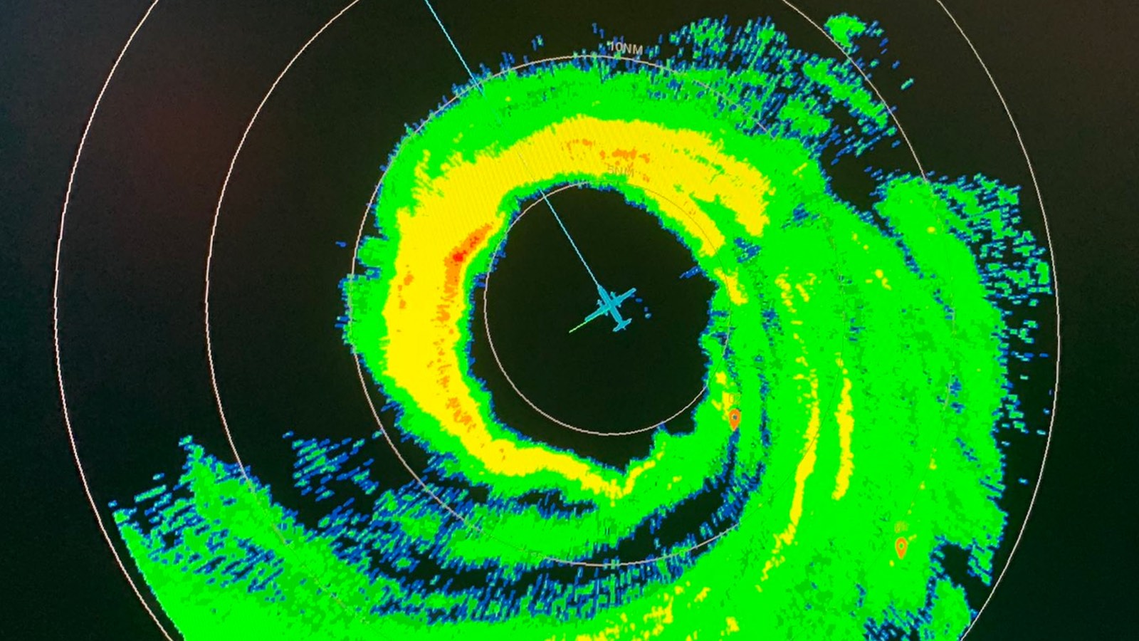
Sam was an exceptionally healthy hurricane on Sunday, with strong upper-level outflow and lightning detected by satellite in its eyewall.
It will be Sunday evening before we have the next in-person measurements of Sam’s strength from reconnaissance aircraft. Data collected by dropsonde and SFMR from a recon flight on Saturday evening suggested that Sam might have briefly approached or reached Category 5 strength. However, satellite images did not quite support a Cat 5, and the National Hurricane Center concluded that the recon observations were more consistent with brief eyewall vortices, perhaps even the size of tornadoes, rather than reflecting the storm as a whole.
On Sunday morning, satellite imagery designed for assessment on the Dvorak intensity scale supported the NHC diagnosis of Sam as a powerful, steady-state Category 4 storm.


Forecast for Sam
Sam has all the ingredients needed to remain a powerful hurricane for days to come. Relatively dry air in the large-scale environment (mid-level relative humidity around 50-55 percent) is the only major hindrance, but the small core seems to have walled off enough moisture to keep itself largely intact. Sam will continue to pass over warm water over the next several days, with sea surface temperatures of 28-29 degrees Celsius (82-84°F), and wind shear is projected to remain light (5-10 knots) through at least Wednesday.
We can expect one or more eyewall replacement cycles over the next several days: These may bring down Sam’s top winds somewhat but would also serve to enlarge the hurricane’s overall wind field. Sam is a slow-moving hurricane, which may allow it to upwell cooler water, although unlikely to be a major issue until later in the week as it reaches higher latitudes. The NHC forecast calls for Sam to remain a Category 4 storm until Wednesday and a Cat 3 storm through at least Friday.
Sam’s track will be fairly straightforward this week – toward the northwest, angling slightly northward by late week as Sam begins to feel the effects of a powerful upper-level trough moving off the northeast U.S. coast. This trough may steer Sam toward Bermuda next weekend, and it likely will also keep Sam from moving far enough west to affect the U.S. East Coast other than with some potentially rough surf and swells. All of the members of the 0Z Sunday European and GFS model ensembles show Sam carrying out a recurving path well east of the U.S., with only a few members angling the hurricane slightly west into the Canadian Maritimes. The consistency across models and over the last several days lends growing support to the idea that Sam will not be a major U.S. threat, although it is still too soon to make that call with certainty given that Sam is still more than a week from any potential North American approach.


Elsewhere in the Atlantic
The NHC was tracking three other systems of interest in its 2 p.m. Sunday tropical weather outlook:
—A strong, low-latitude wave in western Africa will move into the tropical Pacific on Monday. As with Sam a few days ago, this wave will encounter favorable conditions as it moves. There is strong model support for this wave to become a tropical cyclone as soon as midweek. Much like Sam, model ensembles suggest this new wave will move west-northwest and eventually northwest, toward a likely recurvature in the central Atlantic. The NHC gave this system a 10% chance of development through Tuesday but a 60 percent chance by Friday.
—Another system may develop just west of the African wave from an area of disturbed weather now stretching across the central and eastern tropical Atlantic. Though the formation odds from NHC were slightly lower for this potential system – near zero through Tuesday, and 50 percent between Tuesday and Friday – the predicted steering currents will give it a better chance of moving into the Caribbean if it does develop.
—The remnants of never-impressive Tropical Storm Peter continue to fester well southeast of Bermuda within a large, elongated zone of convection. NHC gave 30% odds that this system could take on tropical or subtropical characteristics over the next five days, most likely by Tuesday if it does happen.


Super Typhoon Mindulle becomes Earth’s 5th category 5 storm of 2021
Not to be outdone by the Atlantic, the Northwest Pacific answered back with an even more impressive feat of rapid intensification on Saturday night, with Super Typhoon Mindulle exploding into a category 5 storm with 160 mph winds. According to the Joint Typhoon Warning Center (JTWC), Mindulle’s winds increased by 80 mph in the 24 hours ending at 0Z September 26 – a rate of intensification rarely seen.
At 2 a.m. EDT Sunday, Mindulle had further intensified to 165 mph winds; the Japan Meteorological Agency put Mindulle’s central pressure at 920 mb. While Mindulle did have favorable conditions for intensification, with deep, warm waters and low wind shear, its intensification was somewhat surprising, given that it occurred while the storm was moving very slowly, at less than 5 mph. Slow-moving storms typically upwell a large amount of cool water that acts as a brake on intensification. In its favor, Mindulle had been traversing a region with very high oceanic heat content, 100-125 kilojoules per square centimeter.


Mindulle is turning to the north, and it will recurve to the northeast this week, passing very close to Japan on Thursday. Tokyo was well within JTWC’s 5-day cone of uncertainty in its 11 a.m. EDT Sunday advisory, and Mindulle is predicted to be a category 2 storm at the time of its closest approach to Tokyo.
As of 8 a.m. EDT Sunday, Mindulle had weakened slightly to Category 4 status, according to JTWC. It remained a super typhoon, with top sustained winds of 150 mph.


A typical year’s worth of Category 5 storms already in 2021
Earth has had five category 5 storms so far in 2021:
Super Typhoon Mindulle in the Northwest Pacific
(165 mph winds, 920 mb central pressure, September 26);
Super Typhoon Chanthu in the Northwest Pacific near the Philippines
(180 mph winds, 905 mb central pressure, September 10);
Super Typhoon Surigae in the Northwest Pacific near the Philippines
(190 mph winds, 895 mb central pressure, April 17);
Tropical Cyclone Faraji in the southwest Indian Ocean
(160 mph winds, 925 mb central pressure, February 8); and
Tropical Cyclone Niran in the South Pacific Ocean
(160 mph winds, 931 mb central pressure, March 5).
Website visitors can comment on “Eye on the Storm” posts. Please read our Comments Policy prior to posting. Comments are generally open for 30 days from date posted. Sign up to receive email announcements of new postings here. Twitter: @DrJeffMasters and @bhensonweather
Source link