Hurricane Lee has maintained its intensity while expanding greatly in size as it continues to churn toward an expected landfall in Atlantic Canada or New England this weekend. Lee’s large size and high winds will create huge waves that will batter most of the Atlantic coast from the Caribbean to Atlantic Canada this week.
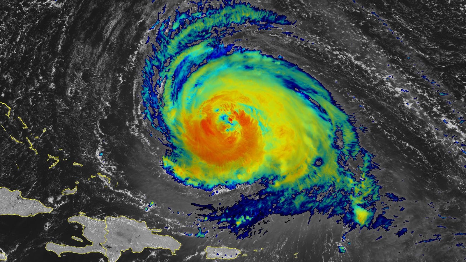
As of 11 a.m. EDT Tuesday, Lee was a Category 3 hurricane with top sustained winds of 115 mph and a central pressure of 951 mb, centered about 555 miles south of Bermuda, headed west-northwest at 6 mph. Lee underwent a third eyewall replacement cycle (ERC) overnight, giving the hurricane a big eye with about a 50-mile diameter. The huge wind field of Lee now has hurricane-force winds that extend up to 90 miles from the center, and tropical storm-force winds that extend out up to 205 miles.
Track forecast for Lee
The large-scale outlook for Lee’s movement has changed little. On Wednesday and Thursday, Lee will be rounding the southwest side of a large ridge of high pressure in the North Atlantic and will feel the influence of an upper trough over eastern North America. Forecast models remain in firm agreement that these factors will induce a fairly sharp northward turn and a gradual northward acceleration through the rest of the week.

After Lee passes to the west of Bermuda (which is under a Tropical Storm Watch, with a 49% chance of experiencing tropical storm-force winds), the models diverge somewhat on Lee’s eventual landfall location. The 0Z Tuesday run of the European model favored a slower pace for Lee, bringing it very close to Cape Cod, with an eventual landfall in Maine on Sunday morning. The GFS model had a faster solution, with Lee making landfall on Saturday afternoon in Nova Scotia. The UKMET model was similar to the GFS but not quite as fast, with a Nova Scotia landfall late Saturday or early Sunday.
As it moves north, Lee will also enlarge, its winds weakening but spreading over a much larger area, and regardless of the exact landfall location, the storm’s large size means that several hundred miles of the coast will experience tropical storm conditions (Figure 2). NHC predicts that on Friday morning, Lee will have tropical storm-force winds that extend out 275 miles to the northeast of the center, and 265 miles to the northwest. Such winds can be strong enough to bring down trees limbs and power lines.

Intensity forecast for Lee
Lee will soon be moving over cooler waters churned up by the recent passage of Hurricanes Franklin and Idalia, and the slow motion of the hurricane will make it more prone to weakening from the cooler waters that its large wind field will churn up. In addition, wind shear will increase by late week, so Lee is expected to weaken to a Category 1 hurricane by Friday, making landfall this weekend at tropical storm strength. Near the time of landfall, Lee will be undergoing a transition to a post-tropical storm.
Lee brings a heavy rain and flood threat
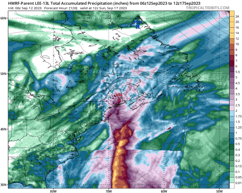
Lee’s large size means that the storm will be bringing heavy rains to a large portion of Atlantic Canada and northeastern New England. The 6Z Tuesday run of the HWRF model (Figure 3) predicted widespread rains of 2-5 inches falling over eastern Massachusetts, most of Maine, and much of Nova Scotia and New Brunswick.
Any heavy rains will be very unwelcome in New England, which suffered through one of its wettest summers on record. Case in point: Leominster, Massachusetts, located about 40 miles northwest of Boston, suffered what the governor of Massachusetts called “catastrophic flooding” on Tuesday morning after 6-9 inches of rain fell on Monday. As reported by Michael Lowry in his Substack post today: “One of the primary concerns with any direct brush with New England from Lee are the very saturated grounds in the area. Large swaths of Connecticut to Maine have recorded some of their wettest summers on record. This year the Boston area has observed its wettest 3-month period to-date in its 152-year period of record” (Figure 4).
In Atlantic Canada, a number of cities have also had their wettest summers on record, including Yarmouth, Greenwood, Kentville and Sydney in Nova Scotia; Saint John and Fredericton in New Brunswick; and Charlottetown in Prince Edward Island.
Now a hurricane, Margot is spinning safely in the remote North Atlantic
Former Tropical Storm Margot became the fifth hurricane of the 2023 Atlantic season at 5 p.m. EDT Monday. Margot’s upgrade to hurricane strength is another sign of an Atlantic season that has thus far been on the busy side of a mixed bag of outlooks issued earlier in the year. Based on 1991-2020 data, the fifth hurricane in the Atlantic typically arrives on October 15.
As of 11 a.m. EDT Tuesday, Margot was centered in the remote subtropical central Atlantic, almost 900 miles southwest of the Azores, moving north at 12 mph. Margot’s circulation included a compact core of strong showers and thunderstorms, surrounded by a much broader field of gale-force winds and weaker rainbands. Margot’s top sustained winds are 85 mph, and the hurricane will likely hover at or near this peak for the next couple of days, perhaps approaching Category 2 strength. Wind shear, currently light to moderate (5-15 knots) will increase by Thursday; by that point, the sea surface temperature below Margot’s path will be dropping to around 26-27 degrees Celsius (79-81 degrees Fahrenheit). Together, these factors are predicted to gradually weaken Margot below hurricane strength by the weekend as it remains far from land.
New African disturbance 98L has the potential to develop
A tropical wave located a few hundred miles east of the coast of Africa (Invest 98L) early Tuesday afternoon had a moderate amount of spin but was generating only a sparse amount of disorganized heavy thunderstorms, as seen on satellite images. The wave is expected to move west to west-northwest at 15 mph and develop over the central tropical Atlantic late this week, according to the GFS and European models and many of their ensemble members.
Long-range forecasts currently show that this wave is likely to take a more northwesterly track later in the week, giving it a good chance of being a “fish” storm which would not be a threat to any land areas, save Bermuda. In their 8 a.m. EDT Tuesday Tropical Weather Outlook, NHC gave 98L 2-day and 7-day odds of development of 20% and 70%, respectively. The next name on the Atlantic list of storms is Nigel.
Website visitors can comment on “Eye on the Storm” posts (see comments policy below). Sign up to receive notices of new postings here.