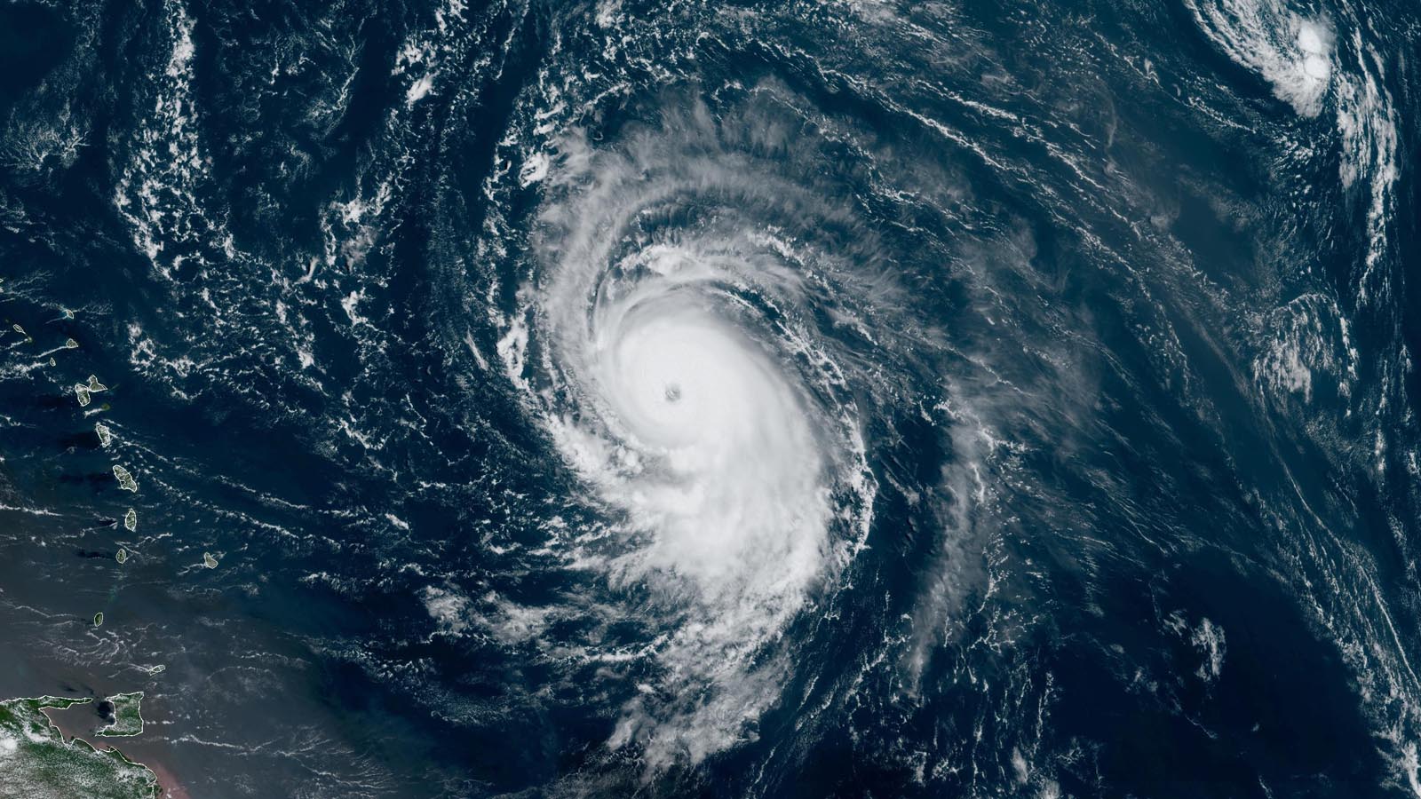
Hurricane Lee is rapidly intensifying over the record-warm waters of the tropical Atlantic and is predicted to become an extremely dangerous Category 5 hurricane by Friday night.
At 11 a.m. EDT Thursday, Lee was located about 870 miles east of the northern Leeward Islands, moving west-northwest at 15 mph with top sustained winds of 105 mph and a central pressure of 983 mb. Satellite images early Thursday afternoon showed a prominent eye had developed, and heavy thunderstorm activity was steadily growing more intense. Given the steadily improving appearance of Lee, it is likely to be a Category 4 hurricane by Thursday night, as predicted by the National Hurricane Center, with even more strengthening into Friday. The first hurricane hunter mission into Lee is scheduled for Thursday evening.
Track forecast for Lee
Lee is expected to move west-northwest at a forward speed of 11 – 14 mph this week, driven by the clockwise circulation around the Azores-Bermuda High to the north. On this track, the system should pass a few hundred miles to the northeast of the northernmost Leeward Islands on Saturday and Sunday. This would be close enough for the outer spiral bands to bring heavy rains and gusty winds to these islands, but the damaging winds of the eyewall would stay well out to sea. NHC predicts about a 10-20% chance of tropical storm-force winds in these islands.

Early next week, Lee will reach the western edge of the high-pressure ridge steering it, and slow to a forward speed of 5-10 mph. By Tuesday, a trough of low pressure moving off the eastern coast of North America is expected to tug Lee to the north-northwest and begin gradually accelerating it. While this turn is currently predicted to keep the core of Lee away from the southeastern Bahamas and Turks and Caicos Islands, these islands may experience heavy rains from the outer spiral bands of Lee and should be alert to the potential for Lee to come closer than currently forecasted.
After turning to the north-northwest and then north next week, Lee is expected to make its closest approach to Bermuda around September 14-15. However, long-range forecast skill so far in the future is poor, and the threat to Bermuda is unclear. After Lee passes Bermuda, the hurricane poses a landfall threat to the Canadian Maritime provinces and the Northeast U.S.; the Thursday morning runs of the GFS and European models and their ensembles were showing that a landfall as far west as Massachusetts or as far east as Newfoundland were possibilities. It’s too early to rule out a landfall farther to the south along the U.S. East Coast north of Florida, though, and recurvature out to sea without making landfall is also a strong possibility. The steering currents that will be determining Lee’s long-range track are not predicted to be particularly strong and well-defined so far, thus the uncertainty in where Lee will go later next week and beyond will remain high for some time, despite the seemingly strong long-range consensus in the ensemble models shown in Figure 1.
One impact seems guaranteed, though: Lee will bring a prolonged period of high surf and dangerous rip currents along the entire eastern seaboard late next week, and to the northern shores of the islands of the northeastern Caribbean beginning in the next few days.

Intensity forecast for Lee
Lee currently has quite favorable conditions for intensification, with warm waters of 29.5 degrees Celsius (85°F), low wind shear around 5 knots, and a reasonably moist atmosphere (a mid-level relative humidity of 60%). Conditions will grow exceptionally favorable through Sunday along Lee’s path: low wind shear, sea surface temperatures increasing to 30.5 degrees Celsius (87°F) – values that are unprecedented for the open tropical Atlantic – and total heat content of the ocean waters increasing from about 60 kilojoules per square centimeter to 90 kilojoules per square centimeter. The intensity models are in unanimous agreement that Lee will reach Category 4 or 5 strength by week’s end, and the National Hurricane Center (NHC) continues to make aggressive intensity forecasts, calling for a Category 5 hurricane with 160 mph winds by Friday night. As noted by NHC hurricane specialist David Zelinksy on Thursday morning, “Many of the models are calling for remarkable rates of intensification, beyond rates normally seen with model forecasts.”
The 12Z Thursday run of the DTOPS model gave Lee very high chances of rapid intensification: a 98% chance of a 45 mph increase in winds in 24 hours, and an 86% chance of a 65 mph increase in 48 hours. Based on the atmospheric and oceanic conditions expected Friday through Sunday, the SHIPS model predicted that Lee’s maximum potential intensity – the strongest it could possibly get under ideal conditions – would be a Category 5 hurricane with 197 mph winds. The 6Z Thursday run of the HAFS-B model put Lee’s intensity not far below that, predicting Lee would peak with 185 mph winds and a 916 mb central pressure Friday afternoon. The 6Z Thursday runs of the HWRF, HMON, and HAFS-A models predicted Lee would peak with 150 mph, 160 mph, and 175 mph winds, respectively.
Once Lee turns north-northwest over the waters between the Bahamas and Bermuda next week, conditions for intensification will grow less favorable, since the storm will have to cross the cool water wakes left by Hurricane Franklin and Hurricane Idalia. Eyewall replacement cycles may also lead to ups and downs in Lee’s strength over the next few days. It is uncertain what wind shear might be so far into the future, but Lee is likely to weaken significantly before any potential landfall in the U.S. or Canada occurs late next week or next weekend.
TD 14 bringing heavy rains to the Cabo Verde Islands
Tropical Depression 14 formed about 160 miles west of the Cabo Verde Islands at 11 a.m. Thursday and satellite images showed that TD 14 was bringing heavy thunderstorms to the western portions of these islands. The depression was headed west-northwest at 15 mph and has no other land areas in its projected path, which will take it into the remote central Atlantic. Conditions are favorable for development, and TD 14 is expected to become Hurricane Margot by early next week.
Ex-Franklin has low odds of regeneration
The remains of Hurricane Franklin, which were swirling a few hundred miles east-northeast of the Azores on Thursday afternoon, are expected to move north to northeast into cooler waters by Thursday night, giving a scant chance for a tropical or subtropical storm to form. In their 8 a.m. EDT Thursday Tropical Weather Outlook, NHC gave ex-Franklin two-day and seven-day odds of formation of 10%.
Next tropical wave
The GFS and European model are showing development could occur by the middle of next week in the central tropical Atlantic of a tropical wave predicted to move off the coast of Africa this weekend. This wave is not yet being highlighted by NHC in their Tropical Weather Outlook. This wave is predicted to come off of Africa at a low enough latitude so that it might be a long-range threat to the Caribbean.
Jova cranks up to Category 5 strength in the Eastern Pacific
After an extraordinary burst of rapid intensification, Hurricane Jova became the planet’s sixth Category 5 tropical cyclone of 2023 on Wednesday evening while spinning more than 500 miles south-southwest of Cabo San Lucas, Mexico. Jova vaulted from a 70-mph tropical storm at 11 p.m. EDT Tuesday to peak as a 160-mph category 5 hurricane at 11 p.m. EDT Wednesday – an extraordinary increase of 90 mph in just 24 hours.
The most rapid intensification on record for any hurricane (including both Atlantic and Eastern Pacific) is 115 mph in 24 hours, accomplished by Hurricane Patricia, the strongest East Pacific hurricane on record, in late October 2015. Patricia’s sustained winds bolted from 65 mph to 160 mph in a 24-hour period, and from 85 mph to a stunning 200 mph in another 24-hour span. Patricia’s blinding rate of intensification was nurtured by unusually warm sea surface temperatures as well as by the hurricane’s very small size, which allowed for very rapid intensity changes. Patricia’s hurricane-force winds just before landfall extended out just 35 miles. Jova’s hurricane-force winds extend out just 30 miles from the center.
Over the past 50 years of reliable satellite-based records in the Eastern Pacific, there have been 19 Category 5 storms, including Jova. As is the case right now, the waters of the tropical Northeast Pacific typically get a warming boost during the onset of El Niño events. In fact, all but four of the Cat 5s on record in the Eastern Pacific have occurred in such El Niño–driven seasons, including Emilia and Gilma (1994); Guillermo and Linda (1997); Elida, Hernan, and Kenna (2002); Ioke (2006); Rick (2009); Marie (2014), Patricia (2015); and Lane, Walaka, and Willa (2018). Fortunately, most of the Eastern Pacific’s Category 5 storms – and most of its hurricanes overall – remain safely out to sea. The same is expected for Jova, which will likely be no more than a tropical storm by Sunday as it moves over increasingly chilly waters.
Six Cat 5s globally in 2023
Jova is Earth’s sixth Cat 5 storm of 2023, using ratings from the Joint Typhoon Warning Center (JTWC) and National Hurricane Center (NHC). The record earliest appearance of the Earth’s sixth Cat 5 is May 16, set in 2015. The 1990-2022 average globally for an entire calendar year is 5.3 Cat 5s, so we are already above average. With the Northern Hemisphere season only about half complete, it is likely there will be more Cat 5s, with Lee the most immediate candidate. The record is 12 Cat 5s in a year, set in 1997. Last year had only three.
The other Cat 5s of 2023 include at least one in every major ocean basin prone to tropical cyclones except the Atlantic: the northwest Pacific (Super Typhoon Mawar), the North Indian (Cyclone Mocha), the South Indian (Cyclone Freddy and Cyclone Ilsa), and the Southwest Pacific (Cyclone Kevin). We shall see if Hurricane Lee can round out the rare feat of every major basin producing a Cat 5 in 2023!
Website visitors can comment on “Eye on the Storm” posts (see comments policy below). Sign up to receive notices of new postings here.
Source link