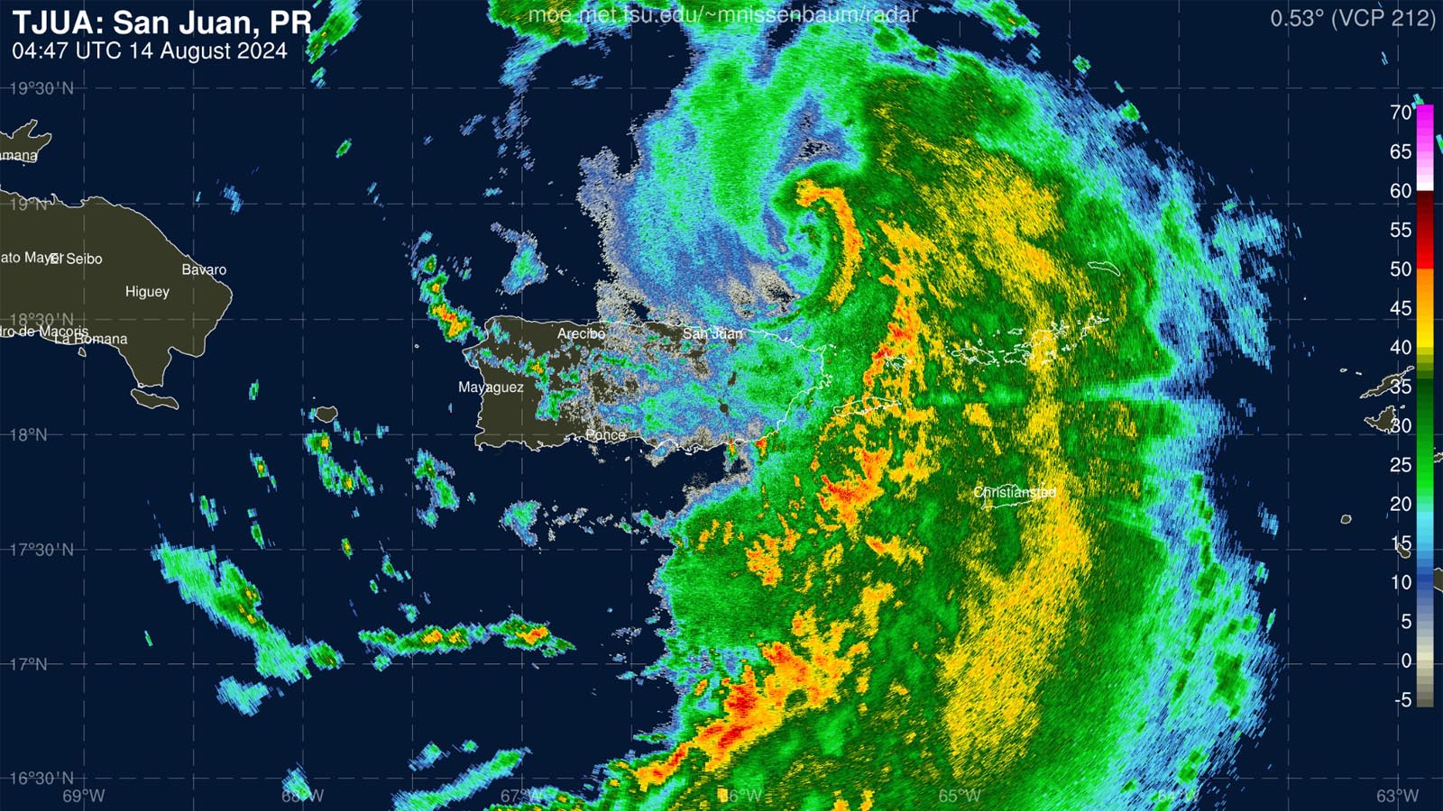
Hurricane Ernesto roared through the U.S. and British Virgin Islands on Tuesday night as a strong tropical storm, bringing torrential rains and wind gusts near hurricane strength to much of the Leeward Islands, Virgin Islands, and eastern Puerto Rico. The storm got a boost from record-warm ocean waters made more than 50 times more likely by human-caused climate change, according to a tool released today by Climate Central, a nonprofit research organization.
At 11 a.m. EDT Wednesday, Ernesto was upgraded to a Category 1 hurricane with 75 mph winds with a central pressure of 991 mb, making it the season’s third hurricane after Beryl and Debby. From 1991 through 2020, the average formation date of a third Atlantic hurricane was September 7.
Early Wednesday morning, the National Hurricane Center, or NHC, said that a WeatherFlow station on Culebra, Puerto Rico, reported a sustained wind of 68 mph, gusting to 86 mph. Roosevelt Roads Naval Station in eastern Puerto Rico reported a sustained wind of 48 mph, gusting to 74 mph. A NOAA Saildrone located about 65 miles north-northeast of San Juan, Puerto Rico, reported a sustained wind of 61 mph gusting to 76 mph.
Heavy rains of five to seven inches have fallen over much of the U.S. and British Virgin Islands as of 10 a.m. EDT Wednesday morning, with up to nine inches in eastern Puerto Rico. An additional four to six inches is expected in southeastern Puerto Rico (see Tweet below).
At 11 a.m. EDT Wednesday, Ernesto was centered about 175 miles northwest of San Juan, Puerto Rico, moving northwest at 16 mph. Tropical Storm Warnings covered Puerto Rico and the U.S. and British Virgin Islands. Satellite imagery showed a steadily organizing storm, with a large and growing field of showers and thunderstorms (convection). Dry air on the hurricane’s west side, injected by westerly upper-level winds causing moderate wind shear of 10-20 knots, was keeping convection weaker on that side.
Ernesto’s big waves
Ernesto is a large storm with tropical storm-force winds that extend out up to 230 miles from the center and hurricane-force winds that extend out 35 miles. By Friday, NHC predicts that this hurricane-force wind field will expand, extending out up to 115 miles from the center. This large wind field will generate some big waves, causing dangerous swimming conditions at beaches late this week and early next week along most of the Atlantic shore of the U.S. and Canada (Fig. 1).


Intensity forecast for Ernesto: Cat 2 likely, maybe Cat 3
Ernesto will continue tracking over near-record-warm sea surface temperatures of about 29 degrees Celsius (84 degrees Fahrenheit), which is roughly 1 degree Celsius (1.8°F) above average for mid-August. According to the Climate Shift tool for ocean temperatures from Climate Central, the record-warm ocean temperatures that Ernesto experienced on its approach to the Lesser Antilles Islands were made over 50 times more likely by human-caused climate change (Fig. 2).


Wind shear is predicted to mostly be moderate (10-20 knots) over the next couple of days. Ernesto will be in an environment with some dry air, so the shear could be problematic for the storm at times. Ernesto is predicted by the National Hurricane Center to peak as a low-end Category 3 hurricane with 115 mph winds on Friday, then gradually weaken.


Track forecast for Ernesto: Bermuda and Newfoundland at risk
Ernesto will pass near Bermuda on Saturday, which will very likely receive at least tropical storm-force winds from the large storm. Whether Bermuda gets a damaging hit by the eyewall of Ernesto will depend on subtle deviations in the northward track, which will be shaped by upper-level features yet to be solidified in forecast models.
A trough of low pressure passing to Ernesto’s north is expected to turn the hurricane more to the northeast early next week, and the storm is a potential threat to eastern Nova Scotia and Newfoundland, Canada.
Typhoon Ampil could pass very close to Tokyo as a major typhoon
The world’s largest city – Tokyo, Japan, with a metro area of 39 million – may have a close encounter with a dangerous typhoon late this week. Tropical Storm Ampil will be rapidly intensifying as it heads north toward Japan, then is predicted to take a sharp right turn near or just east of Tokyo on Friday local time. In its early-morning (6Z) Wednesday run, the HWRF model has Ampil as a Category 2-3 equivalent around the time of that sharp turn, while the HAFS-A model brings Ampil to Category 4 strength just before the turn.
The ensemble model consensus is for Ampil to make its turn just offshore, which would subject Tokyo to torrential rains and strong winds but keep the metro area on the weaker left hand (west) side of the typhoon. But a few ensemble members track Ampil directly over Tokyo, so this typhoon will bear close watching. Typhoons Faxai and Hagabis, striking only a month apart in 2019, inflicted some $27 billion (2019 USD) in combined damage across Japan as they affected the Tokyo area after peaking at Cat 4 and 5 strength, respectively.
Updates to the forecasts for Ernesto and Ampil will occur within this post on Thursday, when we will be publishing our monthly weather/climate summary for July 2024.
We help millions of people understand climate change and what to do about it. Help us reach even more people like you.
Source link


