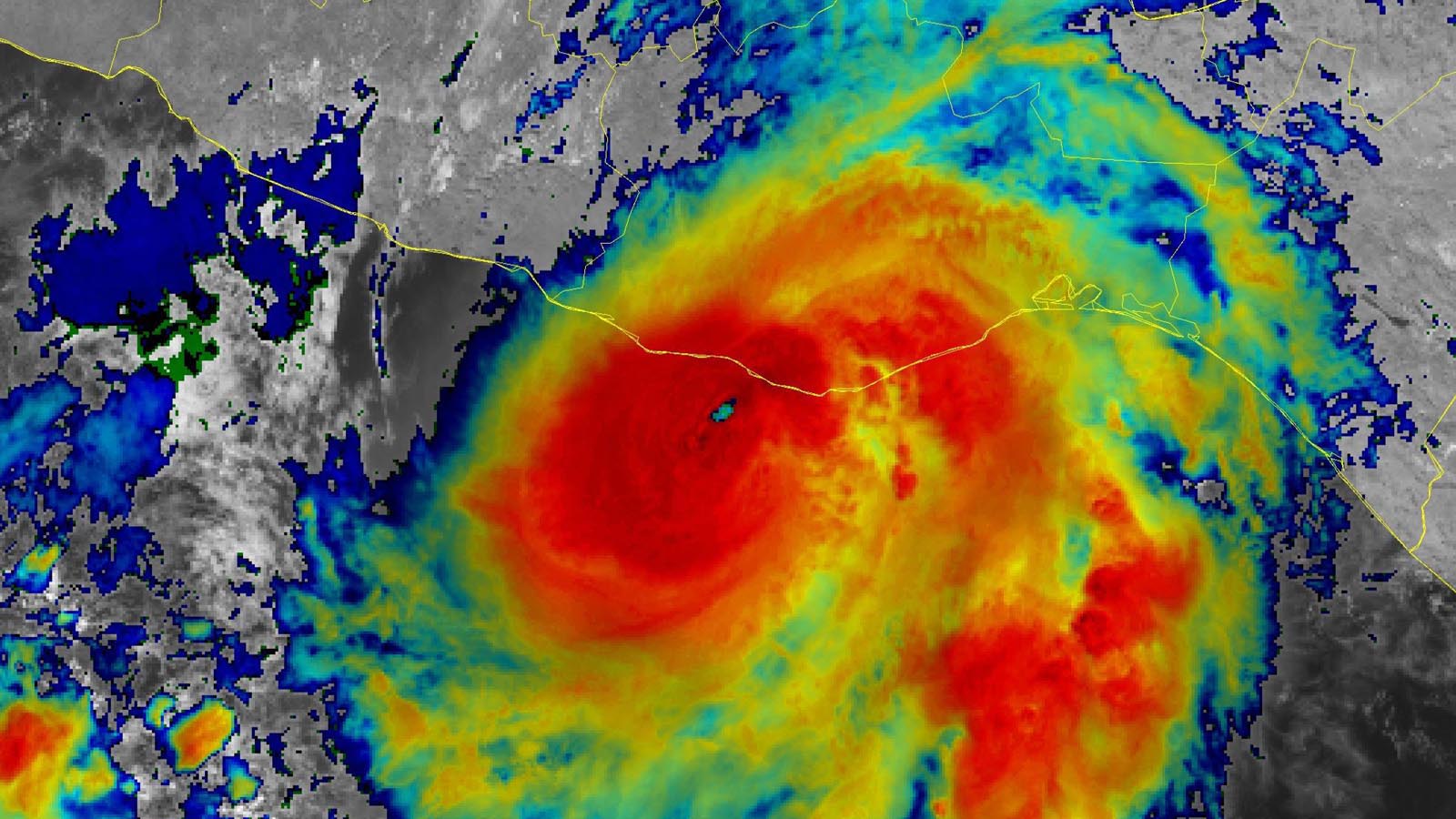
Hurricane Agatha is closing in on the coast of southern Mexico, with landfall expected Monday afternoon or evening as a rare early-season hurricane. At 11 a.m. EDT Monday, Agatha was located about 50 miles southwest of Puerto Angel, Mexico, moving northeast at 8 mph with top sustained winds of 110 mph and a central pressure of 964 mb. A hurricane hunter aircraft was in Agatha, and its 11:02 a.m. EDT Monday center fix found that the hurricane was likely weaker, with a central pressure of 979 mb and an eyewall that was open to the south. Additional weakening is possible before landfall as Agatha interacts with the landmass of Mexico.
Hurricanes are uncommon in May in the eastern Pacific, with 14 on record over the 51-year period 1971-2021. May landfalling hurricanes are very rare in the eastern Pacific. NOAA’s hurricane history database lists only two: a previous incarnation of Hurricane Agatha on May 24, 1971 (85 mph winds at landfall), and Hurricane Barbara on May 29, 2013 (80 mph winds at landfall). Agatha has the potential to be the strongest landfalling Pacific hurricane on record so early in the year.
Storm chaser Josh Morgerman is in Mazunte, Mexico, and is tweeting his observations of the storm.


Agatha’s remnants may bring year’s first Atlantic named storm
Agatha is expected to dissipate over the high terrain of Mexico about a day after making landfall, but remnants of the storm will be caught up in a southwesterly flow that will bring the storm’s moisture and spin over the southern Gulf of Mexico and western Caribbean on Wednesday and Thursday. A number of the ensemble members of the GFS and European models show Agatha regenerating into the Atlantic’s first named 2022 storm in the Atlantic by the end of the week.
If Agatha maintains a well-defined circulation and reform in the Atlantic, it would retain the name Agatha. However, it currently appears that a well-defined circulation will not survive crossing Mexico’s rugged terrain, so any storm that formed from Agatha’s remnants will likely be named Alex. In its 8 a.m. EDT Monday Tropical Weather Outlook, NHC gave five-day odds of Atlantic tropical cyclone formation of 40% to Agatha’s remnants.


Preliminary forecasts suggest that any storm that does form late this week in the Gulf or western Caribbean would experience high wind shear and dry air on its west side. That result would give the storm a more subtropical appearance, with the strongest winds spread out and not concentrated near an intense inner core. Such a system would likely be incapable of rapid intensification, and would primarily be a heavy rain threat.
Heavy rains from Agatha’s remnants are likely to begin affecting Cuba on Thursday, and South Florida and western Bahamas on Friday. The 0Z Monday run of the European model predicted that Agatha’s remnants would bring 7-day rainfall amounts of 6+ inches to portions of Mexico, Cuba, South Florida, and the western Bahamas by Monday, June 6 (Figure 2). The GFS model predicted a rainfall pattern shifted more to the south, with Cuba and the central Bahamas receiving 7-day amounts of 6+ inches, and South Florida no more than three inches.
Bob Henson contributed to this post.
Website visitors can comment on “Eye on the Storm” posts (see below). Please read our Comments Policy prior to posting. (See all EOTS posts here. Sign up to receive notices of new postings here.)
Source link