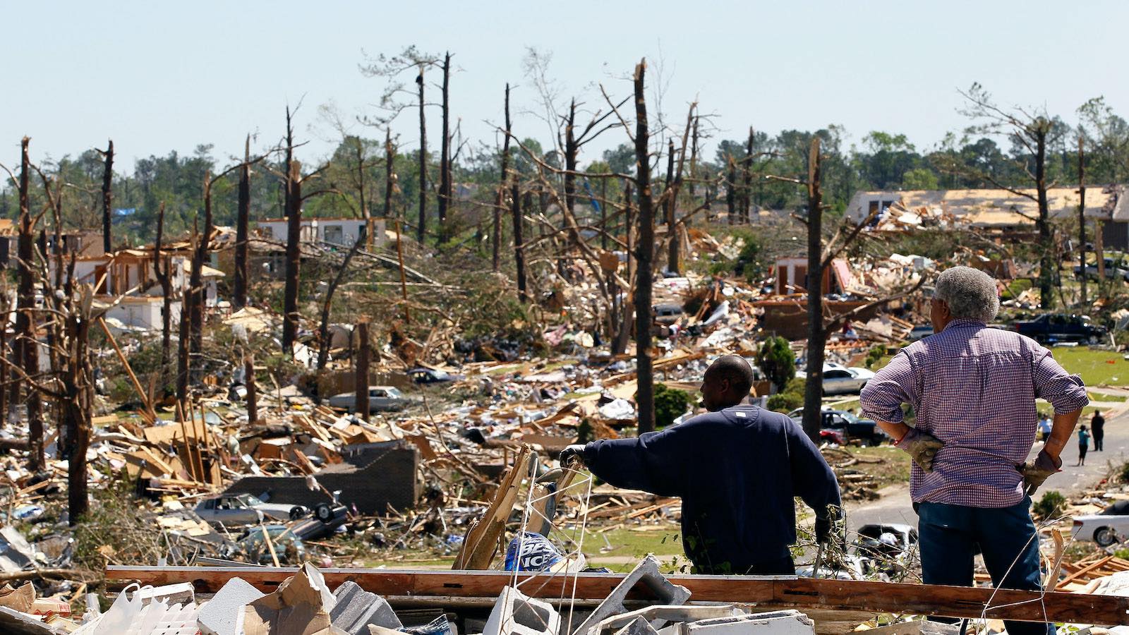
By any yardstick, the 1974 Super Outbreak of severe weather was a nation-rattling event. A total of 148 fast-moving tornadoes rampaged through the central and eastern United States and southern Ontario half a century ago, on April 3-4, 1974. The outbreak included a record total of 30 violent tornadoes, rated the equivalent of EF4 and EF5 on today’s Enhanced Fujita scale.
Although warning and communication processes were sophisticated for the time, they were primitive by today’s standards, and people were far less tornado-savvy. More than 300 people died, and the destruction was immense. One silver lining: storm surveys carried out by Dr. Ted Fujita resulted in the discovery of microbursts and the subsequent creation of an airport warning system and pilot training that have saved countless lives.

The only comparable event in modern U.S. history to the 1974 Super Outbreak was the 2011 Super Outbreak, centered on April 27-28. It took a similar human toll (324 tornado-related deaths) and left a similarly vast footprint of damage, though skewed more toward the South.
If the next super tornado outbreak arrives on roughly the same timeline as the last two, we’d expect it in the 2040s. But tornadoes are famously sporadic, and big U.S. tornado outbreaks have been changing in recent decades – trending away from the Great Plains and toward the highly vulnerable Mississippi Valley and Southeast and making up a larger share of all tornado activity. There’s no guarantee the next super outbreak will adhere to any timeline or behave like the ones that preceded it.
We asked two seasoned meteorologist-researchers to weigh in on how changes in climate and society might shape how the nation experiences its next truly top-end tornado outbreak. Below are their thoughts, followed by our own recollections of the 1974 Super Outbreak.
The big concern about the next super tornado outbreak, in two maps

Dr. Marshall Shepherd is the Georgia Athletic Association Distinguished Professor of Atmospheric Sciences and Geography and director of the Atmospheric Sciences Program at the University of Georgia. He is a former president of the American Meteorological Society and hosts the Weather Channel’s Weather Geeks podcast. He is a senior contributor to Forbes.com and a member of the National Academy of Sciences, National Academy of Engineering, and American Academy of Arts and Sciences.
The formal definition of “tornado outbreak” remains elusive in the scholarly literature, but it is one of those “you know it when you see it” things. The 1974 Super Outbreak is one of those events. It spawned nearly 150 tornadoes from the Deep South to the Great Lakes region and resulted in hundreds of fatalities. The 2011 Super Outbreak is also etched in our collective minds, with over 175 tornadoes spanning a significant portion of the eastern U.S., particularly the geographic region known as the Deep South.
Scholars have recently reported significantly increasing trends of tornado reports and favorable tornado environments in portions of the Southeast and Midwest. Such regions were ground central for two of the worst tornado outbreaks in history, and trends emerging from the peer-reviewed literature are ominous. As we consider how the outbreaks of the past would play out today, two maps and their associated implications keep me up at night.
The first map is from the U.S. Census. It shows percent change in county population from 2010 to 2020. Demographers and anyone driving in traffic regularly will recognize that the South and parts of the Midwest have experienced significant growth. Further analysis reveals that much of that growth is in larger urban centers. Researchers at Northern Illinois University have discussed something called the “expanding bull’s-eye effect.” It is defined on their website in the following manner:
“Targets”—i.e., humans and their possessions—of geophysical hazards are enlarging as populations grow and spread. It is not solely the population magnitude that is important in creating disaster potential, it is how the population and built environment are distributed across the landscape that defines how the fundamental components of risk and vulnerability are realized in a disaster.

As a kid, I remember hearing myths that tornadoes cannot hit cities. As a meteorologist, I have spent time dispelling that myth. In fact, there are numerous examples of large urban areas being struck by tornadoes. The expanding bull’s-eye effect will expose more infrastructure to these powerful storms.
The other risk embedded within the first map is that it likely reflects migration of tornado-inexperienced people to geographic regions that are prone to severe weather. Concerning recent population trends from 2021 to 2022, Pew Trusts.org writes, “The slowdown was especially pronounced in the Northeast and Midwest, while the South and West were home to the fastest-growing states. Warmer climates, vibrant economic activity, and less-expensive real estate have been identified as factors driving population growth in the southern half of the country.” It is not unreasonable to assume many of these residents have not experienced a tornadic storm or have the same “muscle memory” that natives of severe weather regions do. When I moved from Florida to the Washington D.C. area, it took me several years to acclimatize to winter storm risks or planning, and I still probably did certain things incorrectly.
The other map that worries me is the U.S. social vulnerability index. The Centers for Disease Control and Prevention and other institutions track measures of social vulnerability. A CDC website refers to social vulnerability as “the potential negative effects on communities caused by external stresses on human health.” In a study conducted by my research group at the University of Georgia, we assessed the state’s climate risk, including social vulnerability as characterized by various socioeconomic variables.

The map at right, from earlier work at the Earth Institute at Columbia University, illustrates a high degree of social vulnerability (blue) in the South. This distribution encapsulates a population comprised of significant Black, Hispanic, elderly, and impoverished communities. The U.S. National Climate Assessment reports (including the most recent, in 2023) have fervently warned that such communities have the greatest sensitivity to extreme weather events and less capacity to bounce back from them.
It is not a matter of if, but when. The next Super Outbreak looms. Now is the appropriate time to continue to initiate new residents to proper tornado planning and adaptation. Additionally, exposed (and future) infrastructure will need to be resilient to the “new normals” of our weather. For example, Villanova geographer Stephen Strader and colleagues have documented housing vulnerabilities to tornadoes in the South. As for people, better weather models or radars are only part of the solution. The wealth gap in these regions must be closed to reduce vulnerability and enable greater adaptive capacity when the storms inevitably come.
Q&A: How trends already taking shape might influence the next super tornado outbreak

Dr. Victor Gensini is an associate professor in the Department of Earth, Atmosphere, and Environment at Northern Illinois University. His research umbrella covers a wide range of topics related to severe weather, particularly the relationship between severe convective storms and climate change by utilizing dynamical downscaling from a convective-permitting regional climate model. His current focus is examining weather and climate dynamics that explain variability in the frequency of extreme weather (e.g., hail, tornadoes, heavy rain, heat waves) and analyzing ways to forecast these events at sub-seasonal to seasonal time scales. The interview below with Bob Henson has been lightly edited.
Bob Henson: How do you think the climate of the mid-21st century could shift the odds as to where and when another Super Outbreak might take shape?
Gensini: “Super” tornado outbreaks are really at the upper, upper echelon of severe convective storm events, accounting for such a small percentage of the overall total. But indeed, they are the most important, because in general, they have the largest damage footprint.
I’m not 100% sure that anybody’s looked at the future of the most extreme severe weather days, but I can tell you that regardless of what those small percentages show, we will have more damage in the future due to more impacts from these types of events. As we put more bull’s eyes on the dartboard from a growing human-exposure perspective, if we had another super outbreak like the ones in 1974 or 2011, it’s going to be more impactful from a societal perspective. It’s simple: there will likely be more assets in the way.
From a climate-change angle, we should anticipate that the higher end of the distribution of these outbreak days would become more frequent, and the ones that occur would be more intense. And I say that from an instability perspective. For a large-scale outbreak, we need a significant amount of real estate across the country to exhibit a warm sector … essentially a significant amount of instability over a large area. Then as the storms translate, they can take advantage of that instability. Future projections of climate suggest a significant increase in that instability, and it’s projected to be available earlier in the season.
I think this year is unfolding as a good example of what climate change might look like in terms of severe weather frequency. States here in the Midwest experienced one of their warmest winters on record. That translated into little snow on the ground, warmer temps, and we got into severe weather season in the Midwest in February, including a significant tornado in southern Wisconsin. We had multiple rounds, I think 6 or 8 days throughout February and March, that had tornadoes in Illinois, including an EF1 that passed a quarter mile from my house. (I was traveling. Go figure!)
How much of the warm winter was due to El Nino? How much was due to climate change? That’s hard to tease out. But I don’t think there’s anyone who would stand up and say we’d see fewer or less frequent tornado outbreaks in future springs. None of the projections I’ve seen would support that.
In 1974, daily severe thunderstorm outlooks from the National Weather Service extended out just one day. Now they go out to nine days. How much notice of a potential super outbreak could you foresee us getting by midcentury from such weekly or multiweek outlooks or even seasonal outlooks?
When we get these incredibly powerful outbreaks, they are usually easy to spot, in that forecasters are looking for a very specific atmospheric configuration. You need the big powerhouse upper-level trough coming out over the Rockies, with lots of dynamics, and tapping lots of instability. I think in that respect, these larger systems in the early spring are easier to forecast. We can anticipate them with skill days to even weeks in advance in some cases. The difference between a day with multiple tornadoes and a true “super” outbreak comes down to whether or not you get long-track tornadoes, and that can be hard to tell even one day in advance. But signals for a really active period – say, two weeks from now? We can now anticipate that with some skill.
So we’re able to get past the traditional limitations to daily weather forecasting that result from chaos and the “butterfly effect?”
Exactly. A general forecast based on a single model, like the GFS, of severe weather beyond eight days is not going to be very helpful. But if you leverage some of these other statistical techniques and machine learning and so on, what we’re really hoping for is to have a window of enhanced predictability. We’re calling these events “forecasts of opportunity.” They’re not always there, but sometimes when they are, we can make skillful predictions two to three weeks in advance. Of course, that’s really helpful from an emergency management perspective, for insurance/reinsurance companies impacted by loss, and so on. The challenge is that this level of skill is just not always there. For example, summertime thunderstorms are mesoscale in nature and much more challenging from a forecasting standpoint, so a lot of these forecasts can only be issued in the spring.
So this could be in the form of a sporadic, special outlook, rather than a daily operational product?
These would be targeted. Something akin to “beware, two weeks from now, we’re moving into a favorable tornado outbreak regime.” I don’t really envision we’ll have standard Week 3 tornado outlooks anytime soon. I think we’ll have regular Week 2 outlooks at some point, and I think these would be aggregated for the entire Week 2 period, not a specific day. A lot of times, as with Day 8 outlooks now being issued by SPC [the NOAA/NWS Storm Prediction Center], it’s going to say “predictability too low.” But there will be times when we anticipate moving into a window of enhanced predictability at Week 2 and Week 3, and those will be the important events to forecast skillfully.
Read: Climate change and tornadoes: What’s the connection?
Reflections on the 1974 Super Outbreak from Eye on the Storm’s co-writers

Jeff Masters: That event had a major impact on me. The sirens sounded multiple times that afternoon in Southeast Michigan, and we had several damaging tornadoes pass close by, including one that hit Detroit and Windsor, Ontario. The morning after the outbreak, we had an assembly at my junior high school where a Detroit TV meteorologist spoke, and his excitement and concern about the outbreak were riveting.
I went home after school and found out that my dad was very anxious that he hadn’t heard from his parents and his sister’s family, who lived in Monticello, Indiana. Monticello had received a direct hit from an F4 tornado with the longest track (109 miles) of the outbreak, and it killed 18 people and caused over $100 million in damage. My relatives were unhurt, but my grandparents’ home was severely damaged and condemned. I went down a few weeks later to visit and was stunned by the destruction – the historic courthouse destroyed, twisted trees everywhere, and volunteers on the street collecting donations for the homeless. I was an impressionable 13-year-old interested in Earth science, and the experience had a galvanizing influence on my decision to pursue a career as a meteorologist.

Bob Henson: Like many of you, I’ve found that some weather events – even if they don’t directly affect me – burrow deep into my consciousness and stay lodged there from that point onward. I think this is especially true for major weather disasters that happen when we’re young. That’s the case for me with the 1974 Super Outbreak. I lived in Oklahoma City, well to the west of the outlook area, so I wasn’t personally alarmed. But the news of the eventual outbreak intensified my already keen interest in severe weather.
I was still in junior high school at this point, but already an avowed weather nerd as well as a budding news junkie, so of course I watched the weather segment on NBC’s “Today” show that morning. In this pre–Al Roker, pre–Willard Scott era, the weather on “Today” was presented über-simply: just a map or two, together with commentary from the stolid news anchor, Frank Blair. On the morning of April 3, I could tell something was up. Blair’s low-key tone seemed to be just a notch higher, and the map he showed had a huge crosshatched area covering much of the eastern U.S., together with an all-caps label I’d never before seen – something akin to “NUMEROUS SEVERE THUNDERSTORMS.” Which, of course, proved to be both a spot-on forecast and a startling understatement.
We help millions of people understand climate change and what to do about it. Help us reach even more people like you.
Source link