I very quickly realized that the act of chasing storms is much more difficult than I could have ever imagined, especially solo. The sheer amount of driving time and analytical second guessing can cause self-doubts in anyone about the entire grueling endeavor. It is an experience filled with numerous rather “low lows,” and a few extremely “high highs.” And having now seen the first of what could be more tornadoes still yet to come, for me anyway, it’s been entirely worth it. 100% worth it.
Waking up that early May day on the border between western Oklahoma and the Texas panhandle, the morning weather surprised me. Immense calm filled with dense fog, rendering obscure the other side of the small lake. Not super-conducive for tornadoes, and could I see them in any event? This feeling stayed with me for much of the day, as did the fog. I later realized the folly of that thinking, remembering that the atmosphere is changing every instant. And that the biggest changes often happen during daylight hours, when an incredible amount of solar radiative energy added to the atmosphere literally stirs things up … and burns off fog.
This early fog didn’t deter the National Weather Service’s Storm Prediction Center. Scientists there had issued the second highest warning level on a 5 point scale (MODERATE) anticipating all potential severe hazards (flooding rain, large hail, and potentially strong tornadoes) for a large area of north central Texas and southwest Oklahoma.
Within large low-pressure systems like the one approaching me that day, the boundaries of different air densities, temperatures, and moisture content serve as initiation points for severe storms. The interplay of these always-changing variables within those boundaries mixes influencing their own and neighboring particles based on thermodynamics and fluid flow. The particular storm system that day featured a highlighted area of risk called the ‘dryline’: a usually north-to-south oriented boundary of warm/dry and warm/humid conditions.


I headed out for my first target area just inside the Texas border and passed through a drought-ridden landscape. While bulletins on church signs asked people to ‘pray for rain’ this seemingly fertile valley of brilliant green, striped through the red Texas dirt, on that morning at least offered a calming moment. It ended up being the only real one of the day. As I admired the silent landscape from an overlook before descending through the valley, I noticed two dead calves to my right, omens of the harshness of even the most beautiful vistas.


While I was parked at a gas station in Shamrock, Texas, eating a slice of deep-fried pepperoni pizza (a wonder of nature in its own right) and looking at computer models and graphical/satellite analysis, the day’s first thunderstorm cells started to fire nearby to my west, moving northeast. It was still pretty early in the day, but the spacing and depiction of these storms aligned somewhat with one of the best of the “day of” models, the HRRR. I was hooked, and my excitement for any storms overpowered any ability to wait and see how the larger situation farther south would play out. Upon nearing the storms, I parked in the driveway of an abandoned farm house and got out of my van, realizing quickly my need for a sweater. That thought set off alarm bells in my head: Cold air is the opposite of what a severe storm needs to sustain itself. Even though nothing had yet formed farther south, I gave up on these storms and started to head down the panhandle.
About an hour down the road, I lowered my window and stuck my hand out: The air now was warmer, more moist. I stepped from the van to get a better sense of the atmosphere around me and found a lone supercell sprouting up about 50 miles to my southwest, essentially moving toward me. From my experience with a cell in Arkansas weeks earlier, I knew to avoid getting stuck to the north of a severe cell: It was important to get south of the storm. I caught a glimpse of it right as it performed its first obvious atmospheric magic of splitting into two different cells, just like in biology. Within the atmosphere, this splitting most commonly occurs as one cell peels off and moves generally northward, the remaining one moving generally eastward.


I watched this split take place with a storm chaser named Brandon, from Nebraska, who said he’d been chasing for 13 years but has a day job working at a pharmaceutical company. Seeing someone else chasing and chatting excitedly as we both analyzed and watched the storm was my first real shared moment with another chaser. It illuminated just how unique a field this is, and how incredible it is that many are drawn from all over to experience these phenomena. Like moths to a flame. “Street smart” from having observed numerous storms first-hand, he had gained deep first-hand insights.

As the storm started to look more ominous and cloud-to-ground lightning intensified (a sign of a strengthening storm) Brandon and I parted ways, opting for different approaches to staying ahead of it.
I headed east to get to a north-south highway where I could easily watch the approaching supercell. When I got to the isolated highway I was flabbergasted to see dozens and dozens of vehicles lining it, turning a normally desolate farm road into a teeming amphitheater of weather nerds watching a free show. This notion of chaser convergence doesn’t always happen but when it does, creates a chaotic scene both beautiful in its culminating principle of collectively observing nature and its power, yet terrifying in its ability to create a sometimes incredibly dangerous driving situation.
A tornado warning for the storm had just been issued, the squawking alert sounding out in rounds from people’s cell phones. A chunky cloud lowering had established itself on the base of the storm, known as a wall cloud, a usual but not always necessary part of a tornado’s descent from a storm. This foreboding and intimidating progression was accompanied by ping-pong sized hail beginning to fall from the sky. I took cues from an elderly chase couple who had popped open the back gate of their vehicle, sheltered but still able to watch the storm outside, without the risk of head welts, or concussions.

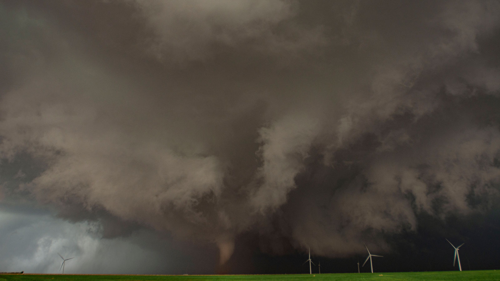
Most of the vehicles began to head south to get ahead of the storm as it began to approach the highway where we all were. I didn’t want to rush too much and miss observing the storm from outside, preferable to continuously driving and staring through the window. But it was a needle to thread to stay in between the rotating wall cloud to the south and the rain/hail core to the north. I succeeded, and as the storm passed to my south, I began to look for east roads to follow it. The map showed but one real road and when I got to it, I followed several other vehicles onto the dirt road, knowing instantly that what I had longed for years to see was at last taking place in front of me.
Look for Part 2 of this story on June 16.
Editor’s Note: Photos and captions in this series by Charlie Randall unless otherwise noted.
Charlie Randall, a photojournalist, one-time meteorology student and, now, an avid storm chaser living in Toronto, is traveling across parts of the U.S. observing extreme weather and its aftermath.
Source link