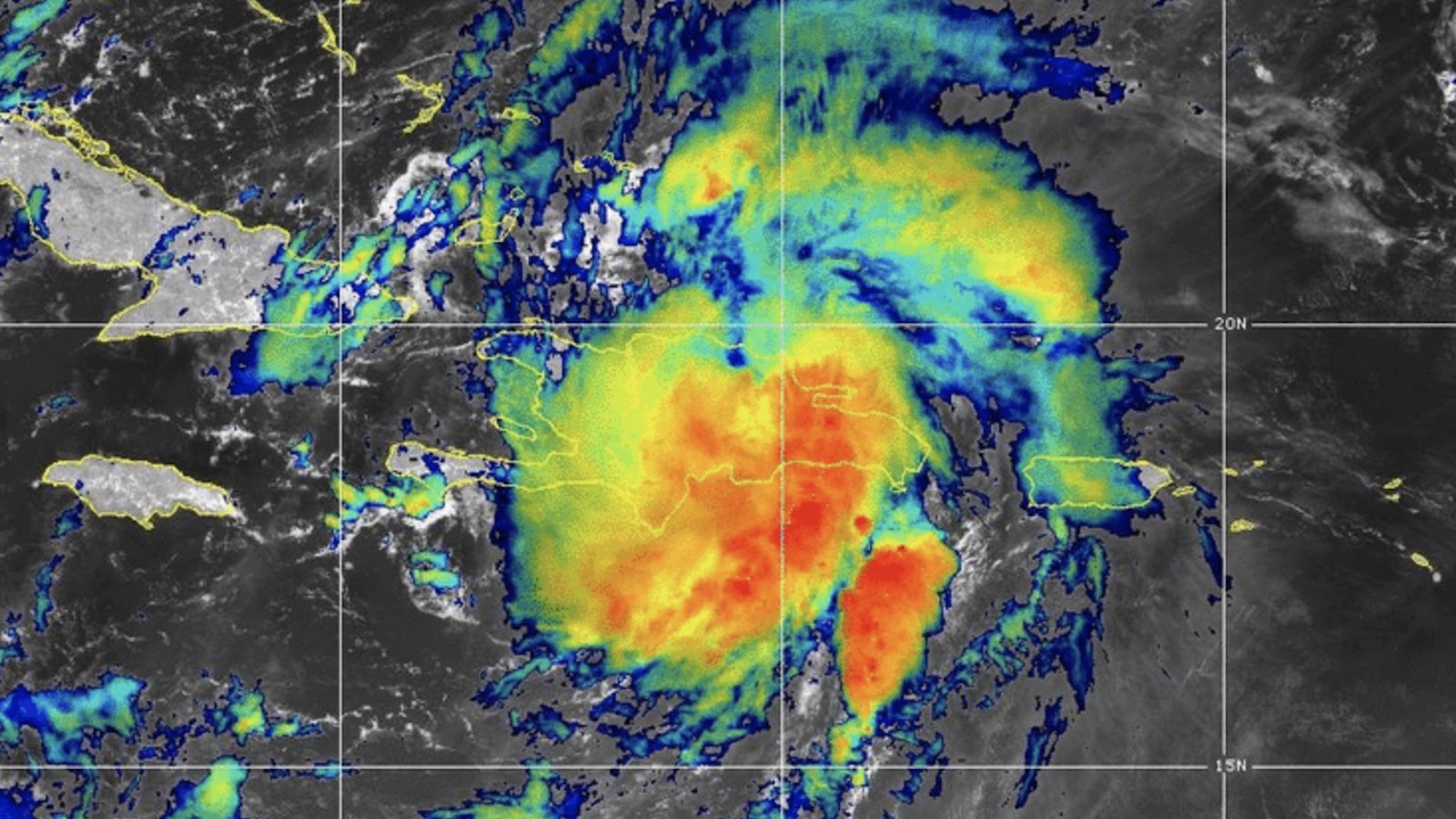
Tropical Storm Franklin slogged onto the south coast of the Dominican Republic on Wednesday morning, bringing heavy rains and squalls to the island nation as well as to adjacent Haiti and nearby Puerto Rico. Franklin made landfall in the Baharona Province of the Dominican Republic around 8 a.m. EDT Wednesday, according to the National Hurricane Center (NHC).
Franklin’s maximum sustained winds at landfall were estimated at 50 mph. Sustained winds of 37 mph were reported at San Miguel, about 60 miles east of the landfall point. At 11 p.m. EDT Tuesday night, Baharona reported a wind gust to 52 mph in squalls on the north side of Franklin.
Intense showers and thunderstorms (convection) covered most of Hispaniola and western Puerto Rico at midday Wednesday. Rainfall totals in the Dominican Republic as of midday Thursday from Franklin, as posted by meteorologist Wagner Rivera from the nation’s meteorological service, included 240.8 millimeters (9.48 inches) at Enriquillo, Baharona, and 164.1 mm (6.46”) at Los Cajuiles, near the north coast. Significant flooding was reported in Manoguoyabo, on the western fringes of the Santo Domingo area.
Forecast for Franklin
Franklin’s sustained winds had dropped to 40 mph by 11 a.m. EDT Wednesday as the storm pushed across Hispaniola. Franklin may weaken to tropical depression status before or just after it moves offshore, given the effects of its land interaction. However, there may be a long life ahead for Franklin, as it is expected to reintensify over the unusually warm tropical and subtropical waters north of Hispaniola. In fact, storms that are less organized over Hispaniola sometimes have an easier time restructuring themselves after passing over the island’s rugged island.
Forecast models and the National Hurricane Center agree that Franklin will arc slowly northeast and east from late Thursday into Friday, then angle sharply back toward the north-northwest and pick up speed over the weekend as a blocking high intensifies east of Franklin. As Franklin makes its northward break this weekend, it will likely embark on what could be a prolonged bout of intensification. Wind shear should finally relax to the light-to-moderate range (5-15 knots) by Saturday, and the waters below Franklin will remain in the ballpark of 29-30 degrees Celsius (84-86 degrees Fahrenheit), with substantial oceanic heat content at deeper levels.
Forecast models are in strong agreement that Franklin will reach hurricane strength by Saturday, as predicted by NHC, and continued intensification is quite possible. The new HAFS (short-range model) has suggested in multiple runs that Franklin could be a major hurricane as soon as Sunday, perhaps even reaching category 4 strength. Franklin will be at the latitude of Bermuda by around Monday; ensemble models suggest that Franklin is most likely to move just to the west of the island, but there is ample track uncertainty in that time frame, so Bermudians will need to keep a close eye on Franklin.

Emily may regenerate over the remote Atlantic
Former Tropical Storm Emily, which was born on Sunday and declared post-tropical just 24 hours later, appears to have a second lease on life. Strong convection has been disorganized but persistent just east of a well-defined low-level center marking the remnant circulation of Emily at around latitude 27 north, longitude 49 west. Winds near or above gale-force strength have been observed in a broad area northeast of the remnant low, and if the convection can shift over the low-level center, Emily may again be declared a tropical storm (keeping its original name, since the remnant low has remained distinct).

Wind shear will be decreasing sharply over Emily on Thursday night, and the system remains over unusually warm subtropical waters of 28-29°C (82-84°F), with a mid-level atmosphere moistening to around 60-65 percent relative humidity by Friday. Ensemble models give strong support for Emily’s redevelopment, and the HAFS-A model suggests that Emily could be a hurricane by Friday. In its 2 p.m. EDT Wednesday Tropical Weather Outlook, NHC gave Emily 2- and 7-day odds of redevelopment of 60 and 70 percent, respectively. Emily will remain over the remote North Atlantic, posing no immediate threat to land.
A poorly organized disturbance in the far eastern tropical Atlantic west of the Cabo Verde islands, designated Invest 92L, will be angling west-northwest, and is eventually likely to recurve in the oceanic footsteps of Emily. NHC gives this system a 10 and 30 percent chance of development over the next two and seven days.
Will this year’s Atlantic hurricane action keep avoiding the tropics?
Thus far in 2023, there has only been one Atlantic hurricane, Don, which briefly attained minimal hurricane strength on July 22 while located at latitude 40.1 degrees North in the open Atlantic. Franklin’s expected surge to hurricane strength may not occur until the storm has moved north of the tropics (defined as the area between latitudes 23.4 south and north), and if Emily becomes a hurricane, it will be well poleward of 30 degrees north. It would be remarkable indeed if the first three Atlantic hurricanes of the year all occurred outside the tropics! It would also be consistent with the tendency during El Niño periods, such as we have now, for hurricanes to be largely suppressed in the Gulf of Mexico and the Caribbean.
Jeff Masters contributed to this post. Website visitors can comment on “Eye on the Storm” posts (see comments policy below). Sign up to receive notices of new postings here.
Source link


