Headlines
- Debby will cause heavy rain and more flooding in parts of the Carolinas today and tomorrow.
- By Friday, Debby’s rain and flooding will expand northward to Pennsylvania, Central New York, and northwestern New England, as well as Quebec.
- The Caribbean wave we were watching has been taken off the board and should not develop.
- We are watching some other areas in the Atlantic later into next week.
- We also introduce our sponsors page!
Debby readying to come back ashore — slowly
You might be confused when looking at Debby this afternoon. It barely resembles a tropical storm. But as has been the case with Debby since it was a tropical wave, it’s the size that really does it. Hurricane hunters found 60 mph winds about 100 miles away from the center, so Debby is currently a large, lumbering tropical storm.
Tropical storm force winds extend out about 185 miles from the center. This also means Debby will have a bit widespread storm surge potential as it makes final approach tonight.
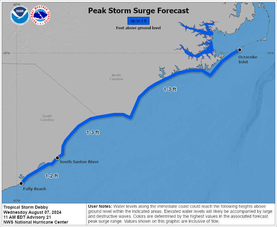
Certainly not the worst surge we’ve ever seen here, but spatially it will cover a wide area. From here, Debby will continue generally north and eventually northeast, accelerating and transitioning into an extratropical storm as it moves out of the Southeast.
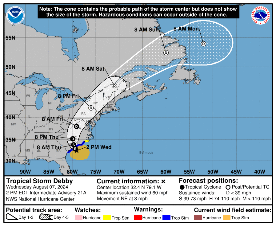
Debby will track through North Carolina tomorrow, into Virginia early Friday, and across Pennsylvania and New York Friday afternoon and evening, into Canada this weekend.
Today’s concerns
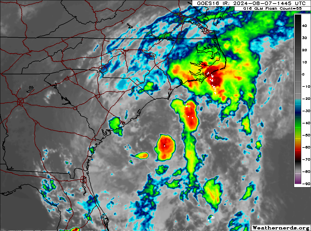
Heavy rain is ongoing again in South Carolina this afternoon. In addition, a couple tornado warnings are in effect in North Carolina as I write this.
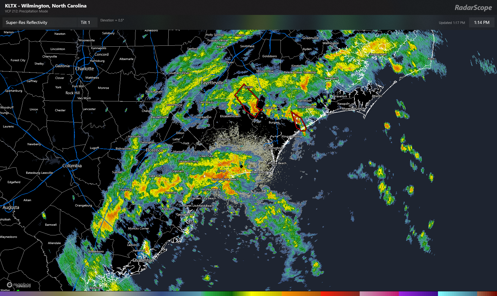
A high risk, level 4/4 of excessive rainfall is in place for much of southeastern North Carolina and northeastern South Carolina today. Some of the rain coming ashore now near North Myrtle Beach is quite heavy, and we’ll probably see flooding begin not too long from now in these areas.
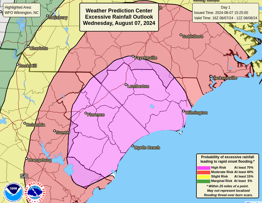
Debby will only slowly come ashore today and tonight, so this rain isn’t going to move a whole ton. Hence why we see the flooding risks beginning to increase now.
Thursday’s concerns
Debby will make an effort to get to the North Carolina border north of Florence tomorrow. This means that rain is only going to gradually expand northward. But that said, we will likely see a high risk again emerge for considerable flash flooding up into central and eastern North Carolina, including Fayetteville, RDU, and parts of the Piedmont.
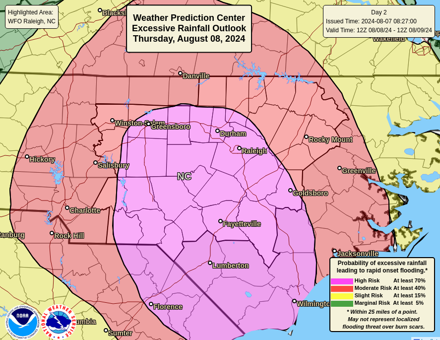
We could easily see 3 to 6 inches of rain anywhere in this region. Higher amounts are possible as well. Rapid onset flash flooding is likely to take place, so limiting travel in this area, and possibly avoiding I-95 south of Rocky Mount isn’t a bad idea tomorrow. Conditions should improve Friday in much of this area.
Friday’s focus comes north
As Debby begins to accelerate north, getting absorbed into an upper atmospheric trough of low pressure Friday and Saturday, its heavy rain will also come northward. We expect to see a period of heavy rain as Debby’s core comes north along the eastern front of the Appalachians across Virginia, Central Pennsylvania, and Central New York. Some of these areas have seen very heavy rainfall recently, and it will take very little for flooding to unfold once more.
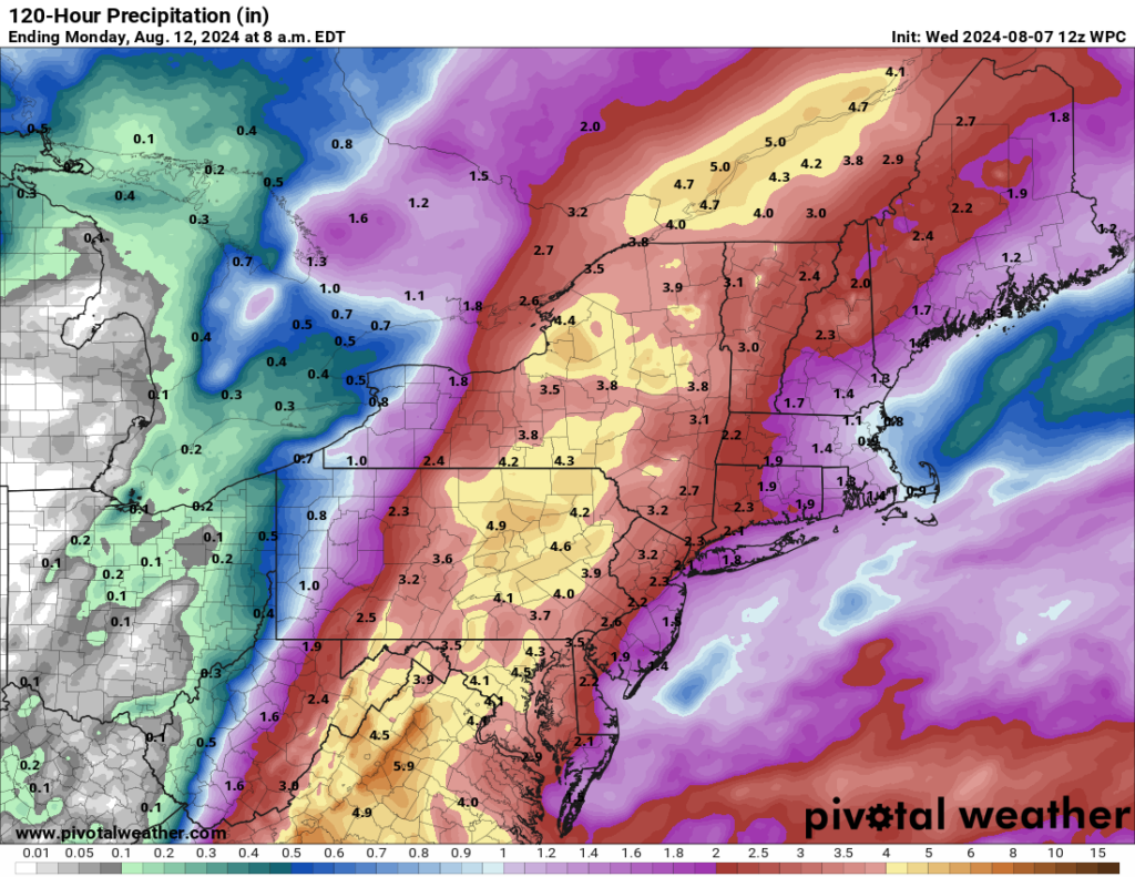
As of now, the moderate risk (level 3 of 4) for excessive rain does not include Philadelphia, New York City, or New Jersey, although some locally heavy rain is possible there too. It does include Harrisburg, Scranton, Syracuse, Utica, and Burlington, among other places. Portions of Vermont are extremely vulnerable to flooding right now, and any shift in Debby’s track could lead to a larger impact there.
From there, Debby heads into Canada, where heavy rain is likely across Quebec and Labrador. The heaviest rain should follow the St. Lawrence across Quebec. with perhaps even some locally heavy rain in Newfoundland’s Great Northern Peninsula. And then Debby will be gone. Goodbye.
Elsewhere in the tropics
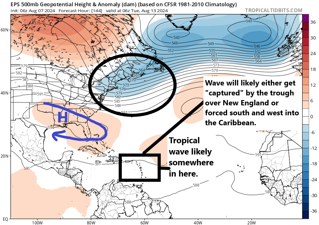
Let’s get you caught up on some other issues in the tropics. First, the area in the Caribbean that we’ve been watching has seen a significant decline in development odds since yesterday. They’ve just been taken down to 0 percent, and as I noted yesterday, high pressure over Texas and the South should keep this wave firmly suppressed south of the Gulf. That’s that.
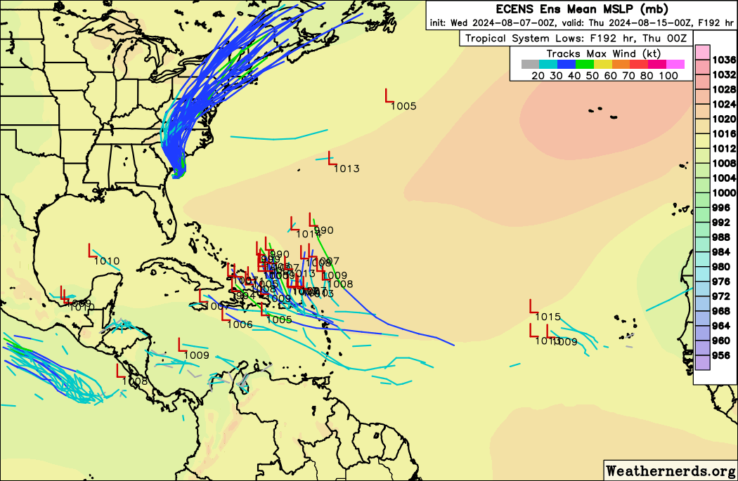
Looking farther east and farther out in time, we’re seeing a signal on European ensemble modeling for potentially two more waves to watch. The first one would arrive in the Lesser Antilles or nearby in about 5 or 6 days. No development is expected out of this one before then. Look for this to perhaps get added to the NHC big board tomorrow if model trends continue. Once in the eastern Caribbean or near the islands, it will sort of be at a crossroads. A weaker system or disorganized wave would probably get forced south and west back into the Caribbean and off to the west by strong high pressure over the South. A slightly better organized system would almost certainly feel the “pull” of the deep trough over New England.

It’s too early to speculate on what is more likely. The Euro ensemble certainly favors the “capture” scenario, but I’ve seen situations like this where the high is a little too strong and forces a southwest motion earlier, avoiding the capture. So I’m basically unsure about this wave. For now, it’s not a concern for anyone, but as is the case in August, check back in a day or two to see what’s changed.
Additional waves may develop off Africa heading into late month, but we don’t have any specific details as of yet.
Sponsors
I want to just highlight our brand new Sponsors page! I want to thank the businesses that have enthusiastically committed to supporting The Eyewall the rest of this hurricane season. I encourage you to check them out to see if their services support your interests or needs. Our readership extends from California to the Caribbean to Canada, but obviously we’re popular in Houston, our home base. If you want to sponsor The Eyewall and support our coverage around the Atlantic Basin, you can contact us from the sponsor page. We will work on a way for individuals to support the site in the future. Thanks as always for your support, and keep spreading the word.
Source link