Two Atlantic tropical rainmakers were threatening to become tropical cyclones on Thursday, June 30. One disturbance, designated 95L by the National Hurricane Center (NHC), was spinning off the South Texas coast. Another disturbance, Potential Tropical Cyclone 2 (PTC 2), was speeding across the southwestern Caribbean. Either system could become a tropical cyclone today, but regardless of what they’re called, their heavy rains will affect a wide swath of coastline.
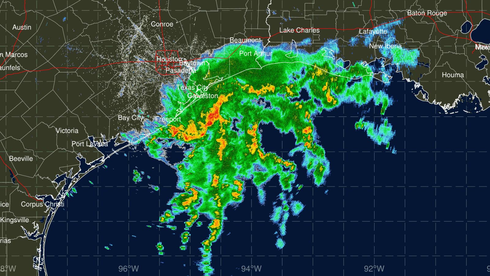
The system of more immediate U.S. interest is 95L. Satellite images on Thursday afternoon showed a modest area of heavy thunderstorms to the northeast of a broad circulation just off the South Texas coast, but there was no well-defined low-level surface circulation. Radar images showed 95L’s low-level bands of precipitation to be poorly organized, with heavy rains affecting the Texas coast near Galveston. A station at Jamaica Beach on Galveston Island recorded 2.72 inches of rain in just one hour on Thursday morning (see Tweet below).
Upper-level winds from the southwest were creating light wind shear of 5-10 knots, pushing dry air into the heart of 95L, and its environment was only moderately moist (relative humidity of 60%). Steering currents are expected to take 95L to the north at roughly 5 mph through Thursday night, bringing the center ashore along the central Texas coast Thursday evening.
Given the weakness of the surface circulation and the expected persistence of wind shear, there is little chance that 95L will undergo rapid intensification. Its main effects on the Texas and Louisiana coasts – heavy rains of 2-4 inches – are likely to be more beneficial than problematic, as the region has been dealing with moderate to severe drought. But some localized flooding is possible, especially in parts of coastal Texas, where isolated rainfall totals could approach or exceed seven inches.


A side benefit of this system is a slight break from the intense heat of this month, which will be the warmest June on record for Houston, Galveston, and College Station.
In its 8 a.m. EDT Thursday tropical weather outlook, NHC gave 95L 2-day and 5-day odds of development of 40%. A hurricane hunter aircraft is to investigate 95L Thursday afternoon.
PTC 2 near tropical storm status
As of 11 a.m. EDT Thursday, tropical disturbance Potential Tropical Cyclone Two (PTC 2) was speeding west at 20 mph away from the northern coast of Colombia across the southwestern Caribbean. This was the 11th advisory the National Hurricane Center (NHC) had issued for the potential tropical cyclone, setting a new record for the longest period of time a system has been classified that way (see Tweet below). PTC 2 was centered about 660 miles east of Bluefields, Nicaragua, with top winds of 40 mph. The broad area of rotation within PTC 2 was beginning to form distinct low-level circulation, but its overall organization did not yet warrant classification as a tropical storm.
Satellite images Thursday afternoon showed that PTC 2 was slowly growing more organized, with an increase in low-level spiral bands and heavy thunderstorms. However, it appeared that some dry air was interfering with development.
The atmospheric and oceanic conditions around PTC 2 will favor strengthening through landfall on Friday night in Central America: light wind shear (below 10 knots), warm ocean temperatures of 28 degrees Celsius (82°F), and a moist midlevel atmosphere (relative humidity 70%). PTC 2 had been hampered from developing a closed circulation through Thursday morning because of its proximity of the coast and its fast rapid forward speed. Both of these factors are now less of an issue, which should help it become a tropical storm by Thursday night. PTC 2 is likely to make landfall on Friday night as a strong tropical storm or weak category 1 hurricane near the Costa Rica/Nicaragua border. The storm is expected to survive crossing Central America and become a tropical storm or hurricane in the eastern Pacific by early next week. When such a system remains an identifiable tropical cyclone while crossing Central America, it retains its original name, a policy in place since 2000.
In its 8 a.m. Thursday forecast, NHC gave PTC 2 2-day and 5-day odds of development of 90%. The next name on the Atlantic list of storms is Bonnie. A hurricane hunter aircraft was investigating PTC 2 on Thursday afternoon.


Tropical wave east of the Lesser Antilles poses little threat
A tropical wave located in the central tropical Atlantic near longitude 53°W on Thursday afternoon was moving west-northwest at 10-15 mph. Satellite images showed that this wave was quite disorganized, and it is headed into an area of high wind shear that will make development unlikely. In a Thursday tropical weather outlook, NHC gave the wave 2-day and 5-day odds of development of 10%.
Bob Henson contributed to this post.
Website visitors can comment on “Eye on the Storm” posts. Comments are generally open for 30 days from date posted. Sign up to receive email announcements of new postings here. Twitter: @DrJeffMasters and @bhensonweather
Source link