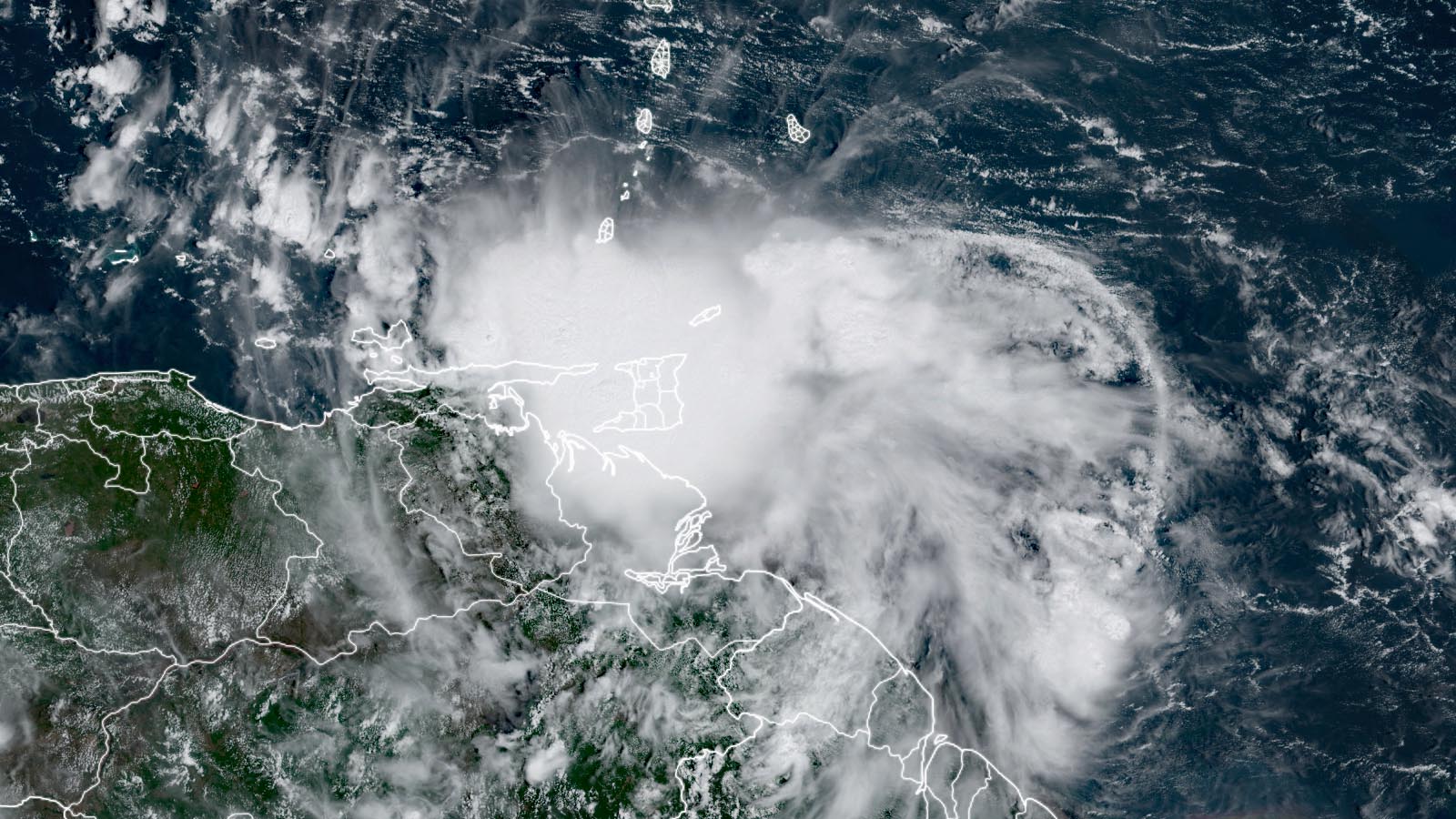
A tropical wave designated Invest 91L was passing through the Windward Islands on Wednesday, headed west at 15 mph. This system has the potential to develop into a named storm that could threaten the southern Caribbean and Central America.
Overnight, 91L brought sustained winds of 36 mph, gusting to 48 mph, to Barbados; a wind gust of 47 mph was reported on Grenada at 11 a.m. EDT Wednesday. Satellite imagery and Barbados radar on Wednesday afternoon showed heavy thunderstorms affecting much of the Windward Islands and adjacent coast of South America. Significant flash flooding was reported in Trinidad and Tobago, where over two inches of rain fell in less than 30 minutes.
91L had a modest-sized area of poorly organized heavy thunderstorms, and a Wednesday morning mission by an Air Force hurricane hunter aircraft showed an elongated area of light winds underneath 91L’s heavy thunderstorms, but no well-defined circulation center. The aircraft measured surface winds of 40 mph, indicating that 91L would already be a tropical storm if it had managed to close off a well-defined surface circulation center.
A ridge of high pressure to the north of 91L will keep it moving on a westward trajectory through early next week. On Wednesday and Thursday, 91L will be moving through the southern Caribbean, its center just scraping the northern coast of South America; interaction with the landmass of the continent likely will interfere with development. Conditions for development will otherwise be favorable, with warm waters near 29.5 degrees Celsius (85°F), light to moderate wind shear of 5-15 knots, and a moist atmosphere (a mid-level relative humidity of 70%). The main threat posed by 91L through Friday will be heavy rains along the coast of South America and the adjacent ABC islands. These rains should be similar in magnitude to what the disturbance that became Hurricane Ian brought last month, about 2 – 6 inches, with the potential for flash flooding. Jamaica and southern Haiti may see rains of 1 – 3 inches of rain from 91L on Thursday and Friday.
91L continues to have strong model support for development, with those odds highest on Friday, once 91L pulls away from the coast of South America and enters the southwestern Caribbean. There is no reason to believe the disturbance will turn more to the north and threaten the northern Caribbean islands or the United States.


Models have come into much better agreement on the forward speed of 91L, with a landfall in Nicaragua on Sunday the most likely prospect – though a more west-northwesterly track and a landfall in Honduras or the southern Yucatan Peninsula on Monday is also a possibility. Assuming no substantial development occurs until Friday, 91L will have just a limited amount of time for intensification before making landfall. Nevertheless, the western Caribbean this weekend is expected to have highly favorable conditions for 91L to spin up into a hurricane, and a number of models show 91L becoming a hurricane in the western Caribbean on Sunday, especially for the more northerly tracks that would give 91L more time over water (see Figure 1).
Even in 91L does not intensify into a hurricane, the disturbance likely will bring dangerous heavy rains of 4 – 8 inches to portions of Central America this weekend, with Nicaragua and Honduras highest risk.
In its 8 a.m. EDT Wednesday Tropical Weather Outlook, the National Hurricane Center gave 91L 2-day and 5-day odds of development of 60% and 80%, respectively. The next name on the Atlantic list of storms is Julia.


Newly-formed Tropical Depression 12 already on its last legs
Born on Tuesday, Tropical Depression 12 may be gone by Thursday. As of 11 a.m. EDT Wednesday, TD 12 consisted of little more than a low-level circulation in the eastern tropical Atlantic, with top sustained winds of 35 mph, and a batch of showers and thunderstorms (convection) well to its east, almost halfway to the Cabo Verde Islands.
As predicted, strong wind shear of 20-30 knots was hammering TD 12 on Wednesday. The shear will rise to more THAN 30 knots on Thursday, so it’s highly likely that that TD 12 will meet its demise and become a remnant low, probably on Thursday. Earlier model suggestions that TD 12 could have a second window for development in the central Atlantic a few days from now have receded.
Please donate to help hurricane victims
To help out with Hurricane Ian or Hurricane Fiona recovery efforts, please consider donating to one of these worthy causes:
The Partnership for Inclusive Disaster Strategies (formerly Portlight.org), helping disabled people recover from the hurricanes.
Website visitors can comment on “Eye on the Storm” posts (see comments policy below). Sign up to receive notices of new postings here.
Source link