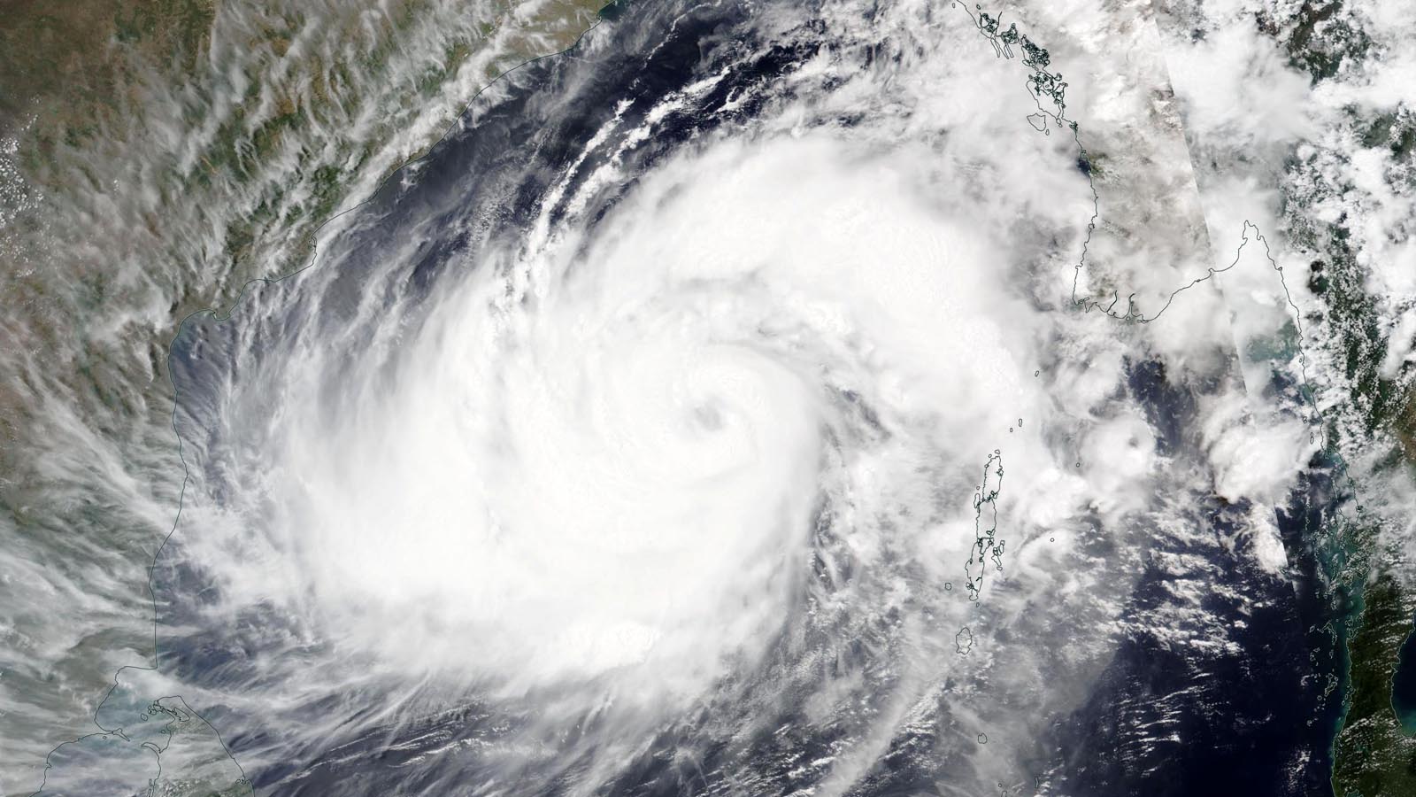
Tropical Cyclone Mocha (pronounced “Mokha”) formed in the North Indian Ocean’s Bay of Bengal Wednesday night and is poised to become a dangerous major hurricane that will make landfall on Sunday just south of the Myanmar-Bangladesh border.
At 8 a.m. EDT (12 UTC), May 12, the Joint Typhoon Warning Center rated Mocha a category 2 storm with 105 mph winds (1-minute average), moving northeast at 7 mph. The India Meteorological Department, the official agency responsible for issuing tropical cyclone forecasts in the Indian Ocean, rated Mocha “very severe cyclonic storm” with peak winds of 87-93 mph (three-minute average). This is equivalent to a low-end category 2 hurricane.
Forecast for Mocha
The track forecast for Mocha is relatively straightforward, with well-defined steering currents expected to take the cyclone to the northeast to a landfall just south of the Bangladesh-Myanmar border on Sunday between 6-9 UTC. Mocha is a large storm, and impacts will be widespread and severe along much of the northwestern Myanmar coast. Bangladesh is expected to be on the weaker (left-front) side of Mocha’s eyewall and will likely see lesser (but still significant) wind damage.
Mocha has favorable conditions for intensification, with moderate wind shear of 10-20 knots, a moist atmosphere, and very warm ocean waters with high heat content. The cyclone is feasting off unusually warm waters — 30-31 degrees Celsius (86-88°F). The warmth is largely caused by a record heat wave that has affected Southeast Asia in recent weeks, which set the all-time heat records for Vietnam, Laos, and Thailand, as well as for the portion of the coast of Myanmar (Rakhine State), where Mocha is expected to make landfall. Weather records expert Maximiliano Herrera characterized the late March–early May period in Southeast Asia as the world’s most extreme long-lasting tropical heat wave on record.
Read: Heat waves and climate change: Is there a connection?
Some slight weakening of the cyclone is possible in the 12 hours before landfall because of declining ocean temperatures; the Joint Typhoon Warning Center predicts that Mocha will peak as a category 3 storm with 125 mph winds Saturday before weakening by 10 mph to a low-end category 3 storm with 115 mph winds just before landfall on Sunday. The India Meteorological Department predicts Mocha will strengthen by about 5 mph compared to its Friday intensity and make landfall with peak 3-minute winds of 93-99 mph, equivalent to a category 2 storm.

Storm surge a major concern
The Bay of Bengal is funnel-shaped and shallow for a large distance from the coast, which makes it prone to large storm surges. Some of the deadliest weather disasters in world history have occurred because of catastrophic storm surges from tropical cyclones in the Bay of Bengal; 22 of the 30 deadliest tropical cyclones worldwide have been Bay of Bengal storms (Figure 1). The most recent of these was Cyclone Nargis, which made landfall on Myanmar’s densely populated Irrawaddy Delta on May 2, 2008, as a category 4 storm with 130 mph winds (1-minute average). Nargis’ storm surge of up to 5 meters (16.4 feet) penetrated up to 50 km (31 miles) inland and was largely responsible for the storm’s 138,366 deaths and $5.6 billion in damage. Fortunately, cyclone preparedness has greatly improved in India, Bangladesh, and Myanmar in recent years, and death tolls in recent Bay of Bengal cyclones (since Nargis) have been drastically reduced compared to what would have occurred several decades ago.
Unfortunately, after a military coup in 2021 deposed the elected government, Myanmar has been plunged into a disastrous civil war that has killed tens of thousands and displaced over a million people. Because of the war, communication of warnings about the coming cyclone is likely to be hampered.

At 6 UTC Friday, the India Meteorological Department was warning of a storm surge of 2-2.5 meters (6.6 – 8.2 feet) for the Myanmar coast south of the Bangladesh border on Sunday when Mocha makes landfall. The timing of landfall with respect to high/low tide will be important: Tidal range between low and high tide is about 1 meter (3.3 feet), and a storm surge arriving at high tide will be much more damaging. High tide on Sunday is around 11 UTC, and low tide is near 5 UTC.
Sittwe, Myanmar (population 148,000), capital of the Rakhine State, is the major city most likely to be affected by Mocha’s storm surge. Another huge concern is the tens of thousands of Rohingya refugees housed in camps near Sittwe who have suffered through a genocidal ordeal in recent decades. Camp residents are sealed off from the rest of the country by barbed wire fences with security checkpoints. And it is uncertain how Myanmar authorities will handle a potential evacuation of these camps, which mostly lie at elevations below 2 meters. Should Mocha track farther to the north, two major Rohingya refugee camps in Bangladesh near the Myanmar border are at risk: the Kutupalong-Balukhali camp (population 635,000) and the Nayapara camp (population 23,000).

It’s cyclone season in the North Indian Ocean
The North Indian Ocean has two tropical cyclone seasons — one centered in May, before the onset of the monsoon, and one centered in October/November, after the monsoon has waned. During the June-September peak of the monsoon, tropical cyclones are uncommon because of interference from the monsoon circulation.
The most recent cyclone to make landfall at hurricane strength on the Bay of Bengal coast was Cyclone Yaas, which hit northeast India’s West Bengal state May 26, 2021, as a category 1 storm with 75 mph winds, according to the Joint Typhoon Warning Center. Yaas killed 19 people and did $3.3 billion in damage; about $3 billion of that total occurred in West Bengal, with the remainder of the damage in Bangladesh.
Bob Henson contributed to this post.
Website visitors can comment on “Eye on the Storm” posts (see comments policy below). Sign up to receive notices of new postings here.
Source link