Catastrophic Cyclone Mocha (pronounced “Mokha”) made landfall in Myanmar at approximately 8 UTC Sunday, May 14, (2:30 p.m. local time), about 10 miles northwest of the regional capital of Sittwe (population 148,000).
Eight hours prior to landfall, at 0 UTC May 14, the Joint Typhoon Warning Center (JTWC) rated Mocha a category 5 storm with 175 mph winds. This ties Mocha with Cyclone Fani of May 2019 as the strongest tropical cyclone ever recorded in the North Indian Ocean. At 0 UTC May 14, the India Meteorological Department (IMD), the official agency responsible for issuing tropical cyclone forecasts in the Indian Ocean, rated Mocha “extremely severe cyclonic storm” with peak winds of 130 mph (three-minute average) and a central pressure of 938 mb. This is equivalent to a category 4 hurricane. According to IMD, Mocha achieved a slightly higher intensity at 21 UTC May 13, with 140 mph winds (3-minute average) and a central pressure of 931 mb.

Cooler waters, interaction with land, dry air, and higher wind shear caused Mocha to weaken notably several hours before landfall, and the JTWC rated it a category 4 storm with 155 mph winds at 6 UTC May 14, two hours before landfall. This makes Mocha tied as the second-strongest cyclone at landfall in the North Indian Ocean in the JTWC database. The only stronger landfalling storm in their records—and the only Cat 5 landfall—was the 1999 Odisha Cyclone of October 1999, whose catastrophic hit on India killed 9,843 people.

A historic catastrophe in Myanmar; Bangladesh largely spared
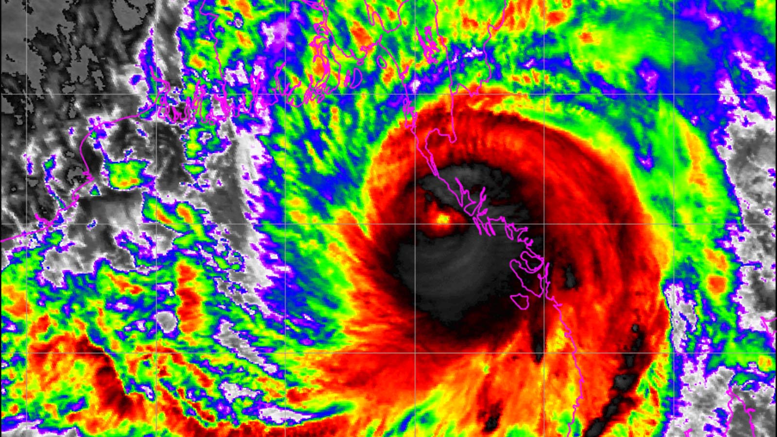
Unfortunately, Mocha lies at the upper end of the size spectrum for tropical cyclones, and severe impacts are being felt over an unusually large area. A satellite synthetic aperture radar wind profile at 23:57 UTC Saturday, near the time of peak intensity (Figure 1) found that Mocha’s Cat 4 winds (130 mph and greater) extended up to 25 miles from the center; hurricane-force winds extended out 90 miles; and tropical storm-force winds extended out 180 miles. A similar wind distribution was likely present at landfall (though somewhat reduced for the higher wind speeds).
Mocha will subject a huge area of Myanmar to damaging winds; the Myanmar Information Management Unit estimated that approximately 1.8 million people in Myanmar would be exposed to winds in excess of hurricane force. Another major threat is Mocha’s storm surge. The India Meteorological Department warned of a peak storm surge of 3.0-3.5 meters (9.8-11.5 feet) for the Myanmar coast near Sittwe. Mocha made landfall midway between low and high tide; tidal range between low and high tide is about 1 meter (3.3 feet). Thus, had the cyclone made landfall at high tide, its inundation would have been about 0.5 meters higher. Several videos from Sittwe, which endured the powerful right-front eyewall of Mocha (see Tweets below), showed a destructive storm surge inundating the city. Finally, according to recent runs of the HWRF model, Mocha is likely to dump widespread rains of 8-16 inches over portions of Myanmar, with isolated areas of 16-24 inches. These rains are likely to cause catastrophic flooding, particularly in low-lying coastal areas also experiencing storm surge.
One of the greatest concerns for high loss of life are the tens of thousands of Rohingya refugees housed in camps near Sittwe who received a direct hit from the cyclone. These camps mostly lie at elevations below 2 meters, and would have experienced a life-threatening storm surge. Camp residents are sealed off from the rest of the country by barbed wire fences with security checkpoints, and it is uncertain how Myanmar authorities handled storm preparations for these people.
Bangladesh missed the eyewall of Mocha, and was on the weaker left-front side of the storm. This gave the Bangladesh coast offshore winds below hurricane force, and very little storm surge, sparing the highly populous refugee camps the worst of Mocha’s impacts. Flooding from Mocha’s heavy rains will still be a concern in Bangladesh, though, and substantial wind damage was occurring for poorly-built structures (see Tweet below).

Already four Cat 5s globally in 2023
Mocha is Earth’s fourth Cat 5 storm of 2023, joining three Southern Hemisphere storms from earlier in the year: Cyclone Ilsa, which peaked with 160 mph of the coast of northwest Australia on Apr. 13; Cyclone Freddy, which peaked with 165 mph winds on Feb. 16 east of Madagascar, and Cyclone Kevin, which peaked with 160 mph winds on March 4 southeast of Vanuatu (after hitting the nation as a category 3 storm). This ties 2023 with 2003 and 2015 for the greatest number of Southern Hemisphere category 5 cyclones in a calendar year (with data from the Joint Typhoon Warning Center). A total of 36 Cat 5s have been recorded in the Southern Hemisphere with the earliest being in 1988. Reliable satellite data for the entire Southern Hemisphere was not available until 1997, and from 1997-2022, an average of 1.2 Cat 5s per year were recorded in the hemisphere. The 1990-2022 average globally for an entire calendar year is 5.3 Cat 5s, according to ratings by the National Hurricane Center and Joint Typhoon Warning Center.
Bob Henson contributed to this post.
Website visitors can comment on “Eye on the Storm” posts (see comments policy below). Sign up to receive notices of new postings here.
Source link