After slamming the U.S. territory of Guam on Wednesday as a Category 4 storm, Typhoon Mawar put on an impressive burst of rapid intensification, becoming a formidable Category 5 super typhoon with 175 mph sustained 1-minute average winds at 12Z Thursday, May 25. According to the Joint Typhoon Warning Center, this makes Mawar tied for third place as the strongest typhoon ever observed in May. Only Phyllis of 1958 (185 mph winds) and Damrey of 2000 (180 mph winds) were stronger May typhoons. Mawar is tied with Cyclone Mocha, which attained 175 mph winds on May 14 in the North Indian Ocean’s Bay of Bengal, as the strongest storm on Earth in 2023.
At 12Z Thursday, the Japan Meteorological Agency, the official agency responsible for typhoon warnings in the Northwest Pacific, estimated that Mawar’s central pressure was 910 MB, with 125 mph winds (10-minute average, which is normally substantially lower than the 1-minute average). This pressure makes Mawar tied as the third-strongest May typhoon in the Japan Meteorological Agency database behind Amy of 1971 (890 MB) and Iris of 1951 (909 MB).
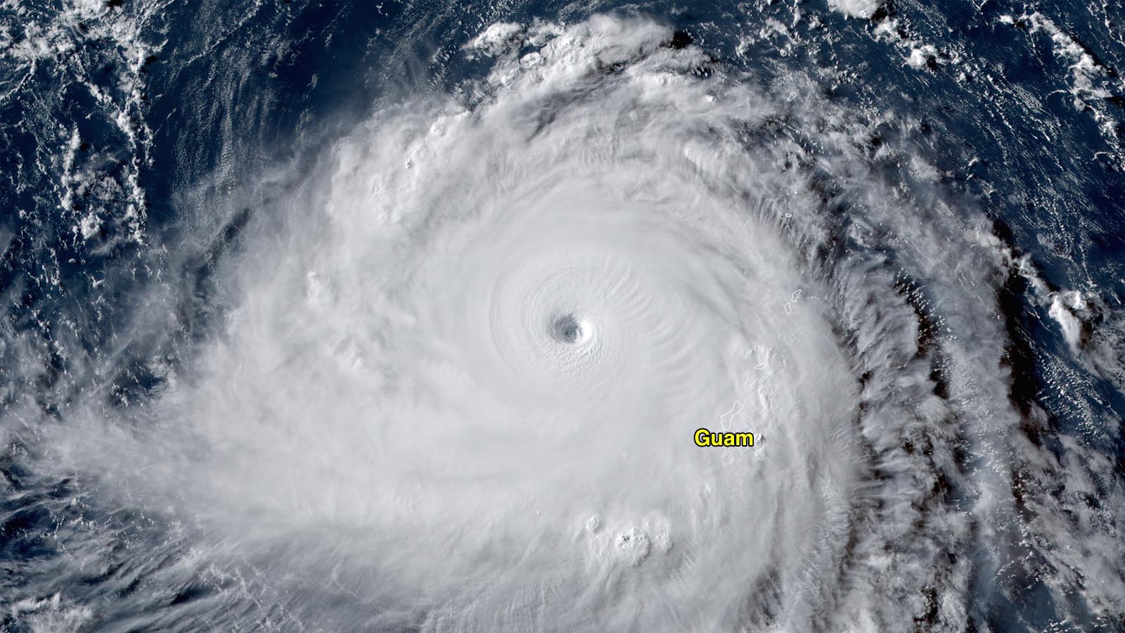
Guam caught a lucky break in the hours leading up to Mawar’s closest approach to Guam, when an eyewall replacement cycle caused the inner eyewall to collapse, weakening the typhoon’s peak winds from 155 mph to 130 mph. Even so, Mawar delivered a brutal pounding to Guam and Rota on Wednesday, as the storm’s center passed about 15 miles north of the northern tip of Guam. Guam’s Joint Information Center said no major injuries or deaths have been reported as of 3:30 a.m. EDT Thursday, but the extent of the damage on the island is still being ascertained. Over 98% of the island’s customers lost power during the storm.
Forecast for Mawar
Mawar recovered impressively from its eyewall replacement cycle on Wednesday, and satellite loops on Thursday morning showed a spectacular storm with a prominent eye surrounded by towering eyewall clouds with cold cloud tops. Mawar has favorable conditions for maintaining Category 5 strength through Saturday, with light wind shear of 5-10 knots and warm sea surface temperatures of 29-30 Celsius (84-86°F). Warm waters extend to great depth along Mawar’s track, giving it plenty of heat energy to draw upon. The Joint Typhoon Warning Center is predicting that Mawar will maintain category 5 strength with 160-175 mph winds through Saturday, and the Japan Meteorological Agency predicts that Mawar will maintain a 910 MB central pressure through Saturday.

Mawar is expected to track generally west-northwest for the remainder of the week, then turn to the northwest early next week. The Philippines’ Luzon Island, Taiwan, and Japan’s Ryukyu Islands all lay in Mawar’s five-day cone of uncertainty. Once the typhoon moves north of about 22 degrees north latitude (roughly parallel with Taiwan), the storm will encounter water temperatures below 26 degrees Celsius (79°F), which will cause weakening. Both the Joint Typhoon Warning Center and Japan Meteorological Agency predict significant weakening of Mawar beginning on Sunday.

Already five Cat 5s globally in 2023
Mawar is Earth’s fifth Category 5 storm of 2023, using ratings from the Joint Typhoon Warning Center. This is an unusually large number of these most violent of tropical cyclones for so early in the year. Only 2015 had more Cat 5s so early in the year: six by May 16. The 1990-2022 average globally for an entire calendar year is 5.3 Cat 5s, according to ratings by the National Hurricane Center and Joint Typhoon Warning Center. With the most active portion of the Northern Hemisphere tropical cyclone season yet to come, 2023 may have a chance of challenging the record of 12 Cat 5s in a year, set in 1997.
The other Cat 5s of 2023 include three Southern Hemisphere storms and a North Indian Ocean storm:
Cyclone Mocha peaked with 175 mph winds and a central pressure of 931 MB on May 14 in the Bay of Bengal, tying it as the strongest tropical cyclone on record in the North Indian Ocean. Mocha hit Myanmar as a category 4 storm with 155 mph winds, tying as the second-strongest cyclone at landfall in the North Indian Ocean in the Joint Typhoon Warning Center database. Mocha’s toll is uncertain, because of information restrictions imposed by the military government of Myanmar, but it appears likely that hundreds died in Myanmar’s Rohingya camps.
Cyclone Ilsa peaked with 160 mph winds and a central pressure of 925 MB off the coast of northwest Australia on Apr. 13. Ilsa killed eight and caused $8 million in damage to Australia.
Cyclone Freddy peaked with 165 mph winds and a central pressure of 918 MB on Feb. 16 east of Madagascar. Freddy made three landfalls—one in Madagascar and two in Mozambique. The storm is being blamed for at least 1,424 deaths, mostly in Malawi. This makes Freddy the deadliest tropical cyclone on record for Africa, and second deadliest in the Southern Hemisphere.
Cyclone Kevin peaked with 160 mph winds and a central pressure of 915 MB on March 4 southeast of Vanuatu (after hitting the nation as a category 3 storm). The storm is being blamed for $50 million in damage, but no deaths.
Bob Henson contributed to this post.
Website visitors can comment on “Eye on the Storm” posts (see comments policy below). Sign up to receive notices of new postings here.
Source link