Hurricane Roslyn exploded into a category 4 storm with 130 mph winds Saturday morning, putting on an impressive feat of rapid intensification rarely seen in the eastern Pacific. Roslyn is expected to take a looping track that would bring it onshore just north of Puerto Vallarta on Sunday morning.
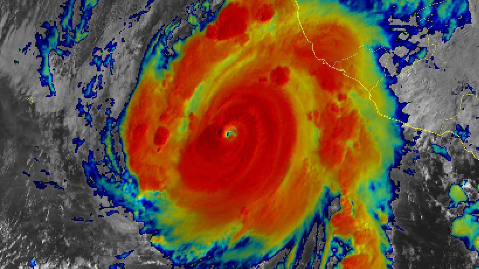
As of 11 a.m. EDT Saturday, Roslyn’s top winds were 130 mph, with a central pressure of 950 mb. The storm was about 150 miles west-southwest of Manzanillo, Mexico, heading north-northwest at 8 mph. A hurricane hunter flight was beginning to investigate Roslyn early Saturday afternoon. Satellite images on Saturday afternoon showed it to be a small hurricane with a prominent eye and several prominent spiral bands, one of which was bringing heavy rain to the coast of Mexico.


Roslyn intensified by 65 mph in the 24 hours ending at 11 a.m. EDT Saturday. According to meteorologist Michael Lowry, only about 0.6% of all tropical or subtropical cyclone “fixes” (6-hourly storm intensity estimates) in the eastern Pacific have exhibited such rapid intensification. Hurricanes Orlene and Darby earlier this year had similar levels of rapid intensification, as did Hurricane Kiko in September of 2019.
Rosyln’s ascent to a major hurricane brings the tally of tropical cyclone activity in the eastern Pacific to 17 named storm, 10 hurricanes, 4 intense hurricanes, and an accumulated cyclone energy (ACE) index that is 87% of average for the date. The 1991 – 2020 averages for this time of the season are 15.7 named storms, 8.5 hurricanes, and 4.5 major hurricanes, so 2022 can be regarded as a near-average season for activity.
Forecast for Roslyn
Roslyn has somewhat marginal conditions for further intensification. Although sea surface temperatures (SSTs) are a warm 29 degrees Celsius (84 degrees Fahrenheit), wind shear is expected to rise from a moderate 10 knots Saturday morning to a high 20 knots by Sunday morning. A somewhat dry atmosphere with a mid-level relative humidity of around 55% will also not aid development, and interaction with land can be expected to weaken Rosyln beginning on Saturday night. Rosyln is a small hurricane, which makes it more prone to rapid changes in intensity, either upward or downward.
The SHIPS rapid intensification index issued at 8 a.m. EDT Saturday gave a 19% chance of Roslyn’s sustained winds increasing to category 5 strength, 160 mph, by 8 a.m. Saturday, and the newer DTOPS index gave 0% odds. The National Hurricane Center predicts Roslyn will peak as a category 4 hurricane with 140 mph winds Saturday night, then weaken to a category 3 hurricane with 120 mph winds before landfall on Sunday morning.
The hurricane’s center likely will pass near the coast just west of Puerto Vallarta on Saturday night, putting the city on its stronger right-hand side, before arcing north and making landfall on Sunday morning farther to the north, between Puerto Vallarta and Mazatlan. In its 11 a.m. EDT Saturday wind probability forecast, NHC gave Puerto Vallarta an 87% chance of experiencing tropical storm-force winds, and a 15% chance of hurricane-force winds. Mazatlan’s odds were 41% and 2%, respectively.
Roslyn will be speeding up to a forward speed of about 15 mph near the time of landfall, which will limit the amount of rain the storm will drop. NHC predicts a much lower rainfall total than usual for a Mexican hurricane: peak amounts of 4 – 8 inches, with isolated areas of up 10 inches. But wind and storm surge damage will be high where Roslyn’s core makes landfall.
Roslyn is following a track similar to that of Hurricane Orlene, which also intensified to a category 4 storm with 130 mph winds in a similar location back on October 2. Orlene rapidly weakened before making landfall as a category 1 hurricane with 85 mph winds on October 3, in a location similar to where Roslyn is expected to hit. Orlene knocked out power to 53,000 customers and caused moderate damage in Mexico, but no deaths were reported from the storm. The strongest hurricane to make landfall between Puerto Vallarta and Mazatlan in reliable records was Kenna, a category 4 storm that struck near San Blas in late October 2002. Kenna took four lives and inflicted more than $100 million in damage (USD 2002).
After Roslyn quickly dissipates over the rugged terrain of western Mexico, its moisture will be pulled into the south-central United States ahead of a sharp upper-level storm system – perhaps contributing to welcome rainfall early next week across drought-stricken landscapes from Texas to Missouri.
Bay of Bengal tropical depression forms
In the North Indian Ocean, a tropical depression has formed in the Bay of Bengal, according to the India Meteorology Department. The Joint Typhoon Warning Center has not yet recognized the system as a tropical depression, and refers to it as Invest 92B. The depression is expected to develop into a tropical storm by Sunday and track toward Bangladesh. The depression has favorable conditions for development, with sea surface temperatures (SSTs) of 29 – 30 degrees Celsius (84 – 86°F), light to moderate wind shear of 5 – 15 knots, and a moist atmosphere. These SSTs are 1 degree Celsius (1.8°F) above average. Satellite images on Saturday showed that 92B with a modest-sized area of heavy thunderstorms steadily growing more organized.
Steering currents favor a northwesterly track for 92B through Sunday morning, and then a sharp turn to the north-northeast, thanks to the steering influence of a trough of low pressure passing to the north. Landfall is expected in Bangladesh on Monday. The landfall intensity of 92B will depend on how long the storm is over water; a faster forward speed and an earlier landfall would likely not give 92B enough time to intensify into a category 1-strength cyclone. Most of the models have shifted to a faster forward speed and earlier landfall in Bangladesh on Monday, showing the system making landfall as a tropical storm. In their 6 a.m. EDT Saturday advisory, the India Meteorology Department predicted that 92B would peak as a category 1-equivalent cyclone at 18Z on Monday, shortly before landfall in Bangladesh. The next name on the Indian Ocean list of storms is Sitrang.


Disturbance 94L in the Atlantic no threat to land
An area of disturbed weather, designated Invest 94L by NHC, is spinning in the waters of the central subtropical Atlantic several hundred miles east of Bermuda. The system has marginal conditions for development, and is not a threat to any land areas, as it heads west to west-northwest at 15-20 mph. By Wednesday, wind shear is expected to rise to a very high 30-40 knots, likely ending any chance for further development. In its 8 a.m. EDT Saturday Tropical Weather Outlook, NHC gave 94L 2-day and 5-day odds of development of 10% and 20%, respectively.
High wind shear rules in the tropical Atlantic, and high wind shear is predicted to dominate for the next five days, making tropical cyclone formation there difficult. By the end of October, the GFS model suggests, wind shear may decrease over the southern Caribbean, allowing greater chances for tropical cyclone formation there. SSTs in the Caribbean are running up to 0.5 degree Celsius (0.9°F) above average, which would aid the development of any storms that manage to organize.
Invest 93W in the western Pacific a potential threat to the Philippines
An area of disturbed weather, designated 93W, in the western Pacific near the Mariana Islands, was headed west toward the Philippines with the potential to organize into a tropical storm by Wednesday, as predicted by the Saturday morning runs of the GFS and European models. This system has long-range potential to become a typhoon, and residents of the Philippines should watch this system.
Bob Henson contributed to this post.
Website visitors can comment on “Eye on the Storm” posts (see comments policy below). Sign up to receive notices of new postings here.
Source link