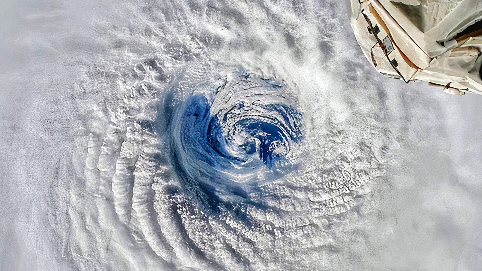
Tropical Cyclone Freddy made landfall on the central east coast of the island nation of Madagascar at approximately noon EST (16Z) or 8 p.m. local time Tuesday, Feb. 21, as a weakening category 3 storm with 115 mph winds, according to the final advisory before landfall from the Joint Typhoon Warning Center. The coast near the landfall location is moderately populated, and damage from storm surge and wind is likely to be extensive. However, the biggest concern from Freddy will be its widespread rains of 4-8 inches, which are expected to affect the nation’s third-largest city, Antsirabe (population 250,000).
Dangerous flooding is likely because soils along Freddy’s expected path are already saturated from flooding rains brought by January’s Tropical Cyclone Chenesco. Chensco stalled off the west coast of the island and brought torrential rains Jan. 19-21 that killed 33 people, left 20 missing, and made 34,000 people homeless. In addition, the flood damage potential for Freddy is higher than for storms in previous decades, because of the considerable deforestation Madagascar has experienced over the past 20 years: Madagascar lost 24% of its forest cover between 2000 and 2020, according to globalforestwatch.org. Madagascar is quite mountainous, so the deforestation allows floodwaters to build up to higher heights, run off more quickly, and cause greater damage.


After Madagascar, a second landfall in Mozambique
The Joint Typhoon Warning Center predicts that Freddy will weaken to a tropical storm while crossing Madagascar, then emerge over the Mozambique Channel on Wednesday. Conditions between Madagascar and Mozambique favor intensification, and Freddy will likely be approaching hurricane strength before making landfall in southern Mozambique early Friday morning (U.S. EST). After landfall in Mozambique, Freddy is predicted to stall and potentially bring extremely dangerous heavy rains in excess of 10 inches to southern Mozambique and northeastern South Africa.


Freddy the all-time Southern Hemisphere ACE record-holder
Freddy is an unusually long-lived and powerful tropical cyclone for the Indian Ocean. Freddy was named Feb. 7 off the coast of northwestern Australia and has already generated about 66 units of accumulated cyclone energy, or ACE, a measure of cyclone strength over time, according to Dr. Phil Klotzbach of Colorado State. This breaks the previous Southern Hemisphere single-storm record for ACE of 53 formerly held by Cyclone Fantala of 2016. Only two Atlantic hurricanes have had a higher lifetime ACE index than Freddy: Hurricane Three of 1899 (ACE of 73.6) and Hurricane Ivan of 2004 (ACE of 70.4). The highest ACE for a single tropical cyclone globally is 82, for Hurricane/Typhoon Ioke in 2006. Freddy will not break this record; the current Joint Typhoon Warning Center forecast calls for Freddy to gain another 3-4 ACE units before its demise, giving it a lifetime ACE near 70.
Freddy also did something no other Southern Hemisphere tropical cyclone has done: undergo four separate rounds of rapid intensification (see Tweet below). This behavior occurred because of repeated bursts of wind shear that weakened Freddy, and then abated.
Freddy is the second unusually powerful and long-lasting tropical cyclone in the South Indian Ocean in the 2022-23 season; Tropical Cyclone Darian, which peaked just below category 5 strength on Dec. 23 with 155 mph winds, generated 42.5 units of ACE for its lifetime. According to Colorado State, the South Indian Ocean is now 75% above average for ACE for the 2022-23 season.
Madagascar tropical cyclone history
Major tropical cyclones have hit Madagascar an average of about once every three years since accurate satellite data began in 1997; there were nine such landfalls from 1997-2022. The strongest and deadliest tropical cyclone to hit the island in the satellite era was Tropical Cyclone Gafilo, which hit the northern end of Madagascar on March 7, 2004 as a category 4 storm with 150 mph winds. Gafilo dumped up to 20 inches of rain, and its winds and flooding rains killed 363 people and did $375 million in damage (2022 USD), making it the fourth-most expensive storm in Madagascar’s history. Before making landfall, Gafilo’s central pressure of 895 mb was the lowest of any tropical cyclone ever recorded in the South Indian Ocean.


Six other category 4 storms have hit the island:
Cyclone Enawo, March 7, 2017, 150 mph winds;
Cyclone Givanna, Feb. 13, 2012, 130 mph winds;
Cyclone Hudah, April 2, 2000, 130 mph winds;
Cyclone Gretelle, Jan. 24, 1997, 130 mph winds;
Cyclone Bonita, Jan. 10, 1996, 130 mph winds; and
Cyclone Geralda, Feb. 2, 1994, 130 mph winds.
In addition, a March 1927 cyclone that killed as many as 500 people may have been a Cat 4.
Madagascar’s most expensive tropical cyclone was Tropical Cyclone Emilie, which made landfall on the island’s east coast on Feb. 2, 1977 as a minimal tropical storm with 40 mph winds. Emilie dumped torrential rains that caused $1.7 billion in damage (2022 USD).
The last major cyclone to hit Madagascar was Cyclone Batsirai, which made landfall on Madagascar’s east coast on Feb. 5, 2022 as a category 3 storm with 115 mph winds, according to the Joint Typhoon Warning Center. Batsirai killed 121 people and did $190 million in damage; over eight inches of rain fell near the landfall region. Freddy is predicted to make landfall very close to where Batsirai did, and similar impacts are possible. Batsirai was one of four tropical cyclones to affect Madagascar in the space of 40 days between late January and early March 2022, along with Ana, Dumako, and Emnati.
More tropical cyclones have been affecting Madagascar in recent years (red areas on map in Figure 3); this trend is not yet statistically significant (where white dots are). It is unknown to what degree natural variability versus climate change is responsible for this change.


Climate change not the main driver of Madagascar’s devastating drought
Southern Madagascar has endured a grave food security crisis since 2018 brought about by drought, with the rainy seasons of both 2019-20 and 2020-21 bringing just 60% of normal rainfall. The lack of rain over the 24 months from July 2019 to June 2021 was estimated as a 1-in-135-year dry event, surpassed in severity only by the devastating drought of 1990-92. The 2018-2022 drought put over 1.6 million people at high levels of acute food insecurity in 2022; that number has since fallen to 1.35 million people, thanks to an improvement in drought conditions in recent months.
Climate scientists authoring a December 2021 study with the World Weather Attribution group, “Factors other than climate change are the main drivers of recent food insecurity in Southern Madagascar,” found that “occurrence of poor rains as observed from July 2019 to June 2021 in Southern Madagascar has not significantly increased due to human-caused climate change.”
Even where precipitation has not changed, human-caused global warming has been found to make drought more intense in many parts of the world by increasing evaporation and drying out vegetation. However, the authors believe this is not the case for Madagascar. They cited researchers who found in 2021 that in arid and semiarid regions in East Africa, climate change-induced increases in temperature do not appear to cause significant increases in the likelihood of witnessing exceptional soil moisture deficits (and thus more intense droughts that dry out vegetation and hurt crops).
However, drought expert Chris Funk, director of the Climate Hazards Center at the University of California, Santa Barbara, disagreed with this assessment. In an interview with insideclimatenews.com, Funk asserted “the truth is in the middle” and added: “As a climate scientist I would never say climate change is 100% responsible. But the weather attribution group did a very quick rapid attribution study — and I think, incorrectly —concluded that there is no climate change influence.”
The World Weather Attribution authors also summarized recent climate modeling research, which suggests that “future warming over the twenty-first century could lead to small-to-moderate increases in wet-season rainfall over southern Madagascar, while the latter half of the dry season (August-October) is projected to become drier and longer.”
South Indian Ocean tropical cyclone history
Over the long-term average, the South Indian Ocean racks up about two-thirds of the total accumulated cyclone energy for the entire Southern Hemisphere and about 15-20% of the global total.
NOAA’s hurricane history database lists 18 tropical cyclones in the South Indian Ocean that have achieved category 5 strength since 1989 (19 if Freddy is included). Since accurate satellite record keeping began in 1997, 15 category 5 storms have occurred in the South Indian Ocean—an average of approximately one Cat 5 every two years.
The strongest of these storms, Tropical Cyclone Fantala in 2016, peaked with maximum sustained winds of 180 mph and a central pressure of 907 mb pressure. Fantala did not make landfall, though its eyewall did affect the Farquhar Atoll while the storm was at category 5 strength. Fantala is also the all-time intensity record holder for the entire Indian Ocean, since it tops the record holder for the North Indian Ocean, Tropical Cyclone Fani of May 2019 (peak 1-minute winds of 175 mph). Note, though, that some consider Tropical Cyclone Monica of 2006 (180 mph winds) tied as the strongest Indian Ocean Basin storm on record. Definitions vary on the boundary of the Indian Ocean, though, and Monica reached peak strength north of Australia in the Arafura Sea, which is considered by several sources, including the CIA World Factbook, to be part of the western Pacific Ocean, not the Indian Ocean.
No South Indian Ocean tropical cyclone has ever been recorded to make landfall at category 5 strength. At least 17 have made landfall at category 4 strength: two in Mozambique, seven in Madagascar, and eight in western Australia.
Prior to Freddy, the most recent Cat 5 in the basin was Faraji (160 mph winds, 925 mb central pressure) on Feb. 8, 2021.
Bob Henson contributed to this post.
Website visitors can comment on “Eye on the Storm” posts (see comments policy below). Sign up to receive notices of new postings here.
Source link