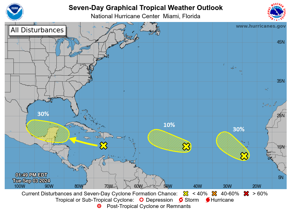
Headlines
- A tropical wave in the Caribbean maintains about a 30 percent chance to develop in the coming days.
- Model guidance doesn’t quite eliminate that wave as a potential area to monitor for the Bay of Campeche and/or Gulf, but very few models are bullish on intensity right now.
- The rest of the Atlantic is rather quiet for September.
- A potentially historic rain event in the Sahel and Sahara Desert may be symptomatic of bigger issues at play that could partially explain some of this season’s failure to launch.
Caribbean wave continues to lurk
The number of forecast consensus iterations on this Caribbean tropical wave over the last week or so have been rather annoying. Initially, we were discussing a system possibly heading out to sea. Then we started to discuss development farther west in the Caribbean followed by either a turn north or a continued track west. Then, even yesterday it looked like this was doomed to fail completely. And now today we have a new possible forecast wrinkle. In some ways, that’s “chasing” models, a practice that is not enjoyable, nor especially recommended. In other ways, I’m not sure what else you’re supposed to do with a struggling tropical wave that refuses to organize. It’s “guidance” for a reason, and in this case, the guidance has been shifting about.
Anyway, end rant. here’s the Caribbean wave on satellite this afternoon.

I mean, that’s a respectable amount of thunderstorm activity. But there’s no organization to things here. At least not yet. That could change in the coming days but probably not before Friday. Admittedly, this system is a bit confounding in that it’s generally in a healthy environment to organize but thus far it is not doing so. It could be sinking air in the background suppressing things, it could the 20 to 25 mph forward speed of the system, or it could be proximity to Hispaniola that is currently holding it back. As this reaches the western Caribbean, it may have a slightly better opportunity to organize, albeit slowly. Expect this to be positioned off the east coast of the Yucatan or near Belize by Thursday night.
From there, we will embark on a choose your own adventure scenario with this. A trough over the Eastern U.S. will attempt to pull this system north — if the system can gain enough strength to do so. That seems unlikely at this time. Steering currents will sort of collapse as that trough pulls away, leaving the system in the Bay of Campeche or nearby just sort of wandering aimlessly.
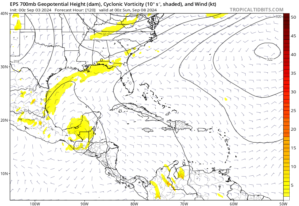
You can see that above with last night’s European ensemble modeling. The mean of the 51 ensemble members shows a good signal for some sort of disturbance in the Bay of Campeche by Sunday but then a gradual dissolution of the signal by next Thursday. This suggests that the system will meander in or around the Bay of Campeche, maybe even onshore in Mexico next week. From there, as the steering currents collapse, we could see some northward drift to the system, particularly if it begins to organize. So no one should be entirely ruling this out. But at this point, there are mostly a bunch of hypotheticals and no clear signal on potential track or impacts, except to say that most guidance is generally lower-end with this one, the exception being the ICON model and some AI modeling.
In fact, as of the latest NHC tropical weather outlook, development odds with this have dropped to 30 percent.

The Atlantic remains calm, mostly
There are two other areas noted on the NHC outlook above. Neither one should impact land over the coming days. The trailing wave closest to Africa may have the better chance to develop, though admittedly the leading wave looks a little healthier at the moment.
Bless the rains (up?) in Africa
But there are weird things happening right now, and we’ll certainly get into them in the days ahead. For one, tropical waves may again emerge too far north off Africa to really produce much in the way of development. In fact, if you look at the forecast rainfall as a percent of normal in Africa over the next 2 weeks, it very clearly shows that portions of the Sahel and even the Sahara Desert are expected to get more than their fair share of rainfall.
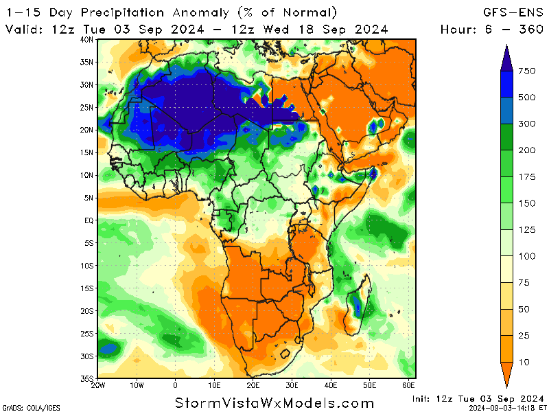
This is truly odd. And possibly historic. Now, the amount of rain that can produce 500 to 750 percent of normal rainfall in those areas is probably a lot less than you’d expect. When your average precipitation totals are miniscule, well it doesn’t take much. But still, it’s impressive. There was a decent write-up about this from a site over in Europe that I think touches on some of what’s happening here, key among it: The inter-tropical convergence zone (ITCZ) is displaced just enough farther north than normal to have a strong impact on what we see in the Atlantic. Everything is connected in some way, and it’s plausible that such an outlier event is in some way related to the extreme, historic warmth of the Atlantic Ocean right now. I don’t want to overshoot my skis here, as this is not a topic I’m overly familiar with. But it will merit research and further analysis.
Some of the seeds of that research have been done already, with a recent paper led by author Dr. Kelly Nuñez Ocasio from Texas A&M. Their work suggests that more moisture in the atmosphere as both the oceans and atmosphere warm with climate change can lead to a shift in tropical wave coupling with thunderstorms. In other words, you would get something like we see now, with more waves and storms to the north, and less robust waves emerging off Africa in the places we expect to see them in September. It’s a fascinating study, and given that the paper was published in June, it could not be more timely.
Is this what we’re seeing? Maybe. There’s a theory that supports it, but you obviously can’t prove anything based on one event in one season. But given that we’re probably about to hear a whole lot of people screaming “bust” at the top of their lungs with respect to this hurricane season, it makes for a provocative possible explanation, among other things we’ve touched on.
Source link