New Zealand’s largest city, Auckland — renowned for its typically tranquil climate — is now gasping its way through a flood-soaked southern summer that won’t quit. Having endured its wettest month and wettest single day on record, Auckland is now looking warily to its northwest as Tropical Cyclone Gabrielle gathers steam. Gabrielle is likely to bring yet another punishing round of heavy rain to New Zealand’s North Island early next week.
Climate change is exacerbating the wet setup, as a freight train of rainmaking systems from the tropical western Pacific draws on unusually high sea surface temperatures (up to six degrees Celsius or 11 degrees Fahrenheit above average near the South Island) associated with a marine heat wave. Intensified short-term rains and warming oceans are two of the most clearly established effects of a human-warmed planet.
Read: Why is it raining so hard? Global warming is delivering heavier downpours
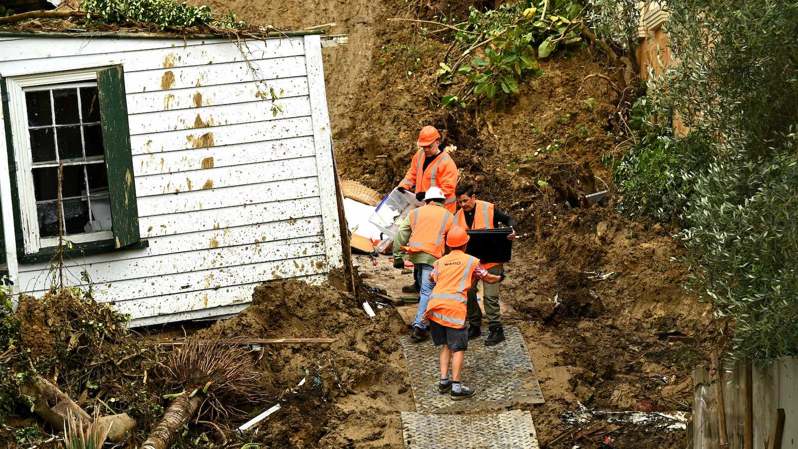
Auckland had already racked up one of its wettest months in 170 years of record-keeping before an especially intense round of rain on Jan. 28 triggered particularly severe flooding. The month’s final total of 539 millimeters (21.22 inches) was more than 25% higher than any other month going back to 1853, including the old record of 420 mm (16.54 inches) set in February 1869, according to NIWA, New Zealand’s National Institute of Water and Atmospheric Research/Taihoro Nukarangi.
Insured damage for New Zealand’s resulting January floods could hit $630 million USD, according to one estimate, which would make it the nation’s costliest flood on record by far. At least four deaths have been reported. According to EM-DAT, the international disaster database, New Zealand’s previous costliest flood was a summer 2004 flash flood that cost $310 million (2023 USD).
New Zealand’s only billion-dollar weather disaster on record (adjusted for inflation) was a 2013 drought that cost $1.1 billion.


The band of culprits putting Auckland underwater
La Niña, the cooling of the eastern Pacific that’s been in control since late 2020 and is expected to wrap up early this year, tends to generate warming in the western Pacific. It often leads to tropical cyclones rolling their way from the Coral Sea southeast toward New Zealand. However, most such cyclones angle away from the island nation or weaken before reaching it.
This summer in the southwest Pacific, La Niña has had unusually juicy air to work with. One analysis from NOAA and the University of Wisconsin, Madison, found that precipitable water (the amount of moisture in a column above the surface) was running up to twice its usual values for the region within an atmospheric river in late January.
The atmospheric river was funneled toward New Zealand by a tropical low (the remnants of Tropical Cyclone 10P), and the moisture was squeezed out across the North Island, particularly the Auckland area.
“Converging moisture with origins from the tropics almost always produces extreme precipitation downstream,” tweeted Sheldon Kusselson, a retired satellite meteorologist from NOAA.


On Jan. 28, Auckland’s Albert Park reported an unprecedented 280 mm of rain (11.02 inches), including 211 mm (8.31 inches) in just six hours.
“The Earth has warmed by about 1.1°C already because of human activity and this extra heat gives more power to extreme rainfall. All other things being equal, we would expect climate change to contribute between 10-20% more rain in the most intense part of this storm,” said climate scientist Sam Dean in a NIWA media release.
Another factor: water infrastructure that hasn’t kept up with a growing city. “Many parts of the network are aging and under increasing pressure from continued urbanization and greater rainfall intensity,” said NIWA urban aquatic scientist Annette Semadeni-Davies in the media release.
“Nature-based solutions, such as infiltration basins, ponds, and wetlands, have been put forward as additions to our current pipe-based systems for flood protection. However, these alone won’t be enough. We also need to explore low-risk infrastructure that diverts and stores water more effectively, introduce managed retreat for vulnerable areas, and continued maintenance and upgrades to our existing drain network.”
Kevin Trenberth, a senior scientist emeritus and expert on global water and climate change long based at the U.S. National Center for Atmospheric Research, is now living in his native New Zealand near Auckland.
“Recently, as part of a team of international scientists that just published a paper on ocean changes, I’ve been commenting on the fact that the [global] oceans are at their warmest state ever and that it has consequences,” Trenberth wrote in an essay on Jan. 29.
“While the recent flood disasters are not directly caused by climate change, the warming climate contributes substantially to making all extremes more so, and the damage increases exponentially.”
Gabrielle gathers strength en route to New Zealand
Tropical Cyclone Gabrielle will add to the woes of northern New Zealand over the next few days. Because it originated from a large monsoonal low, Gabrielle has been slow to organize. The flip side is that Gabrielle is an unusually large tropical cyclone already packing immense amounts of water vapor. Gabrielle’s sustained winds as of 7 a.m. EST Thursday were 80 mph.
Gabrielle is predicted to head on a straightforward southeast track over the next several days, peaking as a high-end category 1 hurricane with 90 mph winds on Friday morning (U.S. EST). By late in the weekend, Gabrielle should hook southward just as it nears the North Island, likely going through post-tropical transition around this time, and Gabrielle may be subtropical or extratropical when it makes its closest approach to New Zealand. Tropical cyclones are uncommon in New Zealand; NOAA’s historical hurricane database shows only two hurricane-force storms have ever hit the island, Tropical Cyclone Gisele (1968) and Tropical Cyclone Alison (1975).
Regardless of how the storm is classified, the predicted motion would allow Gabrielle’s clockwise circulation to fling a large field of deep tropical moisture across the North Island. Ensemble output from the GFS model (GEFS) indicates that the Auckland area could easily pick up four inches or more of rainfall on Sunday and Monday, with even heavier amounts possible across east-facing slopes. Falling on saturated soils, the heavy rain could lead to serious flooding. High winds from Gabrielle could bring down trees and power lines.
Because of Gabrielle’s large area of tropical-storm-force winds, coastal damage from several feet of storm surge is also a danger.


Australia has seen a decrease in tropical cyclones in recent years
Even as New Zealand will have suffered through the impacts of two tropical cyclones this year, Australia — which is historically more prone than New Zealand to catastrophic impacts from tropical cyclones — has enjoyed yet another relatively tranquil cyclone season thus far.
Natural variability and climate change have caused significant changes in the distribution of tropical cyclones in recent decades, and Australia has been the beneficiary of a reduced incidence of landfalling tropical cyclones (Figure 3).
According to statistics from EM-DAT, Australia has suffered seven billion-dollar tropical cyclones since 1974. Just one of these storms, Tropical Cyclone Debbie of 2017, occurred in the past 10 years. However, some islands of the Southeast Pacific to the east of Australia, such as Tonga and Samoa, have seen an increase in tropical cyclones.
Website visitors can comment on “Eye on the Storm” posts (see comments policy below). Sign up to receive notices of new postings here.
Source link