Dozens of lives were lost in Mississippi on Friday night, March 24, from a compact, fast-evolving tornado outbreak that struck a highly vulnerable area after dark. The bulk of death and destruction resulted from a single supercell thunderstorm that plowed across the breadth of northern Mississippi and Alabama with one or more long-track tornadoes.
More severe weather is possible across the South on both Saturday and Sunday, March 24-25, although the conditions will not be as favorable for intense tornadoes on these days as they were on Friday.
Friday’s outbreak was well predicted by the NOAA/NWS Storm Prediction Center, or SPC (see our March 24 post), and tornado warnings were issued along the path of the prolonged supercell. However, the main supercell’s rapid motion (more than 50 mph) and its after-dark timing amplified the danger.
The hardest-hit places in Mississippi included Amory, Winona, and particularly Rolling Fork, a town of about 1,900 people that was largely destroyed.
Manufactured homes, which are especially vulnerable in tornadoes, appear to have been hard hit in the outbreak. As of 2021, such structures in Mississippi made up nearly 60% of all new single-family homes, the largest percentage for any U.S. state. Many of these homes sit in clusters—and in rural areas, on small acreages—that may lack nearby shelter access.
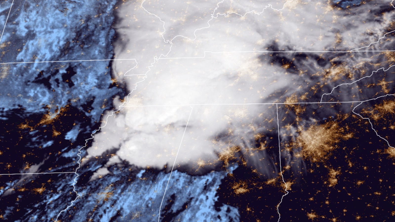
Friday’s outbreak was the nation’s deadliest since the out-of-season tornado catastrophe that took close to 90 lives in and around western Kentucky on December 10, 2021, including the city of Mayfield. At several points last night, the Mississippi/Alabama supercell and its tornadic fingerprints bore more than a passing resemblance to the Mayfield storm on radar (see Tweet below), including the classic, wrapping “hook echo” in the precipitation images (top row) and the tight wind couplet in the velocity images (bottom row).
Friday night’s destructive supercell was born in northeast Louisiana and appears to have become tornadic near the LA/MS state line, as detailed in this radar analysis. Tornado reports from the storm extended to far northern Alabama.
How strong were the tornadoes?
Survey teams organized by the National Weather Service offices in Jackson, MS; Huntsville, AL; and Memphis, TN, will scour the extensive damage over the next several days, hunting for clues to the strength of Friday night’s twisters and working to distinguish individual tornadoes. It appears this was a tornado family—a series of multiple twisters developing along a single path, with only short breaks in between—and one or more of these tornadoes may have been especially long-lived.
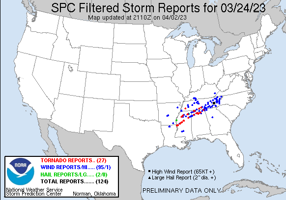
Of the 12 preliminary tornado reports archived by SPC as of Saturday afternoon, nearly all were along the line traversed by the supercell. That total of 12 may decrease to the extent that storm surveyors end up linking multiple tornado reports to a single long-lived twister.
The storm’s intense signature on radar and the widespread destruction made it clear that the main supercell packed at least one tornado that will almost certainly lie on the higher end of the Enhanced Fujita Scale. However, when you hear specific EF ratings proclaimed immediately after a tornado (or even during it), it’s crucial to keep in mind that the EF scale is literally a damage scale. It’s based on careful analysis of storm wreckage conducted by experts rather than on radar returns, initial photos, or any other second-hand evidence (though scientists and engineers are considering broadening how EF ratings are determined as part of a multiyear process now under way).
A weakly constructed building, such as a manufactured home, can be demolished in winds that would only partially damage a sturdier structure. For this very reason, one can’t use a totally leveled home—or even a whole neighborhood of them—as firm evidence that a tornado has earned the top rating of EF5. To come up with an official EF rating, surveyors use a total of 28 damage indicators, each with a range of potential impact, that take into account building type and construction techniques. Sarah Dillingham, formerly a broadcast meteorologist at The Weather Channel and now senior director for product design at the Insurance Institute for Building and Home Safety, stressed this point on Twitter.
The Friday night tornadoes passed within 20 miles of several radars and other mobile equipment deployed as part of the NOAA-based PERiLS experiment (Propagation, Evolution, and Rotation in Linear Storms).
PERiLS is designed specifically to study tornado environments such as quasi-linear convective systems (squall lines), where tornado formation is distinct from the long-lived supercell mode in play on Friday night. Even so, data from the dense instrumentation of PERiLS will surely shed light on Friday’s horrific events.
Jeff Masters contributed to this post.
Website visitors can comment on “Eye on the Storm” posts. Comments are generally open for 30 days from date posted. Sign up to receive email announcements of new postings here. Twitter: @DrJeffMasters and @bhensonweather
Source link