What had been pegged as an evening with a slim but serious chance of tornadoes erupted on Wednesday, April 19, in a bizarre dance of storms and twisters that played out for hours across central Oklahoma.
The most intense tornadoes of the day may be the ones that struck the tiny town of Cole (pop. 600) just southwest of Norman, killing at least two people, and Shawnee (pop. 31,000), east of Oklahoma City, where major damage extended to the high school, a shopping mall, and Oklahoma Baptist University. Storm surveys were ongoing Thursday morning.
Other storms developed along a dry line and cold front from northern Texas to Iowa and eastward to Wisconsin and Illinois near and south of a warm front. Preliminary data from the NOAA/NWS Storm Prediction Center showed at least 15 tornado reports and more than 150 reports of large hail by early Thursday.
An Oklahoma Mesonet weather station in Shawnee captured a wind gust to 84 mph at 10 p.m. EDT, just as a tornado moved nearby.
Storm Prediction Center forecasters had called for only a slight risk of severe weather across most of the affected region, given a strong cap that was expected to keep a lid on thunderstorm activity until evening. But by late morning Wednesday, the center had flagged southern parts of the frontal zone in Oklahoma and Texas with a “conditional strong tornado threat after dusk” — meaning that severe storms might not form at all, but if they did, strong late-day tornadoes would be possible.
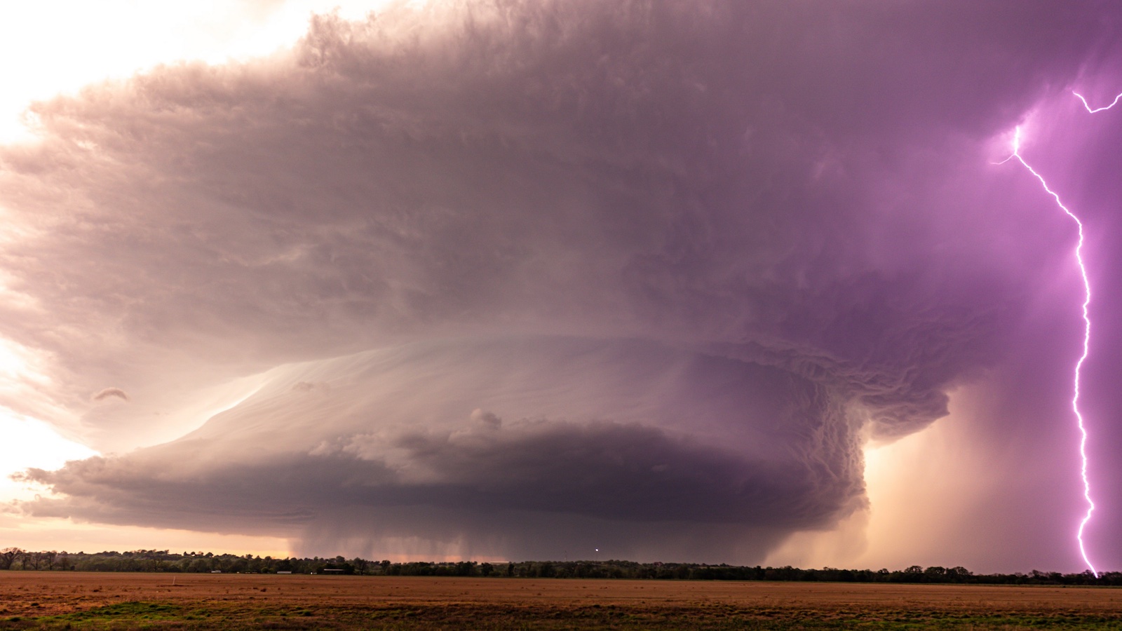
The relatively modest amount of low-level moisture meant that Friday’s pre-dusk storms were highly visible, allowing storm chasers and other weather aficionados across the Plains to gather spectacular imagery.
Just as compelling, at least for weather-data geeks, were the radar returns (see below), especially for the complex cluster of storms that moved slowly from just south to just east of the Oklahoma City area. Winds in the lowest few miles of the atmosphere were fairly light (less than 30 mph) but veered dramatically with height — an ideal setup for storms that were slow-moving but strongly rotating.
While the storm complex gradually moved east-northeast, individual cells and areas of rotation moved in wildly divergent directions, some heading northwest and west for a time, or even spinning around each other in a dance similar to the Fujiwhara effect seen in tropical cyclones that approach each other.
Here’s the entire Cole, OK tornado sequence on radar. Super cool. pic.twitter.com/CrOoJXQcQM
— Jim Tang (@wxmann) April 20, 2023
Freakish as they were, the central Oklahoma storms do bring to mind a roughly similar event that was far more devastating. On June 3, 1980, a storm complex crawled across Grand Island, Nebraska, over more than two hours, producing four tornadoes of at least F3 strength and leading to five deaths and about 200 injuries. It also spawned a 1984 young-adult novel and a 1996 film, both entitled “Night of the Twisters.” The Hastings, Nebraska, National Weather Service office asserted: “It is likely that never before, or since, have this many slow-moving, damaging and deadly tornadoes affected such a small, but populated geographic area for such a long time-span.”
See below for a sampling of imagery from Wednesday’s central U.S. storms. More severe weather is possible on Thursday, with very large hail a particular threat over central Texas. While no top-end outbreaks are expected over the next several days, additional pockets of severe weather could develop.
Wednesday’s activity will further bump up the nation’s 2023 tornado total to date, which at 545 as of April 18 was already close to record levels for the year so far. On Thursday, Gallagher Re announced in its first-quarter Natural Catastrophe Report that severe convective storms (including tornadoes and hail) had already produced more than $13 billion in losses. That value is a record for the first quarter of any year since the report began, exceeding the value of $12.6 billion in Q1 2017.
Jeff Masters contributed to this post.
Website visitors can comment on “Eye on the Storm” posts. Comments are generally open for 30 days from date posted. Sign up to receive email announcements of new postings here. Twitter: @DrJeffMasters and @bhensonweather
Source link