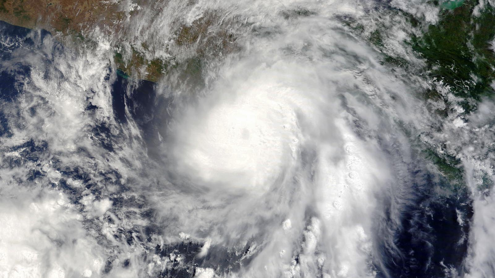
Hurricane Agatha made landfall about 10 miles west of Puerto Angel, Mexico, at about 5 p.m. EDT Monday, May 30. At landfall, Agatha was a category 2 storm with 105 mph winds, making it the strongest landfalling Pacific hurricane on record so early in the year.
Agatha was also the strongest landfalling Pacific hurricane so far east at any time of year. It is unusual to see land-falling Pacific hurricanes so far to the east because of the southerly latitude of southeastern Mexico and Central America, where prevailing winds blow east-to-west. These trade winds tend to steer hurricanes to the west, out to sea. However, in May, strong midlatitude troughs of low pressure can dip far enough to the south to pull hurricanes northward to a landfall, as occurred with Agatha.
Hurricanes are uncommon in May in the eastern Pacific, with 14 on record over the 51-year period 1971-2021. May land-falling hurricanes are very rare in the eastern Pacific. NOAA’s hurricane history database lists only two others: a previous incarnation of Hurricane Agatha on May 24, 1971 (85 mph winds at landfall), and Hurricane Barbara on May 29, 2013 (80 mph winds at landfall).
Agatha dissipates over Mexico
At 11 a.m. EDT Tuesday, the National Hurricane Center issued its final advisory on Agatha, declaring that the low-level center of the storm had dissipated over the rugged terrain of southeastern Mexico. Heavy rains from the hurricane’s remnants will persist, bringing storm total amounts of 10-16 inches to portions of Mexico.


Agatha’s remnants may bring year’s first Atlantic named storm
Agatha’s remnants will merge with a large low-pressure system over Central America and southeastern Mexico, and be caught up in a southwesterly flow that will bring the storm’s spin and moisture over the southern Gulf of Mexico and western Caribbean on Wednesday and Thursday. A number of the ensemble members of the GFS and European models show Agatha regenerating into the Atlantic’s first named 2022 storm by this weekend. Since Agatha’s well-defined circulation did not survive crossing Mexico’s rugged terrain, any storm that forms from Agatha’s remnants would be named Alex. In its 8 a.m. EDT Tuesday Tropical Weather Outlook, NHC gave two-day and five-day odds of Atlantic tropical cyclone formation of 10% and 60%, respectively, to Agatha’s remnants.


Development will be aided by water temperatures in the Gulf that are about one degree
Development will be aided by water temperatures in the southern and eastern Gulf that are about one-half to one degree Celsius (0.9-1.8°F) above average, plus the current position of the Madden-Julian Oscillation (MJO), which will bring a large-scale area of rising air to the Gulf. However, preliminary forecasts suggest that any storm that does form by this weekend in the Gulf would experience high wind shear and dry air on its northwest side. Such a system would likely be incapable of rapid intensification, and would primarily be a heavy rain threat. The odds of development appear to be greater after the system crosses over the Florida Peninsula and enters the waters off the Southeast U.S. coast (Figure 1), beyond the NHC’s 5-day outlook period.
Heavy rains from Agatha’s remnants are likely to begin affecting Cuba on Thursday, and South Florida and western Bahamas on Friday. Seven-day rainfall amounts of five-plus inches are expected over portions of Mexico, Cuba, South Florida, and the western Bahamas by Tuesday, June 7 (Figure 2). Because of dry air to the northwest of the system, a sharp cutoff point for the heavy rains is expected over central Florida.
Bob Henson contributed to this post.
Website visitors can comment on “Eye on the Storm” posts (see below). Please read our Comments Policy prior to posting. (See all EOTS posts here. Sign up to receive notices of new postings here.)
Source link