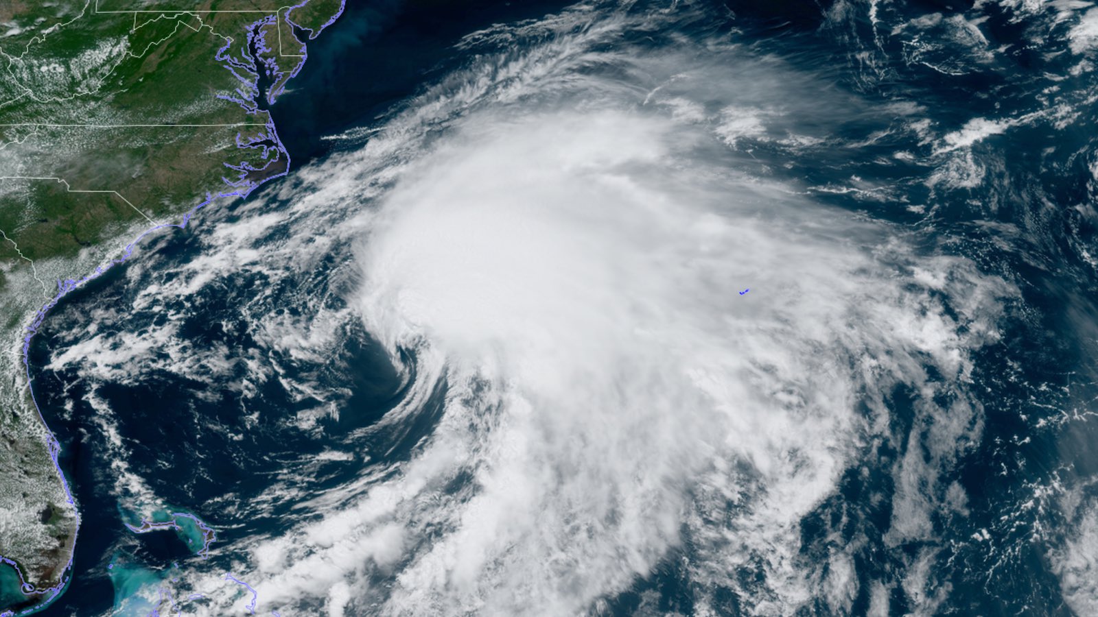
It took a record-long time, but Potential Tropical Cyclone One was finally upgraded to Tropical Storm Alex at 2 a.m. EDT Sunday. At 11 a.m. EDT, Alex was located almost halfway between Florida and Bermuda, accelerating northeast at 23 mph with top sustained winds of 60 mph confirmed by an Air Force hurricane hunter mission. Top winds at flight level were a stout 89 knots (102 mph), but it appeared those winds were not fully mixing to the surface.
As it approaches the Bermuda area, Alex will be traveling over sea surface temperatures of around 26°C (79°F), which are about 1°C above average for early June but still marginal for any tropical development. Moreover, wind shear will remain high (above 20 knots). Thus, any further intensification should be minimal. Alex is predicted to track north of Bermuda on Monday, so its stronger right-hand side may bring 2-3” of rain and tropical-storm-force winds to the island.


Living up to its potential at last
PTC 1 was designated at 5 p.m EDT Thursday, June 2, as a disorganized system near the northeast tip of Mexico’s Yucatan Peninsula. Strong steering flow kept it heading steadily toward South Florida, but the high wind shear kept PTC 1 from forming a sharp low-level circulation and wrapping showers and thunderstorms (convection) around it. Throughout the trek to Florida, PTC 1’s convection was focused toward its east and south side, downstream from the wind shear. Only after crossing Florida on Saturday could PTC 1 achieve a well-defined low-level center, allowing for the upgrade to Alex.
Of the 23 systems launched by the National Hurricane Center as potential tropical cyclones since that designation was introduced by NHC in 2017, PTC 1 took the most time by far to live up to its potential. A total of 57 hours elapsed between the debut of PTC 1 and its upgrade to Alex. The previous record was held by last year’s Claudette, which took 36 hours to go from PTC to tropical depression.
Only one potential tropical cyclone has ever dissipated without making the (up)grade: PTC 10 in 2017 was discontinued after 48 hours of fruitless attempts to develop off the Southeast coast.
Mopping up across South Florida
Before it became Alex, PTC 1 made its mark on South Florida, affecting millions of residents with torrential rain and widespread street flooding. Tropical systems often bring heavy rain to South Florida early in hurricane season. Many cars stalled out on Friday night into Saturday, and some rescues took place, but no serious injuries were reported.
Record daily rainfall totals for Saturday, June 4, included
6.55” at Fort Lauderdale;
5.26” at Miami; and
4.52” at West Palm Beach.
The two-day rainfall total (June 3-4) of 8.65″ at Miami was its heaviest two-day rainfall in any meteorological summer (June-August) since 10.33″ fell on August 29-30, 1932. Even heavier rains have occurred with hurricanes and tropical storms in September.
CoCoRaHS stations reported some exceptional two-day totals exceeding 10″ between Key Largo and Boca Raton, including 11.32″ just southwest of downtown Miami and 13.20″ at Biscayne Park. Brian McNoldy (University of Miami) reported a single-day total of 10.98″ at his home-based CoCoRaHS station on June 4, which happened to be the 10-year anniversary of that station.
High water across a Miami-Dade wastewater treatment plant led to outflows that were more than double the average daily flow, triggering a “no-swim” advisory for much of the area on Saturday. “This weather event produced rains & flows above/beyond the design of any treatment facility,” Miami-Dade Water and Sewer wrote in a tweet.
Is Alex’s formation a harbinger of an active hurricane season?
Early-season Atlantic hurricane activity in June and July usually has very little correlation with how active the season as a whole will be—unless an early-season storm occurs in the tropics (south of 23.5°N). Alex’s formation occurred in the northwestern Bahamas, a location that does not necessarily imply that an active season is ahead.
However, if we get a storm in June or July like we did in 2021 – when Hurricane Elsa formed in the tropical Atlantic in early July and then tracked into the eastern Caribbean – that would likely be a harbinger of an active hurricane season. Since 1900, only seven years have had eastern Caribbean hurricanes prior to August 1: 1926, 1933, 1961, 1996, 2005, 2020, and 2021 (though Hurricane Isaias of 2020 was arguably just outside the Caribbean, becoming a hurricane along the north coast of Dominican Republic on July 31, 2020). All seven of those years were classified as hyperactive Atlantic hurricane seasons using the NOAA definition: an accumulated cyclone energy (ACE index) of at least 160 units.
Is the Atlantic hurricane season starting earlier?
While this year marks the first year since 2014 that the Atlantic has not had its first named storm before the official June 1 start of hurricane season, Alex’s appearance on June 5 comes well before the usual June 20 date of the season’s first storm from the 1991-2020 climatology.
So, is the Atlantic hurricane season getting longer? When considering both the start and end of the Atlantic hurricane season, it does appear to be getting longer in the region south of 30°N and east of 75°W, according to a 2008 paper in Geophysical Research Letters published by Dr. James Kossin of the University of Wisconsin and titled, “Is the North Atlantic hurricane season getting longer?” A 2016 analysis by Dr. Ryan Truchelut of WeatherTiger also supported this idea. However, Juliana Karloski and Clark Evans of the University of Wisconsin-Milwaukee found no trend in tropical cyclone formation dates when looking at the entire Atlantic for the period 1979–2014.
The season is certainly starting earlier, when looking at the formation date of the season’s first named storm (Figure 2). However, the date of the formation of the season’s first hurricane has not changed significantly.


From a societal impact perspective, an earlier start to the season is not a big deal, as hurricanes are generally far more destructive than tropical storms. In a presentation on May 9 at the American Meteorological Society’s 25th Conference on Hurricanes and Tropical Meteorology, NHC branch chief Chris Landsea noted that more than 99% of hurricanes still occur within the June 1–November 30 hurricane season, and that there are no plans to extend the official season at present.
Website visitors can comment on “Eye on the Storm” posts (see below). Please read our Comments Policy prior to posting. (See all EOTS posts here. Sign up to receive notices of new postings here.)
Source link