More than two days after Hurricane Otis slammed into Acapulco, Mexico, as a Category 5 hurricane with 165 mph winds, the full scope of the horrific damage it wrought was only gradually emerging. Communications with the region remain limited, power is mostly out, many roads are still blocked, and the airport has been heavily damaged. The death toll stands at 27 and will surely rise.
Damage from Otis is going to reach many billions of dollars. Catastrophe risk modeling firm CoreLogic estimated that insured damages from Otis would be $10-$15 billion USD. This includes only residential, commercial, industrial, and agricultural structures; government property, infrastructure, crops, and livestock were not included in this estimate, and neither were storm surge or flash flood damage. If this estimate is accurate, it is possible that Otis could challenge the $22 billion cost (2022 USD) of Typhoon Mirelle in Japan from 1991 as the most expensive non-U.S. tropical cyclone in history.
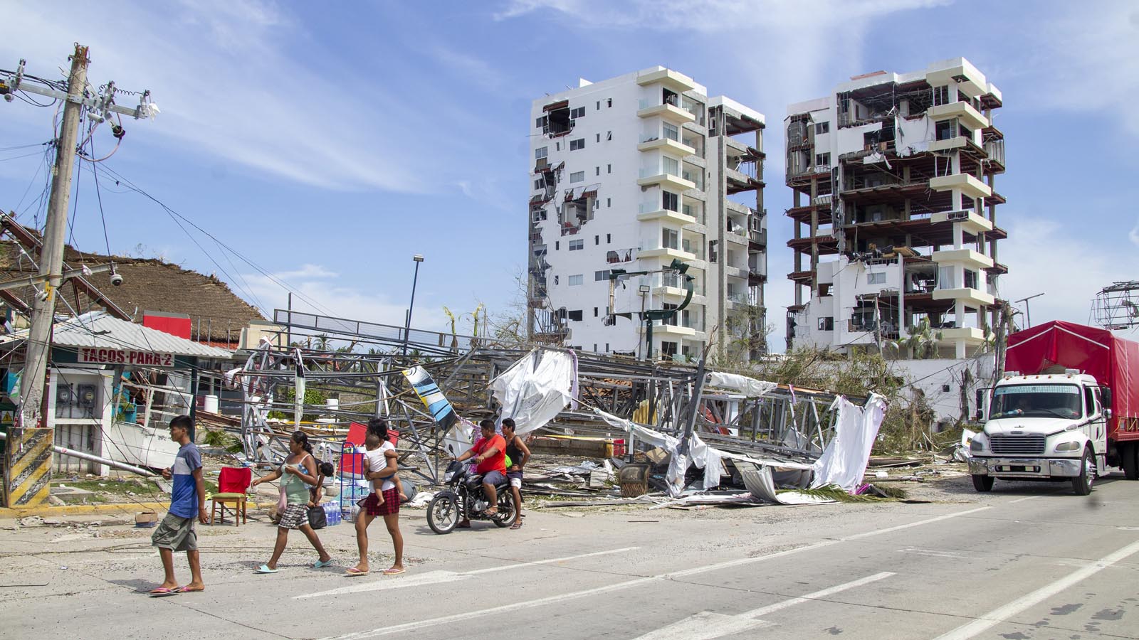
Videos of damages from Otis to high-rise hotels in Acapulco look much more extreme than from Wilma in 2005 done to similar structures in Cancun and Cozumel. Otis was able to blow out all of the window and interior walls in the upper stories of some high rises, hurling the contents of the rooms to the streets below, where pillows from the hotels could be seen strewn about.
Apart from the stunning damage in the high-rises of central and coastal Acapulco, there has been immense suffering and destruction in the city’s more modest neighborhoods, including communities east of downtown and on the hills just above the core city. Details remain limited from these areas, in part because of ongoing enormous challenges in transportation and communication.
Mexico’s previous most expensive weather disaster was $7.5 billion (2022 USD) from Hurricane Wilma of October 2005. Wilma hit Cancun as a Category 4 storm with 150 mph winds, then made a second landfall in Mexico’s Yucatan Peninsula just south of Cancun. According to EM-DAT, the international disaster database, here are the top five most damaging (in inflation-adjusted 2022 USD) weather disasters on record for Mexico:
Costliest weather disasters in Mexican history (2022 USD)
1) Hurricane Wilma (2005): $7.5 billion
2) Hurricane Manuel (2013): $5.3 billion
3) Hurricane (2010): $5.2 billion
4) Tabasco Floods (2007): $4.2 billion
5) Hurricane Stan (2005): $3.7 billion

Otis in historical context
Otis is the strongest hurricane on record to hit Mexico from the Pacific, and Mexico has now seen two of its top-10 strongest hurricane landfalls on record this month, as Otis was preceded by the landfall of Category 4 Hurricane Lidia on October 10. Three hurricanes even stronger than Otis have hit the nation from the Atlantic side. Here are the strongest landfalling Mexican hurricanes (by sustained wind speed at the time of landfall):
1) Dean (2007, Atlantic): 175 mph
1) Anita (1977, Atlantic): 175 mph
1) Janet (1955, Atlantic): 175 mph
4) Otis (2023, Pacific): 165 mph
5) Gilbert (1988, Atlantic): 160 mph
6) Wilma (2005, Atlantic): 150 mph
6) Patricia (2015, Pacific): 150 mph
8) Madeline (1976, Pacific): 145 mph
9) Lidia (2023, Pacific): 140 mph
9) Hurricane 12 (1957, Pacific): 140 mph
9) Kenna (2002, Pacific): 140 mph
9) Mexico Hurricane (1959, Pacific): 140 mph
The Tweet below does a nice job putting Otis in historical context:
Otis is Earth’s ninth Cat 5 storm of 2023
Otis is the world’s ninth Cat 5 storm of 2023, using ratings from the Joint Typhoon Warning Center and National Hurricane Center. The 1990-2022 average globally for an entire calendar year is 5.3 Cat 5s, so 2023 is well above average, tied for third-highest since 1990. The record is 12 Cat 5s in a year, set in 1997. The strongest Cat 5 of 2023 was Super Typhoon Mawar in the Western Pacific, which peaked with 185 mph winds in May.
The other Cat 5s of 2023 include at least one in every major ocean basin prone to tropical cyclones: the Atlantic (Hurricane Lee), Northeast Pacific (Hurricane Jova), Northwest Pacific (Super Typhoon Mawar and Super Typhoon Bolaven), North Indian (Cyclone Mocha), South Indian (Cyclone Freddy and Cyclone Ilsa), and Southwest Pacific (Cyclone Kevin).

Tammy returns from the grave for Halloween weekend
After being consigned to post-tropical-storm status early on Thursday, former Hurricane Tammy has taken a spooky turn and reconstituted itself as a full-fledged tropical storm. According to the National Hurricane Center, Tammy’s pattern of showers and thunderstorms, or convection, now including a symmetric core and spiral banding, has recovered enough to re-designate Tammy as a tropical cyclone. As of 11 a.m. EDT Friday, Tropical Storm Tammy had top sustained winds of 65 mph and was centered about 215 miles east of Bermuda, putting those islands on the edge of tropical-storm-force winds. Tammy was drifting northwest at 3 mph, but increasing westerly steering flow is expected to push it generally eastward by this weekend, away from Bermuda and into the remote central North Atlantic. Strong wind shear of 25-35 mph and dry air (midlevel relative humidity of 40-50%) should keep Tammy on a weakening trend even as it moves over increasingly warm water, rising from around 25 degrees Celsius (77°F) on Friday to around 27 degrees Celsius (81°F) by Monday.

Tammy could remain a named storm for days to come, and it has already racked up some impressive longevity, including six days as a hurricane – from early Friday, October 20, to early Thursday, October 26. That’s one of the longest stretches of hurricane strength for any Atlantic tropical cyclone so late in the season during the 57 years of satellite-based records, according to Phil Klotzbach of Colorado State University.
Time to watch the Caribbean for development
There’s a growing signal in the computer models for a large area of low pressure to form in the Caribbean during the last few days of October and first week of November, during a period when wind shear is predicted to be uncharacteristically low for an El Niño year. The location to watch initially will be the southwestern Caribbean, where an extension of the area of the semi-permanent area of low pressure in the eastern Pacific called the monsoon trough may begin to show some development. Models predict that this area of low pressure will lift slowly northward during the week, bringing heavy rains to Jamaica, Cuba, and Hispaniola on Monday and Tuesday. The broad nature of the low will make it slow to spin up into a tropical cyclone, and in their 8 a.m. EDT Friday Tropical Weather Outlook, the National Hurricane Center gave this system two-day and seven-day odds of development of 0% and 30%, respectively. Later in the week, models point to the possibility of another area of low pressure capable of developing into a tropical depression forming in the western Caribbean.

Invest 92E: a Central American heavy rain threat
A large area of low pressure located a few hundred miles south of El Salvador, designated Invest 92E, was bringing disorganized heavy thunderstorms to the waters along the Pacific coast of Central America. This disturbance has solid model support for development by early next week, and will likely bring heavy rains of four to eight inches to the coasts of El Salvador, Guatemala, Nicaragua, and Honduras Sunday through Wednesday. A slow north-to-northwest motion at about 5 mph is likely through Monday when 92E is expected to be near the coast of El Salvador. The long-range fate of the disturbance is uncertain, as steering current may reverse later in the week, carrying 92E out to sea. In their 8 a.m. EDT Friday Tropical Weather Outlook, the National Hurricane Center gave 92E two-day and seven-day odds of development of 80% and 90%, respectively.
Website visitors can comment on “Eye on the Storm” posts (see comments policy below). Sign up to receive notices of new postings here.
Source link