BOULDER, COLORADO – Several weeks of truly bizarre December weather in the United States – ranging from eerily pleasant to horrific – ended with a fierce windstorm on December 30 that drove Colorado’s most destructive wildfire on record.
A preliminary count showed 991 structures were consumed by the Marshall Fire in exurban and suburban areas between Boulder and Denver. The blaze is just behind California’s Thomas fire (Ventura and Santa Barbara counties, December 2017) as the nation’s most destructive wildfire in modern records for meteorological winter (December through February). The Thomas fire took two lives and destroyed 1,063 structures, according to Cal Fire.
Two people remained missing from the Marshall Fire as of Tuesday morning, January 4.
The fire appears to have started near the hamlet of Marshall, just south of Boulder, where a barn was seen burning around 11:30 a.m. There were hints of smoke elsewhere on video, and investigators were still working on Tuesday to nail down when, where, and how the Marshall Fire began.
Downslope winds gusting to 90 mph at the National Center for Atmospheric Research (NCAR) Mesa Lab, and up to 115 mph near the former Rocky Flats Plant, pushed the fire east at stunning speed. The blaze ripped across snowless open space and farmland dessicated by a record-dry and near-record-warm autumn.


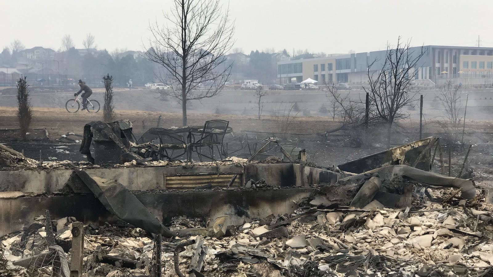
Within several hours, the fire had swept into Superior and Louisville, two towns flanking U.S. Highway 36 between Boulder and Denver. Residents and shoppers fled the area amid a terrifying, disorienting mix of high wind, smoke, and ash.
At least 553 structures were destroyed in Louisville (pop. 21,226) and at least 332 in Superior (pop. 13,094), along with 106 structures in unincorporated Boulder County. A new hotel in Superior was gutted, large parts of the town’s historic center were consumed, and an entire subdivision of more than 100 homes was reduced to ashes.
Across the highway, several swaths of damage tore across Louisville, engulfing several neighborhoods. (Author’s note: This disaster hit particularly close to home for me, since I have a number of friends and colleagues in both Louisville and Superior.)
Evacuation and pre-evacuation notices extended well into the northwest suburbs of Denver before the winds finally subsided by evening of New Years Eve. By New Year’s Day, the first major snowfall since spring 2021 was blanketing the region with long-awaited moisture, painting a dissonant landscape of snow atop ash.

Stan Lanzano, whose destroyed home is pictured at the top of this post, evacuated with his family just minutes before the fire arrived. Virtually their entire block was leveled, yet homes less than 100 feet away were spared.
Pointing to the blaze’s speed and ferocity and its highly localized impacts, Lanzano said, “It seemed more like a tornado than a fire.” As it turns out, there was some rotational component visible from a distance in the immediate smoke plume. However, this was a relatively small fire (around 6,200 acres), and there was no evidence of pyrocumulonimbus (a fire-induced thunderstorm) or any associated tornadic circulation of the type observed in California’s Carr Fire of 2018.
The videos below (click “Watch on YouTube”) show the before-and-after conditions looking north from the Lanzanos’ backyard as the fire approached and on the day after.

One meteorologist’s trial by fire … ‘I felt like a chimney sweep.’
Like other residents, the extensive weather and climate community of the Boulder area was shaken by the fire’s destruction. Many dozens of NCAR and NOAA employees live in Superior and Louisville, both of which offer convenient commutes into Boulder.
Among those who lost their homes in Superior is Jonathan Vigh, a project scientist at NCAR’s Research Applications Laboratory. Vigh developed the NCAR/RAL Tropical Cyclone Guidance Project website in 2011 as an offshoot of his master’s-degree work on ensemble modeling at Colorado State University.
Vigh is now leading a new project, the Hurricane Risk Calculator, to help those in hurricane country gain specifics on their vulnerability. Users input their homes’ structural details into an app that helps them determine when evacuation from high winds might be needed.
In the December 30 fire, Vigh found himself reviewing his own vulnerability to fire – in this case at hyperspeed, with little time to act. Vigh’s home, on the west edge of the Sagamore neighborhood, had an uninterrupted view of the grasslands toward Marshall, so he was among the first to see and sense the danger.


“If you can smell the smoke, and the smoke plume is going right over your head and getting lower and lower with time, that’s a really bad sign,” said Vigh, who’s developed an interest in wildfire science over the past few years.
“The speed at which it progressed was so frightening.”
Vigh’s wife and younger son made it back from a nearby park at 11:50 a.m., just as conditions were quickly deteriorating. Twenty minutes later, they were ready to leave. “When I was loading up the last suitcase in the car, the soot just blasted down on us,” he said. “I felt like a chimney sweep.”
According to neighbors, the west-facing back of Vigh’s house was already on fire by 12:22 p.m. Vigh reckons their house was fully engulfed by 12:38 p.m., less than 30 minutes after he and his family left, based on when his Tempest weather station stopped reporting data.
After an emotionally exhausting drive, Vigh and his family of four ended up at a hotel on the other side of the Denver area. It didn’t take long for Vigh to realize that his entire neighborhood was gone, yet the full reality didn’t hit until he saw aerial imagery. Among other things, the basement washer and drier couldn’t be seen – apparently melted into the grey miasma of debris.
Now staying with friends, Vigh and family have found a temporary home they’ll soon occupy.
“I’ve been in touch with more friends in the last five days than in the last five years,” Vigh said. “I’m feeling a little glow of emotional support from that.” At the same time, he added, “I know the road ahead is very daunting. We are going to make sure that the entire family gets professional counseling to help us process the trauma we’ve experienced.”
Vigh urges everyone to develop – and practice – a safety plan for whatever hazards frequent their area. “If you have a plan, drill it. We didn’t talk about our plan often enough.”
One of the most painful property losses for Vigh was a hard drive, containing years of work, that he’d been keeping in his basement during the pandemic while scrimping on cloud storage, a decision he now rues. “If I’d had a checklist on a clipboard, I wouldn’t have lost my entire digital life – I would have grabbed that hard drive. I wasn’t thinking on all cylinders because of the time urgency of this emergency. That was a really eye-opening loss for us.”
Overall, he says, “we’re just so grateful. Family is what is really important. All our neighbors survived as far as we know. We can cheer for that.”
December in a changing climate
The devastating Marshall Fire came just weeks after a pair of stunning tornado outbreaks. The first, on December 10-11, was the nation’s deadliest and likely most damaging on record for any December, with at least 90 fatalities, chiefly across western and central Kentucky, and a record 69 confirmed tornadoes.
Then, on December 15, a massive cyclone whipped across the central U.S., spawning EF2 tornadoes as far north as Minnesota and Wisconsin – an outbreak unprecedented for December in its northward extent and in the total number of twisters confirmed. The total of 100 tornadoes made it one of the largest one-day outbreaks on record for any time of year, and it broke the December record set just five days earlier.
As we’ve discussed before, the South is no stranger to tornadoes in December. Yet these outbreaks pushed the seasonal envelope hard in terms of numbers, intensities, and northerly latitudes. Even though the U.S. frequency of violent tornadoes is not going up, there’s increasing evidence of a rise in tornado-favorable weather during wintertime, especially toward the Mississippi Valley and Mid-South.
In December 2021, a recurrent pattern of moist, record-warm air across the South and Southeast laid the groundwork for the tornado outbreaks, which also hinged on intense jet-stream dynamics that often arise during La Niña winters. Even before a formal attribution study, it’s not a stretch to conclude that our human-warmed climate is making such air masses more likely in winter – and you do need at least some measure of warmth and instability to get violent tornadoes in December.
Along with setting an avalanche of holiday-season record highs – at least 5,972 daily highs were tied or broken in December, according to NOAA/NCEI – the air mass also contrasted dramatically with intense cold toward western Canada. At upper levels, this northwest-to-southeast contrast (typically stronger during La Niña than during El Niño) has been accompanied by an intense polar jet stream. This recurrent jet not only helped drive the tornadic thunderstorms but also drove high winds into the Denver-Boulder area on December 30, through a mountain-wave pattern notorious for the area’s worst windstorms.
Boulder windstorms haven’t shown any obvious long-term trends. The extreme high wind speeds of the windstorm on December 30 put it among the Boulder area’s most powerful in years, and they clearly drove much of the extremity of the fire behavior. Yet Boulder has been renowned for many decades for its shrieking winter windstorms, and Colorado has had deadly, destructive fires even in midwinter, including one that destroyed almost 100 buildings and killed nine people at Fort Carson, near Colorado Springs, on Jan. 17, 1950.
What’s most exceptional, and most consistent with climate change, is how parched the landscape had gotten by December 30 – a function of both persistently warm temperatures and an unprecedented, months-long rain-and-snow drought.
Together, the drought and the warm air pulled moisture from the landscape via evapotranspiration, transforming grasses born in a wet spring from lush to tinder-dry. Similar processes have accompanied the increasingly common “hot droughts” that have driven increasingly intense fire weather over California and other parts of the west.
If such periods become more common, then the fast-growing Front Range of Colorado may be more vulnerable than previously thought to the kind of high-population fire disasters more often associated with the forest-and-chaparral landscapes of California.
An evocative extended interview in New York magazine with local resident and climate scientist Daniel Swain paints a vivid picture of the fire’s complex meteorology, climate, and geography contexts.
Ultimately, the nation’s freakish, hellish weather catastrophes of this past December (which could easily run over $4 billion in insured losses alone, based on estimates of $3-5 billion from the December 10 tornado outbreak) suggest we’re going to find ourselves more vulnerable year-round to the kind of multifactorial weather disasters made more possible by a warming climate. Tornadoes and wildfires have struck in December before, but the sheer intensity of this month’s events tells us we’d be well advised to take such phenomena as seriously in the depths of winter as we normally might in May or September.
Such events aren’t turned on and off by climate change like a light switch. Instead, they are “climate-enabled and weather-driven.”
Or, as Colorado journalist Allen Best put it, “So this is what climate change looks like: operating on the margins, yet able to dramatically alter the story on center stage.”
How you can help
Rocky Mountain PBS has a useful summary, with links, of options for people interested in helping those affected by the Marshall Fire.
Jeff Masters contributed to this post. For more on potential links between climate change and the Marshall Fire, see the roundups at the Washington Post, weather5280.com, and Big Pivots.
Website visitors can comment on “Eye on the Storm” posts. Comments are generally open for 30 days from date posted. Sign up to receive email announcements of new postings here. Twitter: @DrJeffMasters and @bhensonweather
Source link