What was widely anticipated to be a rough early spring for severe weather (see our March 16 report) is coming to pass. The consequences have already been tragic, with at least 26 lives lost in a tornado outbreak that hammered Mississippi and Alabama on March 24.
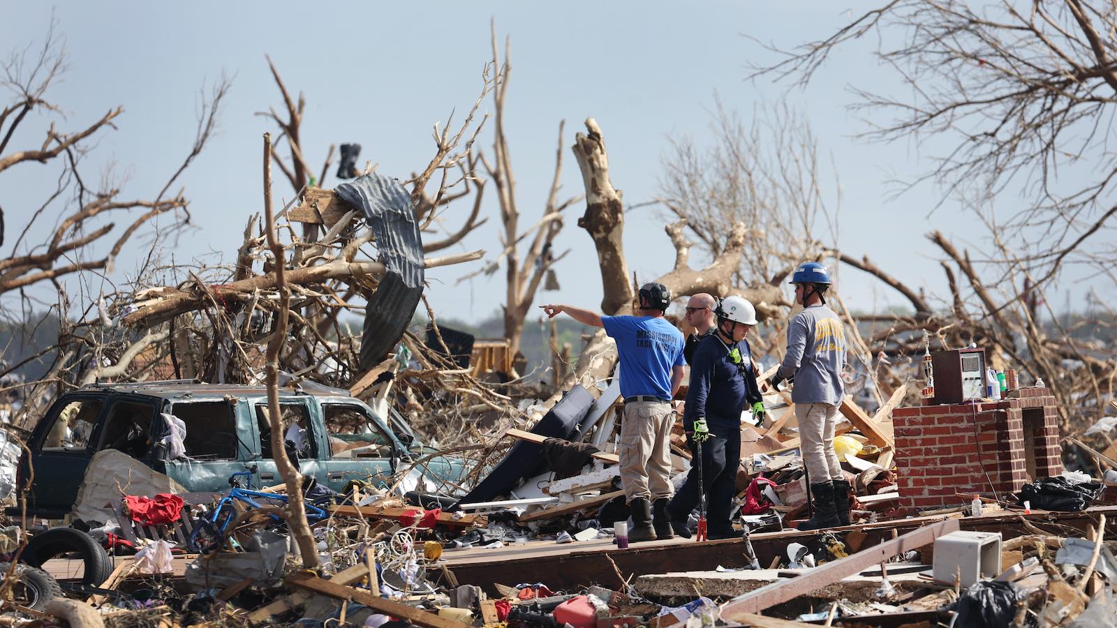
Some of the most poignant scenes have come from the Mississippi Delta town of Rolling Fork (population 1,900), where more than a dozen people were killed and many buildings were ruined when not completely destroyed. The Mississippi Delta is one of the poorest regions of the nation, which will only make it harder for people across the tornado-struck areas to recover.
In a Forbes Science post, Marshall Shepherd (University of Georgia) stressed the inherent vulnerability of the region, based on his own research and that of others: “Everyone is exposed to the tornado, but some people in the region will have greater sensitivity to it and less ability to bounce back.”
What forecasters are watching for late this week and beyond
The large-scale pattern over the next week shows no sign of giving the country a break from severe weather — or giving California a break from heavy rain and snow for that matter. Upper-level storms along a powerful, progressive jet stream will continue to slam into the West Coast, including one on Tuesday, March 28. These storms will then move eastward into the central and eastern U.S., raising the prospect of new rounds of severe weather.
In its Day 4 outlook issued Tuesday, March 28, the NOAA/NWS Storm Prediction Center (SPC) is flagging much of the Plains and Midwest for a potential outbreak of severe weather on Thursday and Friday. After some initial evening storms on Thursday, tornadoes, high wind, and hail could erupt on Friday across a sprawling region from Texas to Illinois. For Friday, SPC placed parts of this area under an enhanced risk, the highest risk category the center uses so far in advance.

Storm-spinning vertical wind shear will be widespread across the region of concern. The main question is low-level moisture. Even a modest amount could be enough to support tornadic storms, with the wind shear being so strong. However, the low-level flow from the Gulf of Mexico may not be warm and moist enough to produce severe weather across the entire outlooked swath, despite the strong upper support. Instead, there may be two pockets of primary focus, one toward an intensifying surface low in or near Iowa and the other – perhaps more prone to tornadic supercells – toward Arkansas.
Looking further out, the European and GFS models are already hinting that early next week could bring the next substantial bout of severe weather, with increasingly rich low-level flow likely to ratchet up instability across the Southern and Central Plains. The location and timing of this threat were still in too much flux for SPC to issue a Day 7-8 outlook area, but the center did note: “…severe potential will likely accompany this system and probabilities will likely be needed in later outlooks.”

More details on the Mississippi tornadoes
Detailed survey results were released Monday night by the NWS office in Jackson for the two most destructive tornadoes of last Friday, which occurred in rapid succession between 7:57 and 9:37 p.m. CST.
The Rolling Fork–Silver City tornado took 16 lives, nearly all in Rolling Fork, making it the state’s deadliest single twister since an F5 tornado killed 38 people in the 2011 Super Outbreak (Apr. 27, 2011). This was also only the second Mississippi tornado to take so many lives during the past 52 years.
The tornado churned along a 59-mile path that was as wide as 3/4 mile, extending northeastward from just east of the Mississippi River. Top winds were estimated at 170 mph, making the tornado a low-end EF4. The survey team found both site-built and manufactured homes in Rolling Fork that were demolished. Several key downtown buildings, including the city hall, police department, and courthouse, were at least partially unroofed, and a number of businesses were destroyed. “Debarking was observed on several hardwood trees, with only stubs of the main branches of some trees remaining,” the team found.

Just four minutes after this tornado dissipated, a new one formed from the same supercell. The new Black Hawk-Winona tornado traversed 29 miles, and its damage path was as wide as 0.7 of a mile. Top winds were estimated at 155 mph, near the middle of the EF3 range. The Black Hawk Independent Church and the Historic Blackhawk School, both nearly a century old, were completely destroyed. Three people were killed northeast of Black Hawk in a mobile home that was tossed some 150 feet.
The night’s third long-track tornado—also rated EF3, with top winds of 155 mph—developed about 50 miles downstream from the first two, producing damage between 10:38 and 11:09 p.m. CDT along a 37-mile path that was up to one mile wide, according to preliminary survey data at the NOAA Damage Assessment Toolkit. Site-built homes along the path suffered widespread roof and wall damage. Several manufactured homes were completely destroyed, including one in which two people died and several others were injured.
A number of briefer, weaker tornadoes occurred across Mississippi and Alabama in Friday’s compact but devastating outbreak.
New research on tornadoes and climate change
Human-caused climate change is clearly heating up the tropical ocean basins, primarily the Gulf of Mexico and Caribbean, that send warm, moist air toward tornado country. Since a number of other factors play into tornado development, though, it’s been difficult to separate out the climate-change influence on any given outbreak with precision. Moreover, in-depth attribution studies are seldom conducted for tornado events.
Looking ahead, a growing number of climate-model projections now suggest that supercell thunderstorms (the type that produce the most dangerous tornadoes, such as those the Mississippi last week) may not only increase overall but also shift eastward, and toward early-spring timing, as the century unfolds.
Rather than extrapolating from global climate models that are too coarse to simulate thunderstorms directly, the newer research is employing regional “convection-permitting” climate models, using various strategies to trim their hefty computational cost.
A recent study on the future of supercells – led by Walker Ashley (Northern Illinois University) and published in January in the Bulletin of the American Meteorological Society – examined both a high-end emission scenario (RCP8.5) and an intermediate scenario (RCP4.5) widely considered to be more likely.
“Despite seasonal differences, it is projected that particularly intense storm rotation will be more prevalent in a future climate under both intermediate and pessimistic greenhouse gas concentration trajectories,” the study found.
Results reveal that supercells will be more frequent and intense in future climates, with robust spatiotemporal shifts in their populations. Supercells are projected to become more numerous in regions of the eastern United States, while decreasing in frequency in portions of the Great Plains. Supercell risk is expected to escalate outside of the traditional severe storm season, with supercells and their perils likely to increase in late winter and early spring months under both emissions scenarios. Conversely, the latter part of the severe storm season may be curtailed, with supercells expected to decrease midsummer through early fall.
Unlike the shockingly-far-north, way-out-of-season, catastrophic outbreaks of December 2021, Friday’s tornadoes closely match what one would expect for an outbreak in late March: a Deep South location, with strong tornadoes extending well after nightfall. They’re also consistent with a 40-year trend in which tornado frequency has been rising disproportionately over the Mississippi Valley and dropping in the Southern Plains.
Ominously, these areas also happen to be among the nation’s most vulnerable to tornadoes.
Friday puts a tragic accent mark on the mobile/manufactured home risk
It appears that most of Friday’s fatalities occurred in manufactured homes (or mobile homes, which the industry uses to refer to those built prior to U.S. Department of Housing and Urban Development codes that came into force in 1976). The risk of such homes in tornadoes — even newer ones — has been exhaustively documented.
Fatality data from SPC bears out the hazard. Of the nine people killed by tornadoes in 2023 prior to Friday, all but one were in mobile/manufactured homes and the other was in a vehicle. Of the 23 tornado deaths in 2022, 15 were in mobile/manufactured homes. These ratios can drop during the most violent years, such as 2021 (24 out of 103 deaths), when some tornadoes can be strong enough to reduce the usual differences.
A 2020 study led by Kevin Ash (University of Florida) found that, of 257 residents of mobile/manufactured homes (MH) in Alabama and Mississippi, “more than 50% of MH residents believe their homes are safe sheltering locations….Study findings also uncovered a perception and vulnerability paradox for these residents: Those who have the means to evacuate their MH often feel they have no need to do so, whereas those who recognize the potential peril of sheltering in their home and want to evacuate often lack the resources and/or self-efficacy to carry out more desirable sheltering plans.”
The NWS outlook-to-watch-to-warning system performed admirably in Friday’s outbreak, as did broadcast meteorologists (see the snippet below from a Twitter thread). However, even the best warnings can’t make an unsafe structure any safer.
“The single most important thing you can do is be in a site-built home, something that’s well-anchored to the ground,” said behavioral scientist and meteorologist Kim Klockow McClain, who heads the multi-institutional Behavioral Insights Unit at the NOAA National Severe Storms Laboratory, in a March 27 interview with the public radio program “1A”.
“You don’t have to get to something perfect that’s FEMA-rated….You can do so well for yourself if you can just get to a friend’s house, a neighbor’s house.”
Jeff Masters contributed to this post.
Website visitors can comment on “Eye on the Storm” posts. Comments are generally open for 30 days from date posted. Sign up to receive email announcements of new postings here. Twitter: @DrJeffMasters and @bhensonweather
Source link