Click on the data points in the hurricane tracker map cone to retrieve current storm information and forecasts. The OFCL model is the official National Hurricane Center storm model. Press play to activate the storm tracker, radar, and satellite map. Use the LAYERS button in the lower right corner to adjust the storm map settings. Click on the links below to follow storm updates in the storm weather feed blogs. The feeds are retrieved automatically during hurricane updates from the NHC and are included in the these locations.
| Hurricane Models - Refer to Map. The OFCL is the official National Hurricane Center model. | |||
|---|---|---|---|
Atlantic Active Storm Imagery
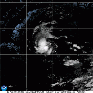
ERIN FLOATER

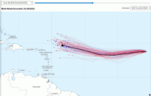
ERIN NHC TRACK
Tropical Cyclone Genesis and Formation Probability


Latest Tropical Weather Blog Posts
Tropical weather and hurricane blog posts from The Eyewall and Tropical Tidbits.
NHC YouTube Video Updates
To view all videos, use the playlist button in the top right.
Tropical Weather Outlook Graphics
Interactive tropical weather outlook, use this link


Tropical Weather Outlook Text
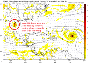
416
ABNT20 KNHC 141738
TWOAT

Tropical Weather Outlook
NWS National Hurricane Center Miami FL
200 PM EDT Thu Aug 14 2025

For the North Atlantic...Caribbean Sea and the Gulf of America:

Active Systems:
The National Hurricane Center is issuing advisories on Tropical
Storm Erin, located east of the Leeward Islands.

Southwestern Gulf (AL98):
Shower and thunderstorm activity has increased in association with
an area of low pressure located over the Bay of Campeche. The low is
forecast to move west-northwestward across the southwestern Gulf
during the next day or so, where environmental conditions are
marginally conducive for further development.  A tropical depression
could form before this system moves inland over northeastern Mexico
or southern Texas by late Friday ending its chances for tropical
development.  Regardless of development, locally heavy rainfall is
possible along portions of northeastern Mexico and southern Texas
over the next few days.  An Air Force Reserve Hurricane Hunter is en
route to investigate this system.
* Formation chance through 48 hours...medium...40 percent.
* Formation chance through 7 days...medium...40 percent.

$$
Forecaster Bucci
