Two tornadic supercell thunderstorms spawned a cluster of strong, highly visible tornadoes on Thursday evening, April 25, in north central Oklahoma. And more severe weather is likely on the way for this weekend in the Arklatex region, northeast Oklahoma, and much of Kansas.
Thursday’s damage
At least 11 people were injured in and near the city of Enid (pop. 50,000), where one powerful twister sideswiped Vance Air Force Base. The base was closed until midday Friday after power had been fully restored.
The Gray Ridge Estates subdivision on the southeast edge of Enid was the hardest-hit area. About 40 homes were damaged overall in Enid and Garfield counties, according to the Oklahoma Department of Emergency Management.

More severe weather incoming
What may end up being the most prolific multiday severe weather outbreak of the spring so far will continue through the weekend. As of midday Friday, the NOAA/NWS Storm Prediction Center had issued sprawling severe weather outlooks covering much of the Southern Plains through Monday. These outlooks centered on pockets of enhanced risk (level 3 of 5) over the Arklatex region on Friday, northeast Oklahoma on Saturday, and much of Kansas on Sunday. There could be periods of tornadic supercells and perhaps a strong tornado or two on Friday or Saturday, but upper-level winds will be on the weaker side compared to Thursday.
As another powerful upper-level system approaches, a higher chance of a more serious outbreak (albeit with uncertainties over timing and location) may be in store on Sunday in Kansas, and perhaps on Monday over the mid-Mississippi Valley of eastern Missouri and Iowa and western Illinois.
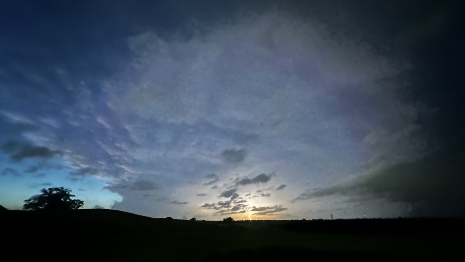
Twin twisters on parade
The supercell that struck Enid Thursday was the southernmost in a line of severe thunderstorms that stretched all the way to Iowa. In classic “zipper” fashion, cells and clusters of storms emerged on Thursday afternoon from north to south along a well-defined cold front. Often in such a scenario, the southern edge of the line is where hot, dry air a couple of miles aloft serves as a “cap” to pinch off any development further south. In such cases, the southernmost storm gets unimpeded access to warm, moist low-level air streaming its way from the Gulf of Mexico, enhancing its odds of tornado production. Moreover, any tornado that develops on the southernmost cell of a line is sometimes easily seen from just a bit farther south, given the absence of intervening storms in the way. Lightning can be visible from dozens of miles away.
As of late Friday morning, a team of damage surveyors organized by the National Weather Service had found damage correlating to at least EF3 intensity on the enhanced Fujita scale. Although many storm chasers can be quick to declare a tornado as “violent” (EF4 or EF5) based on appearance and radar data, the quality of home construction makes a huge difference in the eventual EF rating. It’s the meticulous in-person surveys — working from an exhaustive list of “damage indicators” — that ultimately lead to a tornado’s official strength designation.
Earlier in the afternoon, a supercell that had been the southernmost in the line produced an unusual pair of simultaneous twisters near the town of Braman, one much smaller than the other, a so-called satellite tornado.
As spotlighted in the 2024 film “Twisters,” simultaneous tornadoes from a single supercell aren’t common, but they do happen. A famous example, one that likely inspired the “Twisters” scene, unfolded on June 16, 2004. Two tornadoes from the same storm — both rated EF4 on the enhanced Fujita Scale — overlapped for 26 minutes near Pilger, Nebraska, with their tracks paralleling and eventually crossing each other.
Much more frequent than twin tornadoes are tornado families, in which one tornado dissipates and another emerging from the same supercell mesocyclone follows it within minutes, essentially picking up where the first one left off. Analysis led by the late severe storms forecaster and researcher Robert Johns strengthened the case that the longest-tracked U.S. tornado on record, the 1926 Tri-State Tornado, was in fact a tornado family, as there were multiple damage gaps of at least two miles within its overall track of 235 miles (378 kilometers).
Will the imminent El Niño affect severe weather later this spring?
The ingredients for a formidable 2026-2027 El Niño event continue to build over the western tropical Pacific. Unusually warm water at depth throughout the equatorial Pacific is now emerging across the sea surface. The preconditions at hand, including powerful westerly wind bursts driving warm water across the Pacific, are now roughly comparable to those at work in the top-end El Niño event of 1997–1998.
The new model-based monthly outlook issued April 20 by NOAA and the International Research Institute for Climate and Society has 70% odds that El Niño will be in place for the period April-June, which implies that El Niño is likely to be in progress by May. These are substantially higher odds than pegged by NOAA forecasters just a few days earlier.
With this in mind, it’s safe to say we are now in a “Trans-Niño” spring: one in which either El Niño or La Niña is moving or has moved into its neutral phase. Research suggests that positive-phase Trans-Niño springs — those shifting from La Niña to neutral, as we’ve been doing — tend to be a bit more tornado-favorable, especially in early spring (though there are only a handful of such cases, and there’s variability among them). As for May and June, much will depend on how quickly the imminent El Niño takes shape and how much it influences weather patterns downstream. Typically, such effects are much stronger in fall, winter, and early spring, when the jet stream tends to be stronger.
In line with the overall Trans-Niño-to-El-Niño tendency noted above, the 2026 U.S. tornado season got off to a notably early start, especially across parts of the Upper Midwest and Great Lakes that aren’t accustomed to severe weather so soon in the spring. The astoundingly mild and largely dry weather that prevailed from mid-March through much of April tamped down tornadic activity a bit, but powerful hailstorms extended into Wisconsin.

The season’s preliminary tornado count of 501 through April 23 was nearly 100 above the average for the period 2010-2025. Consistent with a multi-decade shift of peak tornado activity toward the Mississippi Valley since the 1980s (though also reflecting the tendency of early-season tornadoes to be farther east), many of this year’s tornadoes have been clustered from Minnesota, Wisconsin, and Michigan southward to Louisiana, Mississippi, Alabama, and Georgia, with a few ranging across Kansas and Oklahoma.

Most of this year’s tornadoes haven’t hit the top tiers of intensity. Up through last Wednesday, April 23, only a handful of EF3 tornadoes had been confirmed, and none were deemed EF4 or stronger. However, this year still got off to a tragic start with a deadly stretch of severe weather from March 5 through 10. The four tornadoes that struck Michigan on March 6 took four lives, making it the state’s deadliest tornado day since 1980; seven others died in Illinois, Indiana, and Oklahoma during this multiday episode.
In yet another sign that mobile or manufactured homes remain a terrible vulnerability, eight of the 11 tornado deaths in early March (the nation’s only tornado fatalities to date) were in manufactured homes. Two were vehicle-related, and only one was in a site-built home.
Jeff Masters contributed to this post.
![]()
Source link